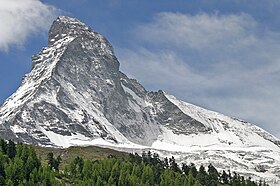
ماتيرهورن
| ||||
|---|---|---|---|---|
| جبل ، ومكان سياحى | ||||
   | ||||
| القاره | اوروبا | |||
| البلد | ||||
| التقسيم الاعلى | كانتون فاليز | |||
| إحداثيات جغرافيه | 45°58′35″N 7°39′31″E / 45.976388888889°N 7.6586111111111°E | |||
| الارتفاع | ||||
| البروز | ||||

| ||||
| تعديل |
||||
| ماتيرهورن | |
|---|---|
| Monte Cervino | |
 الماتيرهورن (الوشين الشرقى و الشمالى, و بينهم Hörnli ridge) | |
| Elevation | 4,478 m (14,692 ft) |
| Prominence | 1,040 m (3,412 ft) [2] |
| Parent peak | Weisshorn |
| Location | |
| Location |
|
| Range | Pennine Alps |
| Coordinates | 45°58′35″N 7°39′30″E / 45.97639°N 7.65833°E |
| Topo map | Swisstopo 1347 Matterhorn |
| Climbing | |
| First ascent | July 14, 1865 by Edward Whymper Charles Hudson Francis Douglas Douglas Robert Hadow Michel Croz Peter Taugwalder (father) Peter Taugwalder (son) |
| Easiest route | Hörnli ridge (AD, rock/mixed climb) |
ماتيرهورن واحد من جبال الألب بتمر عليه الحدود بين سويسرا و ايطاليا.
مصادر[تعديل]
- ↑
{{cite web}}: Empty citation (help) - ↑ Despite its prominence in a local sense, the Matterhorn is not among the top 100 mountains in the Alps measured by topographic prominence. Its close neighbors Monte Rosa, the Dom, Liskamm and the Weisshorn, have higher summits. See a panoramic photograph of the view from Finsteraarhorn, to the north. The key col is Col Durand, at 3,438 metres, between the Matterhorn and the Weisshorn.


