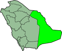
المنطقه الشرقيه
المنطقه الشرقيه
الشرقية | |
|---|---|
| الشرقيه | |
 Map of Saudi Arabia with the Eastern Province highlighted. | |
| Coordinates: 22°30′N 51°00′E / 22.5°N 51°E | |
| Country | السعوديه |
| Capital | Dammam |
| Governorates | |
| Government | |
| • Governor | Prince Saud bin Nayef |
| • Deputy Governor | Ahmed bin Fahd bin Salman bin Abdulaziz Al Saud |
| Area | |
| • Total | 672,522 km2 (259,662 sq mi) |
| • Land | 672,522 km2 (259,662 sq mi) |
| • Water | 0 km2 (0 sq mi) 0% |
| • Rank | 1st |
| Population (2017) | |
| • Total | 4,900,325 |
| • Rank | 3rd |
| • Density | 7.3/km2 (19/sq mi) |
| Postal Code | 3XXXX |
| ISO 3166-2 | SA-04 |
| Area code | 013 |
| HDI (2017) | 0.841[1] very high |

المنطقه الشرقيه منطقه سعوديه عاصمتها الدمام ومن المدن التانيه الاحساء والخبر والظهران و القطيف وحفر الباطن والخفجى والجبيل.
مصادر[تعديل]
- ↑ "Sub-national HDI - Area Database - Global Data Lab". hdi.globaldatalab.org (in الإنجليزية). Retrieved 2018-09-13.
