ساندويل
ساندويل | |
|---|---|
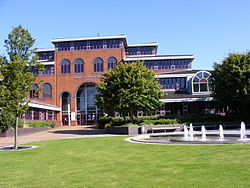
 Sandwell Council House in Oldbury, West Midlands | |
| Motto(s): Unity and Progress | |
 Sandwell shown within the West Midlands and England | |
| Coordinates: 52°30′19″N 2°1′2″W / 52.50528°N 2.01722°W | |
| Sovereign state | المملكه المتحده |
| Constituent country | انجلترا |
| Region | ميدلاند الغربية |
| Metropolitan county | West Midlands |
| Historic County | ستافوردشاير و وسترشير |
| Status | Metropolitan borough |
| Incorporated | 1 April 1974 |
| Admin HQ | Oldbury |
| Government | |
| • Type | Metropolitan district council |
| • Body | Sandwell Metropolitan Borough Council |
| • Leadership | Leader & Cabinet (Labour) |
| • Mayor | Cllr. Barbara Price[1] |
| • MPs | Rt. Hon. John Spellar (L) Adrian Bailey (L) Tom Watson (L) James Morris (C) |
| Area | |
| • Total | 33 sq mi (86 km2) |
| Population (2008 est.) | |
| • Total | 309,000 (Ranked 29th) |
| • Density | 9,720/sq mi (3,752/km2) |
| • Ethnicity | 69.9% White 19.2% Asian 5.9% Black 3.3% Mixed Race 0.3% Arab 1.3% Other[2] |
| Time zone | UTC0 (GMT) |
| • Summer (DST) | UTC+1 (BST) |
| Postcode | |
| Area code(s) | 0121, 01384 |
| ISO 3166 code | GB-SAW |
| ONS code | 00CS (ONS) E08000028 (GSS) |
| OS grid reference | SO9954890217 |
| NUTS 3 | UKG37 |
| Website | www |
ساندويل (انجليزى:Sandwell), دى منطقه حضرى اللى موجوده فى ويست مدلاندز, انجلترا, سكان البشر فى المنطقه دى وصلت 322,700 انسان.[3][4]
مصادر[تعديل]
- ↑ "The Mayor's Office". Councillors, Committees, and Meetings. Sandwell Metropolitan Borough Council. Retrieved 20 August 2015.
- ↑ "Census 2011 Key Stats". Sandwell Trends. Sandwell Metropolitan Borough Council. Archived from the original on 2013-05-13. Retrieved 2 July 2013.
- ↑ "Where is Sandwell?". Sandwell Metropolitan Borough Council. Retrieved 2 July 2013.
- ↑ "Sandwell in Brief". Sandwell Trends. Sandwell Metropolitan Borough Council. Archived from the original on 2017-06-11. Retrieved 2 July 2013.
لينكات برانيه[تعديل]
تصانيف:
- صفحات تحتوي على معاملات formatnum غير عددية
- Articles with short description
- Short description is different from Wikidata
- Pages using infobox settlement with bad settlement type
- Pages using infobox settlement with possible motto list
- Pages using infobox settlement with possible area code list
- ساندويل
- قصبات حضريه


