
ملف:DETAIL OF DOORWAY, EAST SIDE - U. S. Military Academy, West Shore Railroad Passenger Station, West Point, Orange County, NY HABS NY,36-WEPO,1-29-3.tif

حجم معاينة JPG لذلك الملف ذي الامتداد TIF: 749 × 599 بكسل. الأبعاد التانيه: 300 × 240 بكسل | 600 × 480 بكسل | 960 × 768 بكسل | 1,280 × 1,024 بكسل | 2,560 × 2,048 بكسل | 4,971 × 3,977 بكسل.
الصوره الاصليه (4,971 × 3,977 بكسل حجم الفايل: 18.86 ميجابايت، نوع MIME: image/tiff)
الخلاصة
| DETAIL OF DOORWAY, EAST SIDE - U. S. Military Academy, West Shore Railroad Passenger Station, West Point, Orange County, NY | ||||
|---|---|---|---|---|
| العنوان |
DETAIL OF DOORWAY, EAST SIDE - U. S. Military Academy, West Shore Railroad Passenger Station, West Point, Orange County, NY |
|||
| المكان المُصوَّر | New York; Orange County; West Point | |||
| تاريخ | Documentation compiled after 1933 | |||
| الأبعاد | 4 x 5 in. | |||
| الموقع الحالي |
Library of Congress Prints and Photographs Division Washington, D.C. 20540 USA http://hdl.loc.gov/loc.pnp/pp.print |
|||
| رقم التصنيف |
HABS NY,36-WEPO,1-29-3 |
|||
| الإشادة |
|
|||
| ملاحظات |
|
|||
| المراجع |
|
|||
| مصدر | https://www.loc.gov/pictures/item/ny1443.photos.121630p | |||
| سماح (إعادة استخدام الملف ده) |
|
|||

| موقع الكائن | | هذه وغيرها من الصور في مواقعها على: خريطة الشارع المفتوحة |
|---|
تاريخ الفايل
اضغط على الساعه/التاريخ علشان تشوف الفايل زى ما كان فى الوقت ده.
| الساعه / التاريخ | صورة صغيرة | ابعاد | يوزر | تعليق | |
|---|---|---|---|---|---|
| دلوقتي | 17:49، 29 يوليه 2014 | 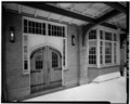 | 4,971 × 3,977 (18.86 ميجابايت) | Fæ | GWToolset: Creating mediafile for Fæ. HABS 24 July 2014 (2301:2600) |
استخدام الفايل
ال1 صفحة دى فيها وصله للفايل ده:
استخدام الملف العام
الويكيات التانيه دى بتستخدم الفايل ده:
- الاستخدام ف en.wikipedia.org