
تكساس
| ||||
|---|---|---|---|---|
  | ||||
 |
 |
|||
 | ||||
| الشعار الوطنى (بالانجليزى: Friendship) (1930–) | ||||
| النشيد: | ||||
| الاسم الاصلى | (بالانجليزى: State of Texas) | |||
| البلد | .svg) | |||
| التقسيم الادارى | امريكا | |||
| الارض و السكان | ||||
| احداثيات | 31°N 100°W / 31°N 100°W [2] | |||
| القاره | امريكا الشماليه | |||
| مسطحات مائيه قريبه | خليج الميكسيك نهر ريو جراندى | |||
| اعلى قمه | جبل جوادالوپ پياك | |||
| اخفض نقطه | خليج الميكسيك | |||
| المساحه | ||||
| نسبة الميه | ||||
| الارتفاع عن مستوى البحر(م) | ||||
| عاصمه | اوستن, تكساس | |||
| التعداد السكانى | ||||
| عدد الاسر | ||||
| الحكم | ||||
| حاكم تكساس | جريج ابوت (20 يناير 2015–) | |||
| التأسيس والسيادة | ||||
| تاريخ التأسيس | 29 ديسمبر 1845 | |||
| بيانات تانيه | ||||
| الرمز الرسمى | محاكى شمالى | |||
| الموقع الرسمى | الموقع الرسمى | |||
| [[تصنيف: غلط فى قوالب ويكى بيانات|]] | ||||

| ||||
| تعديل مصدري - تعديل | ||||

ولاية تكساس (Texas) هى ولايه من ولايات امريكا. ولاية تكساس هيا تانى اكبر ولايه حسب عدد السكان و المساحه ف امريكا. عاصمة تكساس هيا اوستن و اكبر مدنها هيا هيوستن.
تكساس /ˈtɛksəs/ also locally /ˈtɛksɪz/ تكساس ، تيجاس [a] [3] ) هيا ولاية فى المنطقة الجنوبية الوسطى من امريكا . بمساحة 268,596 square miles (695,660 km2) ، و عدد سكانها اكتر من 30 مليون انسان سنة 2023، [4][5][6] هيا تانى اكبر ولاية امريكانيه حسب المساحة (بعد ألاسكا ) والسكان (بعد كاليفورنيا ). تشترك تكساس فى الحدود مع ولايات لويزيانا من الشرق، وأركنساس من الشمال الشرقي، وأوكلاهوما من الشمال، ونيو مكسيكو من الغرب، والولايات المكسيكية تشيهواهوا ، وكواويلا ، ونويفو ليون ، وتاماوليباس من الجنوب والجنوب الغربي؛ ولها خط ساحلى مع خليج المكسيك للجنوب الشرقي.
هيوستن هيا المدينة الاكتر اكتظاظا بالسكان فى ولاية تكساس ورابع اكبر مدينة فى امريكا ، سان أنطونيو هيا تانى اكبر مدينة حسب عدد السكان فى الولاية وسابع اكبر مدينة فى البلاد. تعتبر دالاس فورت وورث وهيوستن الكبرى ، على التوالي، رابع وخامس اكبر المناطق الاحصائية الحضرية فى البلاد. وتشمل المدن الكبرى التانيه أوستن ، تانى اكبر عاصمة ولاية حسب عدد السكان فى امريكا ، و ال باسو . تُلقب ولاية تكساس بولاية النجم الوحيد لوضعها السابق كجمهورية مستقلة ، وكتذكير بكفاح الولاية علشان الاستقلال عن المكسيك . ممكن العثور على النجمة الوحيدة على علم ولاية تكساس وختم ولاية تكساس.[7] أصل اسم تكساس هو من كلمة Caddo táyshaʼ معنى "الأصدقاء".و نظر لحجمها وخصائصها الجيولوجية زى صدع بالكونز ، تحتوى تكساس على مناظر طبيعية متنوعة مشتركة فى المناطق الجنوبية والجنوبية الغربية للولايات المتحدة. رغم أن ولاية تكساس ترتبط شعبى بالصحارى الجنوبية الغربية للولايات المتحدة، لكن أقل من عشرة % من مساحة أراضى تكساس صحراء . معظم المراكز السكانية فى مناطق البرارى السابقة والمراعى والغابات والساحل . وقت السفر من الشرق للغرب، تتراوح التضاريس من المستنقعات الساحلية وغابات الصنوبر لالسهول المتموجة والتلال الوعرة، لالصحراء والجبال فى بيج بيند . مصطلح " 6 أعلام فوق تكساس " هو مصطلح عام يستخدم للاشارة للدول اللى حكمت الاقليم. [b] كانت اسبانيا أول دولة أوروبية تطالب بمنطقة تكساس وتسيطر عليها. بعد مستعمرة قصيرة العمر سيطرت عليها فرنسا، سيطرت المكسيك على الاقليم لحد سنة 1836 لما حصلت تكساس على استقلالها، علشان تكون جمهورية تكساس . و سنة 1845، انضمت تكساس لامريكا باعتبارها الولاية 28.[8] أثار ضم الولاية سلسلة من الأحداث اللى سببت الحرب المكسيكية الامريكانيه سنة 1846. بعد انتصار امريكا ، فضلت تكساس ولاية عبودية لحد الحرب الأهلية الأمريكية ، لما أعلنت انفصالها عن الاتحاد فى أوائل سنة 1861 قبل الانضمام رسمى لالولايات الكونفدرالية الامريكانيه فى مارس. 2. بعد الحرب الأهلية واستعادة تمثيلها فى الحكومة الفيدرالية، دخلت تكساس فترة طويلة من الركود الاقتصادي.
تاريخى، شكلت 4 صناعات رئيسية اقتصاد تكساس قبل الحرب العالمية الثانية : الماشية والبيسون، والقطن، والأخشاب، والنفط. قبل و بعد الحرب الأهلية، كانت صناعة الماشية - اللى هيمنت عليها تكساس - محرك اقتصادى رئيسى للولاية، و خلقت الصورة التقليدية لرعاة البقر فى تكساس. فى أواخر القرن التسعتاشر، بقا القطن والخشب من الصناعات الرئيسية بقت صناعة الماشية أقل ربحية. فى الاخر، سبب اكتشاف الرواسب النفطية الرئيسية ( سبيندلتوب على وجه الخصوص) لحدوث طفرة اقتصادية بقت القوة الدافعة بعد الاقتصاد فى معظم القرن العشرين. طورت تكساس اقتصادًا متنوع وصناعة عالية التقنية فى نص القرن العشرين. As of 2022[update] ، فهى تضم اكبر عدد من المقرات الرئيسية لشركة Fortune 500 (53) فى امريكا .[9][10] مع قاعدة صناعية متنامية، تتصدر الدولة كتير من الصناعات، بما فى ده السياحة والزراعة والبتروكيماويات والطاقة وأجهزة الكمبيوتر والالكترونيات والفضاء والعلوم الطبية الحيوية . قادت تكساس امريكا حسب ايرادات الصادرات الحكومية من سنة 2002 و عندهاتانى أعلى ناتج اجمالى للولاية . لو كانت تكساس دولة اللى ليها سيادة ، لكان عندها عاشر اكبر اقتصاد فى العالم.
اصل الاسم[تعديل]
الاسم تكساس ، بناء على كلمة Caddo táyshaʼ ( /tʼajʃaʔ/ ) تم تطبيق "صديق" فى التهجئة Tejas أو Texas ,[11][12] على ايد الاسبان لCaddo أنفسهم, على وجه التحديد اتحاد Hasinai, النهائى -s ى زى الجمع الاسباني.[13] خلص مهمة سان فرانسيسكو دى لوس تيجاس قرب قرية هاسيناى فى نابداشيس فى مايو 1690، فياللى يتعرف دلوقتى بمقاطعة هيوستن ، شرق تكساس .[14] وقت الحكم الاستعمارى الاسبانى ، فى القرن التمنتاشر، كانت المنطقة معروفه باسم Nuevas Filipinas (" الفلبين الجديدة ") و Nuevo Reino de Filipinas ("مملكة الفلبين الجديدة")، [15] أو باسم provincia de los Tejas ("مقاطعة Tejas ')، [16] بعدين كمان provincia de Texas (أو de Tejas )، ("مقاطعة تكساس").[17] تم دمجها باسم provincia de Texas دخلت الامبراطورية المكسيكية سنة 1821، و أعلنت الجمهورية سنة 1836. تتعرف الأكاديمية الملكية الاسبانية على كلا التهجئة، Tejas Texas ، كأشكال باللغة الاسبانية لاسم ولاية تكساس الأمريكية.[18]
نطق الانجليزية مع /ks/ غير لغوي، و هو ما يتعارض مع القيمة التاريخية للحرف x ( /ʃ / ) فى قواعد الاملاء الاسبانية . ربطت أصول الكلمة البديلة للاسم المتقدمة فى أواخر القرن التسعتاشر اسم تكساس بالكلمة الاسبانية teja ، و تعنى "بلاط السقف"، بصيغة الجمع tejas يتم استخدامها لتعيين مستوطنات بويبلو الأصلية.[19] تُظهر خريطة تعود لستينيات القرن التمنتاشر بقلم جاك نيكولا بيلين قرية تُدعى تيجاس على نهر ترينيتى ، قرب موقع مدينة كروكيت الحديثة.[19]
تاريخ[تعديل]
عصر قبل الاتصال[تعديل]
جوه المكسيك، استمرت التوترات بين الفيدراليين والمركزيين. فى 1835، شكل سكان تكساس لجان للمراسلات و السلامة. الاضطرابات اتطورت لصراع مسلح فى أواخر 1835 فى معركة غونزاليس . [20] ده سبب ثورة تكساس ، و فى شهرين ، تكساس هزمت كل قوات المكسيك فى المنطقة.[21]

تكساس بين مجالين ثقافيين رئيسيين فى أمريكا الشمالية قبل كولومبوس : المناطق الجنوبية الغربية والسهول . اكتشف علما الآثار أن 3 ثقافات أصلية رئيسية عاشت فى دى المنطقة، ووصلت لذروة تطورها قبل الاتصال الأوروبى الأول. و كان دول هم: [22] أسلاف بويبلو من منطقة ريو غراندى العليا، المتمركزة غرب تكساس؛ ثقافة المسيسيبى ، المعروفة كمان باسم Mound Builders ، اللى امتدت على طول وادى نهر الميسيسيبى شرق تكساس؛ وحضارات أمريكا الوسطى ، المتمركزة جنوب تكساس. بلغ تأثير تيوتيهواكان فى شمال المكسيك ذروته حوالى سنة 500 بعد الميلاد و انخفض فى القرن الثامن للقرن العاشر. لما وصل الأوروبيين لمنطقة تكساس، كانت تعيش هناك كتير من الثقافات المختلفة للشعوب الأصلية، المقسمة لكتير من القبائل الأصغر. كانت العائلات اللغوية الموجودة فى الولاية هيا الكادوان ، والأتاكابان ، والأثاباسكان، والكواويلتيكان ، والأوتو-أزتيكان، و كتير من اللغات المعزولة زى تونكاوا . عاشت شعوب Uto-Aztecan Puebloan و Jumano قرب نهر ريو غراندى فى الجزء الغربى من الولاية، وعاشت قبائل أباتشى الناطقة باللغة الأثاباسكانية فى كل اماكن المناطق الداخلية. سيطر كادو الزراعى القائم على بناء التلال على جزء كبير من الجزء الشمالى الشرقى من الولاية، على طول أحواض نهر ريد وسابين ونيشيس . .
عاشت شعوب أتاكابان زى أكوكيسا وبيداى على طول ساحل الخليج الشمالى الشرقي، فى حين عاشت كارانكاوا على طول الساحل الأوسط. كان فيه قبيلة واحدة على الأقل من قبيلة Coahuiltecans، هيا قبيلة الأراناما ، تعيش فى جنوب تكساس. دى المجموعة الثقافية بأكملها، اللى تركزت بشكل أساسى فى شمال شرق المكسيك، انقرضت دلوقتى . صعب تحديد من عاش فى المنطقة الشمالية الغربية من الولاية فى الأصل. بحلول الوقت اللى تم فيه استكشاف المنطقة، كانت تنتمى لالكومانشى المشهورين لحد ما، وهم شعب يوتو أزتيكى آخر تحول لثقافة خيول قوية، لكن يُعتقد أنهم جم بعدين ولم يعيشوا هناك فى القرن الستاشر. قرن. ممكن تمت المطالبة بيها على ايد شوية شعوب مختلفة، بما فى ده سكان يوتو-أزتيك، أو أثاباسكان، أو لحد ديجيهان سيوان
ماكانتش هناك ثقافة مهيمنة فى كل اماكن ولاية تكساس دلوقتى ، و كان كتير من الناس يسكنون المنطقة. [22] القبائل الامريكانيه الأصلية اللى عاشت جوه حدود ولاية تكساس دلوقتى تشمل ألاباما ، أباتشى ، أتاكابان، بيداى ، كادو، أراناما، كومانتش ، تشوكتاو ، كوشاتا ، حسيناى ، جومانو ، كارانكاوا ، كيكابو ، كيوا ، تونكاوا ، و ويتشيتا . [22] هاجر كتير من دى الشعوب من الشمال أو الشرق فى الفترة الاستعمارية، زى الشوكتو و ألاباما-كوشاتا وديلاوير . كانت المنطقة تحت سيطرة الاسبان فى المقام الاولانى فى أول قرنين من الاتصال، لحد ثورة تكساس . كانو مهتمين اكتر بالعلاقات مع الكادو، اللى كانو - زى الاسبان - شعب زراعى مستقر. اتفتح كتير من البعثات الاسبانية فى اقليم كادو، لكن قلة الاهتمام بالمسيحية بين سكان كادو كان يعنى أن عدد التحولات كان قليل. نظر لموقعها بين لويزيانا الفرنسية وتكساس الاسبانية، حافظت قبيلة كادو على علاقات ودية مع كليهما، لكن كانت أقرب لالفرنسيين. بعد سيطرة اسبانيا على لويزيانا، تم اغلاق معظم البعثات فى شرق تكساس وتركها. امريكا حصلت على لويزيانا بعد شراء لويزيانا سنة 1803. فضل الكادو صحبة الأمريكيين وهاجر كل سكانهم بالتقريب لولايتى لويزيانا و أركنساس. شعر الأسبان بالهجر بعد ما أمضوا الكثير من الوقت والجهد وبدأوا فى محاولة جذب الكادو للرجوع، لحد أنهم وعدوهم باراضى اكتر .
امريكا ( اللى ابتدت فى اقناع القبائل بالفصل الذاتى عن البيض عن طريق بيع كل شيء والتحرك غرب من حصولها على شراء لويزيانا) فائض من السكان الأصليين فى ميسورى و أركنساس و تمكنت من التفاوض مع السكان الأصليين. Caddo للسماح لكتير من النازحين بالاستقرار فى الأراضى غير المستخدمة فى شرق تكساس. و كان من بينهم Muscogee ، Houma Choctaw ، Lenape و Mingo Seneca ، من تانيين، اللى شافو الكادوانز كمنقذين، ده خللا الناس دول مؤثرين للغاية.[23][24]
سواء كانت قبيلة امريكانيه أصلية صديقة أو محبة للحرب، كان ده أمر بالغ الأهمية لمصير المستكشفين والمستوطنين الأوروبيين فى تلك الأرض.[25] قامت القبائل الصديقة بتعليم الوافدين الجدد كيفية زراعة المحاصيل المحلية و اعداد الأطعمة وصيد الطرائد البرية . جعلت القبائل الحربية الحياة صعبة وخطيرة على الأوروبيين من فى هجماتهم ومقاومتهم للوافدين الجدد. فى ثورة تكساس، بقت امريكا متورطة بشكل كبير. منعت المعاهدات السابقة مع الاسبان أى من الجنبين من عسكرة سكانه الأصليين فى أى صراع محتمل بين البلدين. فى ده الوقت، ابتدت شوية حوادث عنف مفاجئة بين الأمريكيين الأصليين وسكان تكساس فى الانتشار. واتهم سكان تكساس القبائل، بما فى ده قبيلة كادو، بسرقة الماشية رغم عدم وجود أدلة. رغم عدم العثور على دليل على هوية الجاني، حاول المسؤولون عن ولاية تكساس فى الوقت ده كذا مره القاء اللوم على كادو ومعاقبته علن على الحوادث اللى حاولت حكومة امريكا ابقائهم تحت السيطرة. علاوة على ذلك، الكادو ماستعملوش العنف أبدًا بسبب ده ، باستمدح حالات الدفاع عن النفس.[23]
فى ثورة تكساس، امريكا أتورطت بشكل كبير. منعت المعاهدات السابقة مع الاسبان أى من الجنبين من عسكرة سكانه الأصليين فى أى صراع محتمل بين البلدين. فى ده الوقت، ابتدت شوية حوادث عنف مفاجئة بين الأمريكيين الأصليين وسكان تكساس فى الانتشار. واتهم سكان تكساس القبائل، بما فى ده قبيلة كادو، بسرقة الماشية رغم عدم وجود أدلة. رغم عدم العثور على دليل على هوية الجاني، حاول المسؤولون عن ولاية تكساس فى الوقت ده كذا مره القاء اللوم على كادو ومعاقبته علن على الحوادث اللى حاولت حكومة امريكا ابقائهم تحت السيطرة. علاوة على ذلك، لم يلجأ الكادو أبدًا لالعنف بسبب ذلك، باستمدح حالات الدفاع عن النفس.[23]
أول وثيقة تاريخية تتعلق بتكساس كانت خريطة لساحل الخليج ، أنشأها المستكشف الاسبانى ألونسو ألفاريز دى بينيدا سنة 1519. و بعد تسع سنين ، بقا المستكشف الأسبانى ألفار نونيز كابيزا دى فاكا وجماعته أول أوروبيين فى اللى يتعرف دلوقتى بتكساس. أفاد كابيزا دى فاكا أنه سنة 1528، لما هبط الاسبان فى المنطقة، "مات نصف السكان الأصليين بسبب مرض فى الأمعاء و جابو اللوم علينا ".[26] داخل المكسيك، استمرت التوترات بين الفيدراليين والمركزيين. فى أوائل سنة 1835، شكل سكان تكساس الحذرون لجان للمراسلات والسلامة. اندلعت الاضطرابات لصراع مسلح فى أواخر سنة 1835 فى معركة غونزاليس . [20] ده لاطلاق ثورة تكساس ، وعلى مدار الشهرين التاليين، غلب تكساس كل القوات المكسيكية فى المنطقة.[21]
| Rank | County | Pop. | Rank | County | Pop. | ||||
|---|---|---|---|---|---|---|---|---|---|
 Houston  San Antonio |
1 | Houston | Harris | 2,288,250 | 11 | Laredo | Webb | 256,153 |  Dallas  Austin |
| 2 | San Antonio | Bexar | 1,451,853 | 12 | Irving | Dallas | 254,198 | ||
| 3 | Dallas | Dallas | 1,288,457 | 13 | Garland | Dallas | 242,035 | ||
| 4 | Austin | Travis | 964,177 | 14 | Frisco | Collin | 210,719 | ||
| 5 | Fort Worth | Tarrant | 935,508 | 15 | McKinney | Collin | 202,690 | ||
| 6 | El Paso | El Paso | 678,415 | 16 | Amarillo | Potter | 201,234 | ||
| 7 | Arlington | Tarrant | 392,786 | 17 | Grand Prairie | Dallas | 197,347 | ||
| 8 | Corpus Christi | Nueces | 317,773 | 18 | Brownsville | Cameron | 187,831 | ||
| 9 | Plano | Collin | 288,253 | 19 | Killeen | Bell | 156,261 | ||
| 10 | Lubbock | Lubbock | 260,993 | 20 | Pasadena | Harris | 148,626 | ||
بعد كابيزا دى فاكا، دخلت بعثة هيرناندو دى سوتو تكساس من الشرق، يدورو عن طريق للمكسيك. مرو عبر أراضى كادو لكنهم رجعو بعد الوصول لنهر دايكاو ( ممكن نهر برازوس أو كولورادو)، حيث كان السكان الأصليون بعد ده من البدو الرحل وماكانش عندهم المحلات الزراعية لاطعام الحملة. تجاهلت القوى الأوروبية المنطقة لحد استقرت هناك عن طريق ال غلط سنة 1685. سببت الحسابات الغلطة اللى قام بيها رينيه روبرت كافيلير دى لا سال لانشاء مستعمرة فورت سانت لويس فى خليج ماتاجوردا بدل انشاء مستعمرة على طول نهر الميسيسيبى . [28] استمرت المستعمرة لمدة 4 سنين بس قبل ما تستسلم لظروف قاسية ومواطنين عدائيين. [29] سافرت مجموعة صغيرة من الناجين شرق لأراضى كادو، لكن لا سال اتقتل على ايد أعضاء البعثة الساخطين.
سنة 1690، قامت السلطات الاسبانية، اللى شعرت بالقلق من أن فرنسا تشكل تهديدًا تنافسى، ببناء شوية بعثات فى شرق تكساس بين كادو. [29] بعد مقاومة كادو، رجع المبشرون الاسبان لالمكسيك. [28] ابتدت فرنسا فى استيطان لويزيانا ، معظمها فى الجزء الجنوبى من الولاية، استجابت السلطات الاسبانية سنة 1716 بتأسيس سلسلة جديدة من البعثات فى شرق تكساس. و بعد ده ب سنتين ، أنشأوا سان أنطونيو كأول مستوطنة مدنية اسبانية فى المنطقة. [28]


القبائل الأصلية المعادية والبعد عن المستعمرات الاسبانية المجاورة لم تشجع المستوطنين على الانتقال لالمنطقة. كانت واحدة من المقاطعات الأقل سكان فى اسبانيا الجديدة. [29] سنة 1749، أثارت معاهدة السلام الاسبانية مع ليبان أباتشى غضب كتير من القبائل، [28] بما فى ده كومانتش وتونكاوا وحسيناى . [28] وقعت الكومانشى معاهدة مع اسبانيا سنة 1785 وساعدت بعدين فى هزيمة قبائل ليبان أباتشى وكارانكاوا . [30] مع انشاء المزيد من الارساليات الكتيرة، قاد الكهنة تحول سلمى لمعظم القبائل. بحلول نهاية القرن التمنتاشر، لم يتحول اللا عدد قليل من القبائل البدوية للمسيحية. [29]
.png)
لما اشترت امريكا ولاية لويزيانا من فرنسا سنة 1803، أصرت السلطات الامريكانيه على أن الاتفاقية تشمل تكساس كمان . تم تحديد الحدود بين اسبانيا الجديدة وامريكا أخير عند نهر سابين سنة 1819، عند اللى يتعرف دلوقتى بالحدود بين تكساس ولويزيانا. [28] وحرص على الحصول على أراضٍ جديدة، رفض كتير من المستوطنين الأمريكيين الاعتراف بالاتفاقية. قامت كتير من المماطلة بجمع الجيوش لغزو المنطقة الواقعة غرب نهر سابين. [31] بمناسبة حرب 1812 ، هاجر بعض الرجال اللى فروا من الفلبين (القديمة) اللى كانت تحت سيطرة الاسبان لتكساس (الفلبين الجديدة) ومروا عبرها كمان [32] ووصلو للويزيانا حيث ساعد المنفيون الفلبينيون امريكا فى الدفاع عن نيو أورليانز ضد الغزو البريطانى ، حيث ساعد الفلبينيون فى مستوطنة سان مالو جان لافيت فى معركة نيو أورليانز .[33]
سنة 1821، شملت حرب الاستقلال المكسيكية اقليم تكساس، اللى بقا جزء من المكسيك. [28] نظر لانخفاض عدد سكانها، تم تخصيص المنطقة لولايات و أقاليم تانيه فى المكسيك ؛ كانت المنطقة الأساسية جزء من ولاية كواهويلا اى تيجاس ، لكن الأجزاء التانيه من ولاية تكساس اليوم كانت جزء من تاماوليباس أو تشيهواهوا أو اقليم سانتا فى دى نويفو المكسيك المكسيكى . [34] على أمل أن يؤدى المزيد من المستوطنين لتقليل غارات كومانتش شبه المستمرة، حررت ولاية تكساس المكسيكية سياسات الهجرة للسماح للمهاجرين من بره المكسيك و اسبانيا. [34] حسب نظام الهجرة المكسيكي، تم تخصيص مساحات كبيرة من الأراضى لأصحاب المشاريع ، اللى قاموا بتجنيد المستوطنين من امريكا و اوروبا والجوه المكسيكي. المنحة الأولى لموسى أوستن ، نقلت لابنه ستيفن اف أوستن بعد وفاته.
مستوطنو أوستن، الثلاثمائة القديمة ، اتخذو أماكن على طول نهر برازوس سنة 1822. جلب 3 [34] رجل أعمال آخر المستوطنين لالولاية، و كان معظمهم من امريكا . [34] نما عدد سكان ولاية تكساس بسرعة. سنة 1825، كان عدد سكان تكساس حوالى 3500 انسان ، معظمهم من أصل مكسيكي. [35] بحلول سنة 1834، ارتفع عدد السكان لحوالى 37800 شخص، منهم 7800 بس من أصل مكسيكي.
كان معظم المستوطنين [34] اللى وصلو مع أوستن و بعد فترة وجيزة أشخاص أقل حظ فى الحياة، كانت تكساس خالية من وسايل الراحة الموجودة فى أماكن تانيه فى المكسيك وامريكا انتهك كتير من المهاجرين القانون المكسيكى ، بالخصوص حظر العبودية . جنب محاولات امريكا شرا تكساس، قررت السلطات المكسيكية سنة 1830 حظر استمرار الهجرة من امريكا . [35]
انتهك كتير من المهاجرين القانون المكسيكى علن، و بالخصوص حظر العبودية . و محاولات امريكا شرا تكساس، قررت السلطات المكسيكية سنة 1830 حظر استمرار الهجرة من امريكا . [35] استمرت الهجرة غير الشرعية من امريكا للمكسيك فى زيادة عدد سكان تكساس . [34] دعت القوانين الجديدة كمان لتطبيق الرسوم الجمركية،و ده أثار غضب المواطنين المكسيكيين الأصليين ( تيجانوس ) والمهاجرين الجدد سواء. [31]
استغلو غياب الرقابة للتحريض على المزيد من الحرية السياسية. اجتمع تكساس فى اتفاقية سنة 1832 لمناقشة المطالبة بدولة مستقلة، من قضايا تانيه. [31] وفى العام التالي، كرر سكان تكساس مطالبهم فى اتفاقية سنة 1833 .
جمهورية[تعديل]
داخل المكسيك، استمرت التوترات بين الفيدراليين والمركزيين. فى أوائل سنة 1835، شكل سكان تكساس الحذرون لجان للمراسلات والسلامة. اندلعت الاضطرابات لصراع مسلح فى أواخر سنة 1835 فى معركة غونزاليس . [20] ده لاطلاق ثورة تكساس ، وعلى مدار الشهرين التاليين، غلب تكساس كل القوات المكسيكية فى المنطقة.[21]
جوه المكسيك، استمرت التوترات بين الفيدراليين والمركزيين. فى أوائل سنة 1835، شكل سكان تكساس الحذرون لجان للمراسلات والسلامة. اندلعت الاضطرابات لصراع مسلح فى أواخر سنة 1835 فى معركة غونزاليس . [20] ده لاطلاق ثورة تكساس ، وعلى مدار الشهرين التاليين، غلب تكساس كل القوات المكسيكية فى المنطقة.[21]

انتخب تكساس مندوبين لالمشاورة ،و ده سبب لانشاء حكومة مؤقتة. [36] و بسرعه انهارت الحكومة المؤقتة بسبب الاقتتال الداخلي، و فضلت تكساس بدون حكم واضح فى الشهرين الأولين من سنة 1836.

مندوبين تكساس المنتخبون مضو اتفاقية سنة 1836 بسرعة على اعلان الاستقلال فى 2 مارس، مشكلين جمهورية تكساس . بعد انتخاب أعضاء مؤقتين، تم حل الاتفاقية.[37] انضمت الحكومة الجديدة للمستوطنين التانيين فى تكساس فى Runaway Scrape ، الهربانين من اقتراب الجيش المكسيكي. [38]
بعد شوية أسابيع من التراجع، هاجم جيش تكساس بقيادة سام هيوستن قوات سانتا آنا وهزمها فى معركة سان جاسينتو . تم القبض على سانتا آنا و اجبارها على التوقيع [38] معاهدات فيلاسكو ، منهية الحرب. [38] يحظر دستور جمهورية تكساس على الحكومة تقييد العبودية أو تحرير العبيد، ويطلب من الأشخاص الأحرار من أصل أفريقى مغادرة البلاد.[39] حصلت تكساس على استقلالها، احتدمت المعارك السياسية بين فصيلين فى الجمهورية الجديدة. دعا الفصيل القومي، بقيادة ميرابو ب. لامار ، لاستمرار استقلال تكساس، وطرد الأمريكيين الأصليين ، وتوسيع الجمهورية لالمحيط الهادى . دعا خصومهم، بقيادة سام هيوستن، لضم تكساس لامريكا والتعايش السلمى مع الأمريكيين الأصليين. تجسد الصراع بين الفصائل فى حادثة عرفت باسم حرب أرشيف تكساس .[40] وبدعم شعبى واسع، تقدمت تكساس لأول مرة بطلب ضمها لامريكا سنة 1836، لكن وضعها كدولة تمتلك العبيد جعل قبولها مثير للجدل وتم رفضه فى البداية. ده الوضع، والدبلوماسية المكسيكية المساعدة لمطالباتها بالاقليم، سببت كمان لتعقيد قدرة تكساس على تشكيل تحالفات أجنبية وعلاقات تجارية.
قدم هنود الكومانش المعارضة الامريكانيه الأصلية الرئيسية لجمهورية تكساس، فى غارات متعددة على المستوطنات . أطلقت المكسيك بعثتين صغيرتين لتكساس سنة 1842. تم الاستيلاء على مدينة سان أنطونيو مرتين وهُزم التكساسيون فى معركة فى مذبحة داوسون . و رغم دى النجاحات، لم تحتفظ المكسيك بقوة احتلال فى تكساس، ونجت الجمهورية. سبب انهيار أسعار القطن فى أربعينيات القرن التسعتاشر لركود اقتصاد البلاد.
ولاية[تعديل]
| Rank | County | Pop. | Rank | County | Pop. | ||||
|---|---|---|---|---|---|---|---|---|---|
Houston San Antonio |
1 | Houston | Harris | 2,288,250 | 11 | Laredo | Webb | 256,153 | Dallas Austin |
| 2 | San Antonio | Bexar | 1,451,853 | 12 | Irving | Dallas | 254,198 | ||
| 3 | Dallas | Dallas | 1,288,457 | 13 | Garland | Dallas | 242,035 | ||
| 4 | Austin | Travis | 964,177 | 14 | Frisco | Collin | 210,719 | ||
| 5 | Fort Worth | Tarrant | 935,508 | 15 | McKinney | Collin | 202,690 | ||
| 6 | El Paso | El Paso | 678,415 | 16 | Amarillo | Potter | 201,234 | ||
| 7 | Arlington | Tarrant | 392,786 | 17 | Grand Prairie | Dallas | 197,347 | ||
| 8 | Corpus Christi | Nueces | 317,773 | 18 | Brownsville | Cameron | 187,831 | ||
| 9 | Plano | Collin | 288,253 | 19 | Killeen | Bell | 156,261 | ||
| 10 | Lubbock | Lubbock | 260,993 | 20 | Pasadena | Harris | 148,626 | ||

فى وقت مبكر من سنة 1837، قامت جمهورية تكساس بمحاولات للتفاوض على الضم مع امريكا . سببت المعارضة جوه الجمهورية من الفصيل القومي، جنب المعارضة القوية لالغاء عقوبة الاعدام جوه امريكا ، لابطاء قبول تكساس فى الاتحاد. تم ضم تكساس أخير لما كسب جيمس ك. بولك التوسعى فى انتخابات سنة 1844 .[41] فى 29 ديسمبر 1845، اعترف الكونجرس الأمريكى بولاية تكساس لامريكا باعتبارها ولاية تأسيسية للاتحاد .
كان عدد سكان الولاية الجديدة صغير اوى فى البداية، و كان فيه مزيج قوى بين المستوطنين الأمريكيين الناطقين باللغة الانجليزية اللى هيمنو على الأجزاء الشرقية/الشمالية الشرقية من الولاية والمكسيكيين السابقين الناطقين بالاسبانية ( تيجانوس ) اللى هيمنوا على الأجزاء الجنوبية من الولاية. والأجزاء الغربية. جابت الدولة كتير من المستوطنين الجدد. بسبب الوجود الاسبانى الطويل فى المكسيك وجهود الاستعمار الفاشلة المختلفة اللى قام بيها الاسبان والمكسيكيون فى شمال المكسيك، كان فيه قطعان كبيرة من الماشية اللى ليها القرون الطويلة تجوب الولاية. انها قوية بطبيعتها، لكن مناسبة كمان للذبح والاستهلاك، و مثلت فرصة اقتصادية استغلها كتير من رجال الأعمال، و علشان كده خلق ثقافة رعاة البقر اللى تشتهر بيها تكساس.
حددت تسوية سنة 1850 حدود ولاية تكساس بشكلها الحالي. قام السيناتور الامريكانى جيمس بيرس من ماريلاند بصياغة الاقتراح النهائى حيث تنازلت تكساس عن مطالباتها بالأرض اللى بقت بعدين نصف ولاية نيو مكسيكو دلوقتى ، [42] ثلث ولاية كولورادو ، و أجزاء صغيرة من كانساس ، أوكلاهوما ، ووايومنج للحكومة الفيدرالية مقابل تحمل 10 ملايين دولار من ديون الجمهورية القديمة. نمت ولاية تكساس بعد الحرب بسرعة مع تدفق المهاجرين لأراضى القطن فى الولاية. كما قاموا باحضار أو شراء العبيد الأمريكيين من أصل أفريقي، اللى تضاعفت أعدادهم 3 مرات فى الولاية من سنة 1850 لسنة 1860، من 58000 ل182566.
الحرب الأهلية لحد أواخر القرن التسعتاشر[تعديل]
مش كل سكان تكساس فضلو الانفصال فى البداية، رغم أن كتير منهم دعمو بعدين قضية الجنوب. كان أبرز النقابيين فى تكساس هو حاكم الولاية، سام هيوستن . لعدم الرغبة فى زاد الوضع، رفضت هيوستن عرضين من الرئيس لينكولن لقوات الاتحاد لابقائه فى منصبه. بعد رفض أداء قسم الولاء للكونفدرالية، تم عزل هيوستن من منصب الحاكم. خدم حوالى 2000 من تكساس فى جيش الاتحاد ، مع كون مجموعة كبيرة من المهاجرين الألمان الجدد فى تكساس هيل كانترى معقل وحدوى.[43]
رغم من أنها بعيدة عن ساحات القتال الرئيسية فى الحرب الأهلية الأمريكية ، ساهمت تكساس بأعداد كبيرة من الجنود والمعدات فى بقية الكونفدرالية. احتلت قوات الاتحاد لمده صغيره الميناء الرئيسى للولاية، جالفستون. كانت حدود تكساس مع المكسيك معروفه باسم "الباب الخلفى للكونفدرالية" علشان التجارة كانت تتم على الحدود، متجاوزة حصار الاتحاد.
صدت الكونفدرالية كل محاولات الاتحاد لاغلاق ده الطريق، [44] لكن دور تكساس كدولة امداد تم تهميشه فى نص سنة 1863 بعد استيلاء الاتحاد على نهر الميسيسيبى . دارت المعركة الأخيرة فى الحرب الأهلية فى بالميتو رانش ، قرب براونزفيل، تكساس، و شافت انتصار الكونفدرالية.[45]
تكساس دخلت حالة فوضى شهرين بين استسلام جيش ڤيرچينيا الشمالية وتولى جنرال الاتحاد جوردون جرانجر السلطة. تميزت الأشهر الأولى من اعادة الاعمار بالعنف. يحيى Juneteenth ذكرى اعلان اعلان تحرير العبيد فى جالفستون على ايد الجنرال جوردون جرانجر، بعد سنتين ونصف بالتقريب من الاعلان الأصلي.[46] أعلن الرئيس جونسون، سنة 1866، استعادة الحكومة المدنية فى تكساس. رغم عدم تلبية متطلبات اعادة الاعمار، استأنف الكونجرس السماح لممثلى تكساس المنتخبين بدخول الحكومة الفيدرالية سنة 1870. استمرت التقلبات الاجتماعية حيث كانت الدولة تعانى من الكساد الزراعى وقضايا العمل.
زى معظم ولايات الجنوب، دمرت الحرب اقتصاد تكساس. بس، علشان الولاية ماكانتش تعتمد على العبيد زى أجزاء تانيه من الجنوب، تمكنت من التعافى بسرعة اكبر. أظهرت الثقافة فى تكساس فى أواخر القرن التسعتاشر كتير من جوانب المنطقة الحدودية. بقت الولاية سيئة السمعة باعتبارها ملاذًا للأشخاص من أجزاء تانيه من البلاد اللى أرادوا الهروب من الديون أو توترات الحرب أو مشاكل تانيه. فى الواقع، كان عبارة "ذهب لتكساس" تعبير منتشر لدول اللى يفرون من القانون فى ولايات تانيه. بس، اجتذبت الدولة كمان كتير من رجال الأعمال والمستوطنين التانيين اصحاب المصالح المشروعة كمان .[47]
استمرت صناعة الماشية فى الازدهار، رغم أنها بقت أقل ربحية تدريجى. بقا القطن والخشب من الصناعات الرئيسية ده سبب طفرات اقتصادية جديدة فى مناطق مختلفة من الولاية. نمت شبكات السكك الحديدية بسرعة كما فعل ميناء جالفستون مع توسع التجارة بين تكساس وبقية امريكا (وبقية العالم). زى ما هو الحال مع بعض الولايات التانيه من قبل، توسعت صناعة الأخشاب بسرعة فى تكساس و كانت اكبر صناعة ليها قبل بداية القرن العشرين.[48]
أوائل لنص القرن العشرين[تعديل]

سنة 1900، عانت ولاية تكساس من أعنف كارثة طبيعية فى تاريخ امريكا بسبب اعصار جالفستون .[49] فى 10 يناير 1901، تم اكتشاف أول بير بترول كبير فى تكساس، سبيندلتوب ، جنوب بومونت . تم اكتشاف حقول تانيه بعد كده فى مكان قريب فى شرق تكساس وغرب تكساس و تحت خليج المكسيك . وصلت " الطفرة النفطية " الناتجة لتحويل ولاية تكساس. و بلغ متوسط انتاج البترول 3 ملايين برميل كل يوم عند ذروته سنة 1972.
أقر المجلس التشريعى للولاية اللى يهيمن عليه الديموقراطيين سنة 1901، مشروع قانون دفع ضريبة الاقتراع مقابل التصويت، ده وصل فعلى لحرمان معظم السود و الكتير من الفقرا البيض و اللاتينيين من حق التصويت. كمان أنشأ المجلس التشريعى انتخابات تمهيدية للبيض ، ده ضمن استبعاد الأقليات من العملية السياسية الرسمية. و انخفض عدد الناخبين بشكل كبير، و الديموقراطيين غلبو المنافسة من الحزبين الجمهورى و الشعبوي.[50][51]
الحزب الاشتراكى بقا تانى اكبر حزب فى تكساس بعد سنة 1912، مع انتفاضة اشتراكية كبيرة فى امريكا فى معارك شرسة فى الحركة العمالية وشعبية الأبطال الوطنيين زى يوجين في. دبس . و بسرعهقلت شعبية الاشتراكيين بعد التشهير بهم على ايد حكومة امريكا علشان معارضتهم تورط امريكا فى الحرب العالمية الأولى .[52][53]
وجه الكساد الكبير و أ زمة الغبار ضربة مزدوجة لاقتصاد الولاية، اللى تحسن بشكل ملحوظ من الحرب الأهلية. هجر المهاجرون الأجزاء اكتر تضرر فى تكساس فى سنين Dust Bowl. من ساعتها غادر السود تكساس فى الهجرة الكبرى للحصول على اشتغل فى شمال امريكا أو كاليفورنيا و هروب من اضطهاد الفصل العنصري. سنة 1940، كان 74% من السكان أنجلو ، و 14.4% من السود، و 11.5% من اصول الأسبانية.
الحرب العالمية الثانية كان ليه تأثير كبير على تكساس، الأموال الفيدرالية اتصرفت على بنا قواعد عسكرية و مصانع ذخيرة و معسكرات اعتقال أسرى الحرب و مستشفيات الجيش. 750.000 سابو تكساس للخدمة فى الجيش ؛ المدن كبرت بصناعة جديدة. الكليات اخدت أدوار جديدة؛ و ساب مئات الآلاف من المزارعين الفقرا الغيطان علشان يشتغلو فى وظايف حربية بمرتبات اكبر بكتير و مارجعوش أبدًا للزراعة.
تكساس صنعت 3.1% من اجمالى الأسلحة العسكرية الامريكانيه المنتجة فى الحرب العالمية الثانية، علشان تحتل المرتبة 11 بين الولايات الـ 48. قامت تكساس بتحديث وتوسيع نظام التعليم العالى فى الستينيات. و وضعت خطة شاملة للتعليم العالي، تم تمويلها لحد كبير من عائدات النفط، و جهاز دولة مركزى مصمم لادارة مؤسسات الدولة بشكل اكتر كفاءة. التغييرات دى ساعدت جامعات تكساس تاخد فلوس الأبحاث الفيدرالية.[54]
جغرافيا[تعديل]

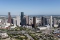
تكساس هيا تانى اكبر ولاية امريكانيه حسب المساحة، بعد ألاسكا ، واكبر ولاية جوه امريكا المتجاورة ، حيث تبلغ مساحتها 268,820 square miles (696,200 km2) . رغم أنها اكبر من فرنسا بنسبة 10%، وما يقرب من ضعف مساحة ألمانيا أو اليابان ، واكتر من ضعف حجم المملكة المتحدة ، الا أنها تحتل المرتبة 27 بس على مستوى العالم بين تقسيمات البلاد الفرعية حسب الحجم . لو كانت ولاية تكساس دولة مستقلة، لكانت فى المرتبة 39 حسب المساحة .[55]
التقسيمات الادارية[تعديل]
فى الولاية 3 مدن يتجاوز عدد سكانها المليون انسان : هيوستن، وسان أنطونيو، ودالاس. دى من المدن العشر الاكتر سكان فى امريكا .
| اكبر مدينة فى ولاية تكساس حسب السنة [56] | |
|---|---|
| سنين) | مدينة |
| 1850-1870 | سان انطونيو |
| 1870-1890 | جالفيستون |
| 1890-1900 | دالاس [56] |
| 1900-1930 | سان انطونيو [57] |
| 1930 للوقت الحاضر | هيوستن |

مطارات[تعديل]

فى تكساس 730 مطار، و هو تانى اكبر عدد من المطارات فى أى ولاية فى البلاد. يعد مطار دالاس/فورت وورث الدولى (DFW) هو الاكبر فى تكساس حسب الحجم والركاب اللى يخدمهم، و هو تانى اكبر مطار حسب المساحة فى امريكا ، والرابع فى العالم بمساحة 18,076 acres (73.15 km2) .[58] حسب حركة المرور، يعد مطار DFW هو الاكتر زحمه فى الولاية، ورابع اكتر المطارات زحمه فى امريكا ، [59] والسادس على مستوى العالم.

أمريكان ايرلاينز التابعة لمجموعة أمريكان ايجل ، اكبر شركة طيران فى العالم حسب اجمالى عدد الركاب والأميال المنقولة وحجم أسطول الركاب، [60] تستخدم مطار دالاس الدولى كاكبر و أهم مركز لها. هيا تُصنف كاكبر شركة طيران فى امريكا حسب عدد الركاب المنقولين محلى كل سنه و اكبر شركة طيران فى العالم حسب عدد الركاب المنقولين.[61] خطوط ساوث ويست الجوية ، و مقرها الرئيسى فى دالاس، تدير عملياتها فى دالاس لاف فيلد .[62]

يوجد حوالى 1150 ميناء بحرى على ساحل تكساس بطول يزيد عن 1,000 miles (1,600 km) من القنوات .[63] توظف الموانئ يقارب من مليون شخص وتتعامل مع ما متوسطه 317 شخص مليون طن مترى .[64] تتصل موانئ تكساس ببقية الساحل الاطلنطى للولايات المتحدة مع قسم الخليج من الممر المائى الساحلى .[63] يعد ميناء هيوستن اليوم اكتر الموانئ زحمه فى امريكا حسب الحمولة الأجنبية، والتانى حسب الحمولة الاجمالية، والعاشر على مستوى العالم حسب الحمولة.[65] تمتد قناة هيوستن للسفن على مسافة 530 feet (160 m) بعرض 45 feet (14 m) بعمق 50 miles (80 km) طويلة.
سكك حديد[تعديل]


الحكومة والسياسة[تعديل]
تم اعتماد دستور تكساس الحالى سنة 1876. زى كتير من الدول ، فانه ينص صراحة على الفصل بين السلطات. تعتبر وثيقة حقوق الولاية اكبر بكثير من نظيرتها الفيدرالية ، ولها أحكام فريدة خاصة بتكساس.[66]
حكومة الولاية[تعديل]

لما شغل الرئيس الجمهورى جورج دبليو بوش منصب حاكم ولاية تكساس، كان للولاية نائب حاكم ديمقراطى ، بوب بولوك . تتكون مناصب السلطة التنفيذية من الحاكم ، ونائب الحاكم ، ومراقب الحسابات العامة، ومفوض الأراضي، والمدعى العام ، ومفوض الزراعة، ولجنة السكك الحديدية فى تكساس المكونة من 3 أعضاء، ومجلس التعليم بالولاية، ووزير الخارجية.[67]
تتكون الهيئة التشريعية فى تكساس من مجلسين : مجلس النواب ، اللى يضم 150 عضو، ومجلس الشيوخ ، اللى يضم 31 عضو. رئيس مجلس النواب يقود مجلس النواب، ونائب الحاكم، مجلس الشيوخ.[68] تجتمع الهيئة التشريعية فى جلسة عادية كل سنتين لمدة تزيد قليل عن مائة يوم، لكن ممكن للحاكم الدعوة لعقد جلسات خاصة كلما رغب فى ده (على وجه الخصوص، مش ممكن للهيئة التشريعية دعوة نفسها للانعقاد).[69] تبدأ السنة المالية للولاية فى شهر سبتمبر 1.[70]
القضاء فى تكساس من اكتر السلطات تعقيدًا فى امريكا ، حيث يضم طبقات كتيرة وسلطات قضائية متداخلة. فيه فى تكساس محكمتان للملاذ الأخير: المحكمة العليا فى تكساس للقضايا المدنية، ومحكمة تكساس للاستئنافات الجبعيده . باستمدح بعض الكراسى البلدية، تختار الانتخابات الحزبية القضاة على كل مستويات السلطة القضائية؛ المحافظ يملأ الشواغر عن طريق التعيين.
تشتهر تكساس باستخدامها لعقوبة الاعدام ، بعد ما قادت البلاد فى عمليات الاعدام من اعادة عقوبة الاعدام فى قضية جريج ضد. قضية جورجيا .[71] قسم Texas Ranger التابع لادارة تكساس للسلامة العامة هو وكالة لانفاذ القانون تتمتع بسلطة قضائية على مستوى الولاية.
على مر السنين، حقق فريق تكساس رينجرز فى جرائم تتراوح بين القتل والفساد السياسي. عملو كبوليس مكافحة الشغب وكمحققين، وقاموا بحماية حاكم ولاية تكساس، و طاردو الهاربين، و عملو كقوة شبه عسكرية للجمهورية وللولاية. اتعمل فريق تكساس رينجرز بشكل مش رسمى على ايد ستيفن اف أوستن سنة 1823 وتم تشكيله رسمى سنة 1835. كان الرينجرز جزء من كتير من الأحداث المهمة فى تاريخ تكساس وبعض أشهر القضايا الجبعيده فى تاريخ الغرب القديم .
يحدد دستور ولاية تكساس مسؤوليات حكومات المقاطعات، اللى تعمل كوكلاء للدولة. يتم انتخاب ما يسمى بالمحكمة المفوضة وقضاة المحكمة ليكونوا يعتبر الذراع الاداري. معظم المدن فى الولاية، اللى يزيد عدد سكانها عن 5000 انسان ، عندها حكومات ذاتية الحكم . الغالبية العظمى منها عندها مواثيق لأشكال الحكم الخاصة بمديرى المجالس ، اللى بموجبها ينتخب الناخبين أعضاء المجلس، اللى يعينون مدير محترف للمدينة كمسؤول تشغيل.[72]
سياسة[تعديل]

فى تسعينيات القرن التسعتاشر، صوت 100 ألف من السود فى الولاية؛ بحلول سنة 1906، كان بامكان 5000 بس التصويت. ونتيجة لذلك، سيطر الحزب الديمقراطى على سياسة تكساس من مطلع القرن، وفرض الفصل العنصرى وتفوق العرق الأبيض. احتفظت بالسلطة لحد بعد اقرار تشريع الحقوق المدنية الوطنى فى نص الستينيات اللى يفرض الحقوق الدستورية لكل المواطنين.[73] رغم أن تكساس كانت فى الأساس دولة اللى ليها حزب واحد فى الوقت ده و كان يُنظر لالانتخابات التمهيدية للحزب الديمقراطى على أنها "الانتخابات الحقيقية"، لكن الحزب الديمقراطى كان يضم فصائل محافظة وليبرالية، اللى بقت اكتر وضوح بعد الصفقة الجديدة . و ذلك، انقسمت شوية فصائل من الحزب لمده صغيره فى تلاتينات و أربعينيات القرن العشرين.[74] ابتدا الناخبين البيض المحافظين فى الولاية بدعم المرشحين الرئاسيين الجمهوريين بحلول نص القرن العشرين. بعد الفتره دى، دعموا الجمهوريين فى المناصب المحلية ومكاتب الولايات كمان ، و بقا معظم البيض أعضاء فى الحزب الجمهوري. واجتذب الحزب كمان بعض الأقليات، لكن الكثير منهم استمروا فى التصويت للمرشحين الديمقراطيين. يُعزى التحول لالحزب الجمهورى لحقيقة أن الحزب الديمقراطى بقا ليبرالى بشكل متزايد فى القرن العشرين، و علشان كده بقا بعيد عن التواصل مع الناخب العادى فى تكساس.[75] وبما أن تكساس كانت دايما ولاية محافظة ، تحول الناخبين لالحزب الجمهوري، اللى يعكس دلوقتى معتقداتهم بشكل أوثق.[75][76] كما عزا المعلقون ده التحول للمستشار السياسى الجمهورى كارل روف ، اللى أدار كتير من الحملات السياسية فى تكساس فى التمانينات والتسعينيات.[76] وشملت الأسباب التانيه المعلنة اعادة تقسيم الدوائر بأمر من المحكمة والتحول ال ديموجرافى بخصوص بحزام الشمس اللى فضل الحزب الجمهورى والمحافظة.
اعادة تقسيم مناطق الكونجرس فى تكساس سنة 2003 بقيادة الجمهورى توم ديلاى ، وصفتها جورنال نيو يورك تايمز بأنها "حالة متطرفة من التلاعب الحزبي". فرت مجموعة من المشرعين الديمقراطيين، "Texas Eleven"، من الولاية فى محاولة لخرق النصاب القانونى لمنع المجلس التشريعى من العمل، لكن مانجحتش. قامت الولاية بالفعل باعادة تقسيم الدوائر بعد تعداد سنة 2000. و رغم الجهود دى ، أقر المجلس التشريعى خريطة لصالح الجمهوريين بشكل كبير، استناد لبيانات سنة 2000 و تجاهل ما يقدر بنحو مليون ساكن جديد فى الولاية من ده الحين.
اعترض المحامون والمحللون المهنيون فى وزارة العدل على الخطة باعتبارها تضعف أصوات الناخبين الأميركيين من أصل أفريقى ومن أصل اسباني، لكن المعينين السياسيين تجاوزوها ووافقو عليها.[77] وصلت الطعون القانونية لاعادة تقسيم الدوائر لالمحكمة العليا الوطنية فى قضية رابطة مواطنى أمريكا اللاتينية المتحدين ضد. بيري (2006)، لكن المحكمة حكمت لصالح الدولة (والجمهوريين). فى انتخابات تكساس 2014 ، حققت حركة حزب الشاى مكاسب كبيرة، حيث تم انتخاب كتير من المرشحين المفضلين لحزب الشاى لمناصبهم، بما فى ده دان باتريك فى منصب نائب الحاكم، كين باكستون فى منصب المدعى العام، [78] فى و كتير من المرشحين التانيين [79] بما فى ده الجمهورى المحافظ جريج أبوت لمنصب الحاكم.
يميل الناخبين فى تكساس نحو المحافظة المالية ، فى حين يستمتعون بفوائد الاستثمار الفيدرالى الضخم فى الولاية فى المؤسسة العسكرية و غيرها من المرافق اللى حققتها قوة الجنوب الصلب فى القرن العشرين. كما أنهم يميلون كمان لتبنى قيم محافظة اجتماعى .[80][81] من سنة 1980، دعم معظم الناخبين فى تكساس المرشحين الرئاسيين الجمهوريين. فى 2000 و 2004، كسب الجمهورى جورج دبليو بوش بولاية تكساس بنسبة 59.3 و 60.1% على التوالي، ويرجع ده جزئى لوضعه "الابن المفضل" كحاكم سابق للولاية. كسب جون ماكين بالولاية فى عام 2008 ، لكن بهامش فوز أقل مقارنة ببوش بنسبة 55 % من الأصوات. تميل أوستن ودالاس وهيوستن وسان أنطونيو باستمرار لالديمقراطيين فى الانتخابات المحلية وعلى مستوى الولاية.[82] سكان المقاطعات على طول نهر ريو غراندى الأقرب للحدودبين المكسيك وامريكا ، حيث فيه كتير من السكان اللاتينيين، يصوتون عموم لمرشحى الحزب الديمقراطي، فى الوقت نفسه تحولت معظم المناطق الريفية والضواحى التانيه فى تكساس لالتصويت لمرشحى الحزب الجمهوري.[83][84]
من انتخابات التجديد النصفى سنة 2022 ، الغالبية العظمى من أعضاء وفد مجلس النواب الأمريكى فى تكساس هم من الجمهوريين ، مع كلا أعضاء مجلس الشيوخ الأمريكى . فى الكونجرس رقم 118 للولايات المتحدة ، من 38 منطقة انتخابية فى تكساس ، 25 منها مملوكة على ايد الجمهوريين و 13 على ايد الديمقراطيين. أعضاء مجلس الشيوخ عن ولاية تكساس هم جون كورنين وتيد كروز . من سنة 1994، لم ينتخب تكساس أى ديمقراطى لمنصب على مستوى الولاية. يتكون الناخبين الديموقراطيين فى الولاية بشكل أساسى من المجموعات الليبرالية والأقليات فى أوستن، وبومونت، ودالاس، و ال باسو، وهيوستن، وسان أنطونيو، و ناخبى الأقليات فى شرق وجنوب تكساس.[85][86]
قانون جنائى[تعديل]
رياضات[تعديل]


كرة القدم الأمريكية تعتبر من فترة طويلة "الملك" فى الولاية، لكن سكان تكساس يستمتعون بمجموعة واسعة من الألعاب الرياضية. ممكن لسكان تكساس أن يهتفوا لعدد كبير من الفرق الرياضية المحترفة. ضمن الدوريات الاحترافية "ال 4 الكبار" ، فيه فى تكساس فريقين من اتحاد كرة القدم الامريكانى ( دالاس كاوبويز وهيوستن تكسانز )، وفريقان من دورى البيسبول الرئيسى ( هيوستن أستروس وتكساس رينجرز )، وثلاثة فرق من الدورى الاميركى للمحترفين ( سان أنطونيو سبيرز ، وهيوستن ). روكتس ، ودالاس مافريكس )، وفريق واحد من دورى الهوكى الوطنى ( دالاس ستارز ). تعتبر مدينة دالاس فورت وورث واحدة من اثنتى عشرة منطقة حضرية امريكانيه بس تستضيف فرق رياضية من كل البطولات الاحترافية "ال 4 الكبار" . بره "ال 4 الكبار"، فيه فى تكساس كمان فريق WNBA ( أجنحة دالاس )، وثلاثة فرق من دورى كرة القدم ( أوستن اف سى وهيوستن دينامو و اف سى دالاس )، وفريق واحد من الدورى الوطنى لكرة القدم الامريكانيه ( هيوستن داش ).
رياضات الجامعه تتمتع بأهمية عميقة فى ثقافة تكساس، بالخصوص كرة القدم . بالولاية 12 مدرسة من مدارس القسم I-FBS ، و هو اكبر عدد فى البلاد. أربع من جامعات الولاية، بايلور بيرز ، تكساس لونجهورنز ، TCU Horned Frogs ، و Texas Tech Red Raiders ، تتنافس فى مؤتمر Big 12 .
ساب فريق Texas A&M Aggies Big 12 وانضم لمؤتمر الجنوب الشرقى سنة 2012، دفع Big 12 لدعوة TCU للانضمام. كان TCU قبل كده فى مؤتمر Mountain West . يتنافس فريق هيوستن كوجر و SMU Mustangs فى المؤتمر الرياضى الامريكانى . يتنافس تكساس ستيت بوبكاتس و يو تى أرلينغتون مافريكس فى مؤتمر صن بيلت . 4 ن مدارس الولاية كسبت بطولة وطنية واحدة على الأقل فى كرة القدم: تكساس لونجهورنز، وتكساس ايه آند ام آجيس، وTCU Horned Frogs، وSMU Mustangs.[87][88][89][90] حسب لسح عمله قسم IA اللى يدرب التنافس بين جامعة أوكلاهوما وجامعة تكساس فى أوستن، Red River Shootout ، يحتل المرتبة التالتة على مستوى البلاد. تشترك TCU Horned Frogs و SMU Mustangs كمان فى التنافس وتتنافس كل سنه فى معركة المقلاة الحديدية .
كمان منافسة شرسة، Lone Star Showdown ، بين اكبر جامعتين فى الولاية، جامعة تكساس ايه آند ام وجامعة تكساس فى أوستن. تم تعليق جزء ألعاب القوى من منافسة Lone Star Showdown بعد انضمام فريق Texas A&M Aggies لالمؤتمر الجنوبى الشرقي.
تنظم الرابطة الجامعية بين المدارس (UIL) معظم مسابقات المدارس الابتدائية والثانوية. تشمل الأحداث اللى تنظمها UIL مسابقات فى ألعاب القوى (الاكتر شعبية هيا كرة القدم فى المدرسة الثانوية ) و الموضوعات الفنية والأكاديمية.[91]
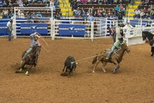
يستمتع سكان تكساس كمان بمسابقات رعاة البقر . تم استضافة أول مسابقات رعاة البقر فى العالم فى بيكوس، تكساس .[92] يعد معرض هيوستن السنوى للماشية ومسابقات رعاة البقر اكبر مسابقات رعاة البقر فى العالم. يبدأ الأمر بجولات درب من شوية نقاط فى كل اماكن الولاية تجتمع فى Reliant Park .[93] يعد معرض Southwestern Exposition and Livestock Show فى فورت وورث أقدم مسابقات رعاة البقر اللى يتم تشغيلها باستمرار اللى تضم كتير من التقاليد الاكتر تاريخية للولاية فى أحداثها السنوية. تستضيف دالاس معرض ولاية تكساس كل سنه فى فير بارك .[94]
يستضيف Texas Motor Speedway سلسلة كأس NASCAR السنوية وسباقات عربيات IndyCar Series من سنة 1997. من سنة 2012، تستضيف حلبة الأمريكتين فى أوستن جولة من بطولة العالم للفورمولا 1 [95] الأولى على حلبة طرق دائمة فى امريكا من سباق الجايزة الكبرى سنة 1980 فى واتكينز جلين انترناشيونال —، و سباق الجايزة الكبرى . سباقات العجل النارية وبطولة التحمل العالمية للاتحاد الدولى للعربيات وسباقات بطولة يونايتد سبورتس كار .[عايز مصدر ]
شوف كمان[تعديل]
مصادر[تعديل]
- ↑ مُعرِّف مكان في موقع "أرش إنفورم" (archINFORM): https://www.archinform.net/ort/2928.htm — تاريخ الاطلاع: 6 اغسطس 2018
- ↑
{{cite web}}: Empty citation (help) - ↑ "Texas" in Diccionario panhispánico de dudas by Royal Spanish Academy and Association of Academies of the Spanish Language, Madrid: Santillana. 2005. ISBN 978-8-429-40623-8.
- ↑ Carlson, Kara. More than 30 million people now call Texas home as state leads US population gains, Austin American-Statesman, December 23, 2022.
- ↑ QuickFacts, Population Estimates, U.S. Census Bureau, July 1, 2022.
- ↑ Press Release. Growth in U.S. Population Shows Early Indication of Recovery Amid COVID-19 Pandemic, U.S. Census Bureau, December 22, 2022.
- ↑ "The State of Texas". Netstate.com. Retrieved April 11, 2010.
- ↑ "Resolutions" (PDF). Twenty-ninth Congress. legisworks.org. 1845. Archived from the original (PDF) on May 25, 2017. Retrieved May 16, 2017.
- ↑ "Texas leads nation as home to the most Fortune 500 companies". FOX 7 Austin. May 24, 2022. Retrieved October 31, 2022.
- ↑ Miranda, Cynthia (May 25, 2022). "Texas houses the most Fortune 500 companies in the nation". KETK.com. Retrieved October 31, 2022.
- ↑ José Arlegui, Chronica de la provincia de N.S.P.S. Francisco de Zacatecas Front Cover (1737), p. 53.
- ↑ "Texas". Online Etymology Dictionary. Douglas Harper. Retrieved February 25, 2007.
- ↑ William Bright, Native American Placenames of the United States, University of Oklahoma Press (2004), p. 491.
- ↑ Weber, David J. (1992), The Spanish Frontier in North America, Yale Western Americana Series, New Haven, Connecticut: Yale University Press, p. 154.
- ↑ المرجع غلط: اكتب عنوان المرجع فى النُص بين علامة الفتح
<ref>وعلامة الافل</ref>فى المرجع:1 - ↑ Oakah L. Jones, Los Paisanos: Spanish Settlers on the Northern Frontier of New Spain, University of Oklahoma Press (1996), p. 277, citing a document dated November 5, 1730.
- ↑ Joseph de Laporte, El viagero universal: Ó, Noticia del mundo antiguo y nuevo vol. 27 (1799), p. 114.
- ↑ "Texas. Grafía recomendada para el nombre de este estado norteamericano. Su pronunciación correcta es [téjas], no [téksas]. Se recomienda escribir asimismo con x el gentilicio correspondiente: texano. Son también válidas las grafías con j (Tejas, tejano), de uso mayoritario en España." Diccionario panhispánico de dudas, Real Academia Española (2005), s.v. Texas.
- ↑ أ ب Charles Dimitry, "American Geographical Nomenclature", Appletons' Journal 15 (1876), 758f.
- ↑ أ ب ت ث Hardin (1994).
- ↑ أ ب ت ث "Texas declares independence". HISTORY. Retrieved February 16, 2021.
- ↑ أ ب ت Richardson et al. 2021.
- ↑ أ ب ت Glover, William B. "A History of the Caddo Indians". Reprinted from 'The Louisiana Historical Quarterly'; Vol. 18, No. 4. October 1935
- ↑ Swanton, John R. Indians of the Southeastern United States (Washington: United States Government Printing Office, 1946) p. 139
- ↑
{{cite book}}: Empty citation (help) - ↑ "The Journey of Alvar Nuńez Cabeza de Vaca". American Journeys. Wisconsin Historical Society. Archived from the original on October 5, 2012.
- ↑ أ ب "Annual Estimates of the Resident Population for Incorporated Places in Texas: April 1, 2010 to July 1, 2019 (SUB-IP-EST2019-ANNRES-48)". United States Census Bureau, Population Division. May 21, 2020. Retrieved December 23, 2022.
- ↑ أ ب ت ث ج ح خ Weber (1992).
- ↑ أ ب ت ث Chipman (1992).
- ↑ Weddle (1995).
- ↑ أ ب ت Davis (2006).
- ↑ "Most of the Filipinos in Texas are comparatively recent arrivals. Strong economic and political ties with the Spanish empire from the 16th to the 19th centuries brought few known individuals to the Americas, but United States control in the early 20th century was responsible for Filipino settlement in every metropolitan area in the state. Considering the Spanish trade with the Philippines—the Manila galleons operated between Acapulco and Manila from 1565 to 1815—travelers from the islands may have been in Mexico after the mid-16th century" (PDF). Texascultures.housing.utexas.edu. Retrieved April 17, 2021.
- ↑ Hinton, Matthew (October 23, 2019). "From Manila to the Marigny: How Philippine pioneers left a mark at the 'end of world' in New Orleans". Very Local New Orleans.
- ↑ أ ب ت ث ج ح Manchaca (2001).
- ↑ أ ب ت Edmondson (2000).
- ↑ Winders (2004).
- ↑ Roberts and Olson (2001), p. 144.
- ↑ أ ب ت Todish, Todish & Spring (1998).
- ↑ "Tarlton Law Library: Constitution of the Republic of Texas (1836): General Provisions". tarlton.law.utexas.edu. Retrieved December 28, 2020.
No free person of African descent, either in whole or in part, shall be permitted to reside permanently in the Republic, without the consent of Congress, and the importation or admission of Africans or negroes into this Republic, excepting from the United States of America, is forever prohibited, and declared to be piracy.
- ↑ "The Archives War". Texas Treasures- The Republic. The Texas State Library and Archives Commission. November 2, 2005. Archived from the original on 2009-01-07. Retrieved January 3, 2009.
- ↑ Buescher, John. "Senatorial Division", Teachinghistory.org, accessed August 21, 2011. Archived يوليه 11, 2011 at the Wayback Machine
- ↑ قالب:Cite Handbook of Texas
- ↑ Andrews, Evan. (August 31, 2018). 6 Southern Unionist Strongholds During the Civil War. History. Retrieved September 21, 2021.
- ↑ المرجع غلط: اكتب عنوان المرجع فى النُص بين علامة الفتح
<ref>وعلامة الافل</ref>فى المرجعCivilwarHB - ↑ February 2006, William Marvel (June 12, 2006). "Battle of Palmetto Ranch: American Civil War's Final Battle". HistoryNet (in الإنجليزية الأمريكية). Retrieved December 28, 2020.
{{cite web}}: CS1 maint: numeric names: authors list (link) - ↑ "Historical Barriers to Voting". Texas Politics. University of Texas. Archived from the original on April 2, 2008. Retrieved October 13, 2008.
- ↑ Pettit, Gwen. "Between the Creeks" (PDF). texashistory.unt.edu. Retrieved December 28, 2020.
The Southern states, especially the hills of Tennessee and Alabama, were impoverished; war tensions still split neighborhoods. Soon, empty houses had crude signs that stated that the former inhabitants had "Gone to Texas." Church records, also, had the phrase, "Gone to Texas" by numerous names on their roles. So many families left Maury County, Tenn., to settle in eastern Collin County, just across East Fork, that several communities, such as Culleoka, have names directly from south Maury County. That group joined relatives that had come here in the 1850s. Most new immigrants had some link to Collin County, which brought them here. They stayed with relatives and friends until they could find a place to settle. Landowners recruited farmers from the old states by persuading relatives and former neighbors to come. However, numerous families, in the pioneer tradition, loaded their children and belongings in a wagon and headed toward the unknown west. Clarksville, Bonham and Dallas newspapers reported how many wagons passed through each day and how many were camped on the "jockey yards" waiting to find a place to settle. Some of these had sold farms and had money to buy land, but most of these immigrants became tenant farmers and worked on shares.
- ↑ "TSHA | Lumber Industry". www.tshaonline.org. Retrieved December 28, 2020.
But relatively, the industry's status is far below its dominant position at the beginning of the twentieth century. Then it was the state's largest manufacturing enterprise, first among Texas industries in generating income, and the largest employer of labor in the Lone Star State.
- ↑ Blake, Eric S.; Rappaport, Edward N.; Landsea, Christopher W. (April 15, 2007). "The Deadliest, Costliest, and Most Intense United States Tropical Cyclones From 1851 to 2006" (PDF). National Weather Service: National Hurricane Center.
- ↑ "Nixon v. Condon. Disfranchisement of the Negro in Texas". The Yale Law Journal. 41 (8): 1212–1221. June 1932. doi:10.2307/791091. JSTOR 791091.
- ↑ "Texas Politics: Historical Barriers to Voting". University of Texas at Austin. 2006. Archived from the original on April 2, 2008.
- ↑ "World War I and the Suppression of Dissent | Wendy McElroy". The Independent Institute. Retrieved December 28, 2020.
- ↑ "'War against war': Americans for peace in World War I – National Constitution Center". National Constitution Center – constitutioncenter.org. Retrieved December 28, 2020.
Morris Hillquit sought to keep alive the ties of his Socialist Party to its comrades abroad. Senator Robert La Follette filled many a speech with praise for progressives in other countries who shared his hatred for militarism. Henry Ford chartered an ocean liner to transport himself and dozens of other activists across the Atlantic, where they lobbied neutral governments to embrace a peace plan they would press on the warring powers. These Americans, like most critics of the war elsewhere in the world, wanted to create a new global order based on cooperative relationships between nation states and their gradual disarmament. Militarism, they argued, isolated peoples behind walls of mutual fear and loathing. Until April 1917, this formidable coalition of idealists—or realists—did much to keep the nation at peace. They may even have had a majority of Americans on their side until just weeks before Congress, at Wilson's behest, voted to declare war. To prevent that from happening, peace activists pressed for a national referendum on the question, confident that "the people" would recoil from fighting and paying the bills in order to help one group of European powers conquer another.
- ↑ Blanton, Carlos Kevin (2005). "The Campus and the Capitol: John B. Connally and the Struggle over Texas Higher Education Policy, 1950–1970". Southwestern Historical Quarterly. 108 (4): 468–497. ISSN 0038-478X.
- ↑ "How Big is Texas Compared to Countries Around the World? Huge". Wide Open Country (in الإنجليزية الأمريكية). May 31, 2017. Retrieved December 28, 2020.
- ↑ أ ب "100 Largest Cities by Decade". U.S. Bureau of the Census. June 15, 1998.
- ↑ المرجع غلط: اكتب عنوان المرجع فى النُص بين علامة الفتح
<ref>وعلامة الافل</ref>فى المرجعSATX TSHA - ↑ "Facts about DFW". Dallas/Fort Worth International Airport. Archived from the original on September 12, 2008. Retrieved October 14, 2008.
- ↑ Jennifer LeClaire. "10 Great Places for Aviation and Aerospace". Southern Business and Development. Archived from the original on July 16, 2011. Retrieved April 28, 2008.
- ↑ Investor Relations. "American Airlines | Investor Relations | News Release". Phx.corporate-ir.net. Retrieved August 2, 2014.
- ↑ International Air Transport Association. "Scheduled Passengers Carried". Archived from the original on September 28, 2007. Retrieved June 10, 2007.
- ↑ "We Weren't Just Airborne Yesterday". Southwest Airlines. May 2, 2007. Retrieved June 9, 2007.
- ↑ أ ب "About Texas Ports". Texas Ports Association. Retrieved May 7, 2008.
- ↑ "Benefits of Texas Ports". Texas Ports Association. Archived from the original on July 28, 2011. Retrieved May 7, 2008.
- ↑ "General Information". The Port of Houston Authority. March 31, 2008. Archived from the original on May 9, 2008. Retrieved May 7, 2008.
- ↑ "Bill of Rights (Article 1)". Texas Politics. University of Texas. Archived from the original on February 6, 2009. Retrieved October 13, 2008.
- ↑ "The Plural Executive". Texas Politics. University of Texas. 2005. Archived from the original on September 28, 2008. Retrieved May 7, 2008.
- ↑ "Membership". Texas Politics. University of Texas. 2005. Archived from the original on March 2, 2009. Retrieved June 17, 2008.
- ↑ "Special Sessions". Texas Politics. University of Texas. 2005. Archived from the original on March 2, 2009. Retrieved June 17, 2008.
- ↑ "FY 2021 State Budget Status". www.ncsl.org. Retrieved December 28, 2020.
- ↑ "Texas again leads U.S. in executions in 2018, and Dallas was top county, with 4". Dallas News. December 15, 2018. Retrieved December 28, 2020.
- ↑ "Council-manager government". Ballotpedia. Retrieved December 28, 2020.
- ↑ "TSHA | Democratic Party". www.tshaonline.org. Retrieved December 28, 2020.
- ↑ المرجع غلط: اكتب عنوان المرجع فى النُص بين علامة الفتح
<ref>وعلامة الافل</ref>فى المرجعPoliticalPartiesTSHA - ↑ أ ب "History of Texas Voters". NewsChannel10. KFDA-TV. November 8, 2016. Retrieved December 16, 2016.
- ↑ أ ب "How Texas Became a "Red" State". Frontline. PBS. April 12, 2005. Retrieved December 16, 2016.
- ↑
{{cite news}}: Empty citation (help) - ↑ المرجع غلط: اكتب عنوان المرجع فى النُص بين علامة الفتح
<ref>وعلامة الافل</ref>فى المرجعFernandez - ↑ المرجع غلط: اكتب عنوان المرجع فى النُص بين علامة الفتح
<ref>وعلامة الافل</ref>فى المرجعGrissom - ↑ "Texas Political Culture—Introduction". Texas Politics. University of Texas. Archived from the original on December 20, 2008. Retrieved May 29, 2008.
- ↑ "Texas Political Culture—Low Taxes, Low Services Political Culture". Texas Politics. University of Texas. Archived from the original on January 30, 2009. Retrieved October 13, 2008.
- ↑ "Red State, Blue Cities". City Journal. September 12, 2016. Retrieved October 9, 2020.
- ↑ "2000 Presidential General Election Results—Texas". US Election Atlas. Retrieved July 22, 2008.
- ↑ "2004 Presidential General Election Results—Texas". uselectionatlas.org. Retrieved July 22, 2007.
- ↑ Cameron, Mandi Cai, Matthew Watkins, Anna Novak and Darla (November 6, 2020). "In Texas, Biden's urban wins couldn't offset Trump's millions of votes in rural, red counties". The Texas Tribune. Retrieved December 28, 2020.
{{cite web}}: CS1 maint: multiple names: authors list (link) - ↑ Ramsey, Ross (November 11, 2016). "Analysis: The blue dots in Texas' red political sea". The Texas Tribune. Retrieved December 28, 2020.
- ↑ "Texas Longhorns Four-Time Football National Champions Bobblehead Unveiled" (in الإنجليزية البريطانية). August 27, 2019. Retrieved December 28, 2020.
- ↑ "Texas A&M Picked Up Two National Championships, Two Conference Titles Over The Summer". Deadspin (in الإنجليزية الأمريكية). September 7, 2012. Retrieved December 28, 2020.
- ↑ "National Champions!!! TCU Earns Third Title In Program History". TCU Athletics. March 9, 2019. Retrieved December 28, 2020.
- ↑ Dymeck, Pete. "National Treasure: SMU's Forgotten, Yet Glorious Football History". Bleacher Report. Retrieved December 28, 2020.
- ↑ "University Interscholastic League". University of Texas at Austin. Archived from the original on February 21, 2006. Retrieved September 28, 2008.
- ↑ "View Atlas Data". Atlas.thc.state.tx.us. Archived from the original on September 4, 2015. Retrieved April 11, 2010.
- ↑ "Houston Rodeo Tickets". Houston Livestock Show and Rodeo. 2008. Archived from the original on September 13, 2008. Retrieved April 20, 2008.
- ↑ "Fair Park, Texas". City of Dallas. Archived from the original on May 14, 2008. Retrieved May 22, 2008.
- ↑ "Formula One returns to the United States". Formula 1 Administration Ltd. Retrieved May 25, 2010.
المرجع غلط: <ref> فى تاجز موجوده لمجموعه اسمها "lower-alpha", بس مافيش مقابلها تاجز <references group="lower-alpha"/> اتلقت