قالب:Infobox Prefecture Japan/doc
| This is a documentation subpage for قالب:Infobox Prefecture Japan. It may contain usage information, categories and other content that is not part of the original قالب page. |
| This template uses Lua: |
Usage[تعديل]
{{{Name}}} Prefecture
{{{JapaneseName}}} | |
|---|---|
| Japanese transcription(s) | |
| • يابانى | {{{JapaneseName}}} |
| • Rōmaji | {{{Rōmaji}}} |
| {{{LocalLanguage1}}} transcription(s) | |
| • {{{LocalLanguage1}}} | {{{LocalName}}} |
| • Rōmaji | {{{LocalTranscription1}}} |
|
[[File:{{{Flag}}}|100px|right|border|Flag of {{{Name}}} Prefecture]] Flag [[File:{{{Symbol}}}|80px|right|Official logo of {{{Name}}} Prefecture]] Symbol | |
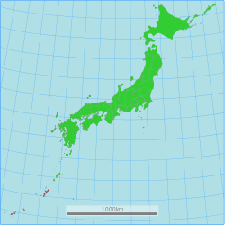
| [[File:{{{Map}}}|250px|right|Location of {{{Name}}} Prefecture]] | |
| Coordinates: خطأ لوا في package.lua على السطر 80: module 'Module:ISO 3166/data/JP' not found. | |
| Country | Japan |
| Region | {{{Region}}} |
| Island | {{{Island}}} |
| Capital | {{{Capital}}} |
| Government | |
| • Governor | {{{Governor}}} |
| Area | |
| • Total | {{{TotalArea}}} km2 (Formatting error: invalid input when rounding sq mi) |
| • Rank | {{{AreaRank}}} |
| Population ({{{PopDate}}}){{{population_footnotes}}} | |
| • Total | {{{Population}}} |
| • Rank | {{{PopRank}}} |
| ISO 3166 code | {{{ISOCode}}} |
| Districts | {{{Districts}}} |
| Municipalities | {{{Municipalities}}} |
| Flower | {{{Flower}}} |
| Tree | {{{Tree}}} |
| Bird | {{{Bird}}} |
| Fish | {{{Fish}}} |
| Website | {{{Website}}} |
{{Infobox Prefecture Japan
| Name                =
| JapaneseName        =
| Rōmaji              =
| LocalName           =
| LocalLanguage1      =
| LocalTranscription1 =
| Flag                =
| Symbol              =
| Map                 =
| coordinates         = <!-- use {{Coord}} -->
| ISOCode             =
| Region              =
| Island              =
| Capital             =
| LargestCity    = <!--only used if largest city is not the prefectural capital-->
| Governor            =
| TotalArea           =
| PCWater             =
| AreaRank            =
| Population          =
| PopDate             =
| PopRank             =
| Density             =
| Districts           =
| Municipalities      =
| Flower              =
| Tree                =
| Bird                =
| Fish                =
| Website             = <!-- use {{URL}} -->
}}
Example[تعديل]
Okinawa Prefecture
沖縄県 | |
|---|---|
| Japanese transcription(s) | |
| • يابانى | 沖縄県 |
| • Rōmaji | Okinawa-ken |
| Okinawan transcription(s) | |
| • Okinawan | 沖縄県(ウチナーチン) |
| • Rōmaji | Uchinaa-chin |
 | |
| Country | Japan |
| Region | Kyushu |
| Island | Okinawa |
| Capital | Naha |
| Government | |
| • Governor | Takeshi Onaga |
| Area | |
| • Total | 2,271.30 km2 (876.95 sq mi) |
| • Rank | 44th |
| Population (October 1, 2013) | |
| • Total | 1,416,587 |
| • Rank | 27th |
| • Density | 622/km2 (1,610/sq mi) |
| ISO 3166 code | JP-47 |
| Districts | 5 |
| Municipalities | 41 |
| Flower | Deego (Erythrina variegata) |
| Tree | Pinus luchuensis ("ryūkyūmatsu") |
| Bird | Okinawa woodpecker (Sapheopipo noguchii) |
| Fish | Banana fish (Caesio diagramma, "takasago", "gurukun") |
| Website | www |
{{Infobox Prefecture Japan
| Name                = Okinawa
| JapaneseName        = {{lang|ja|沖縄県}}
| Rōmaji              = Okinawa-ken
| LocalName           = {{lang|ja|沖縄県(ウチナーチン)}}
| LocalLanguage1      = [[Okinawan language|Okinawan]]
| LocalTranscription1 = Uchinaa-chin
| Flag                = Flag of Okinawa Prefecture.svg
| Symbol              = Emblem of Okinawa Prefecture.svg
| Capital             = [[Naha]]
| Region              = [[Kyushu]]
| Island              = [[Okinawa Island|Okinawa]]
| coordinates         =
| TotalArea           = 2,271.30
| AreaRank            = 44th
| PCWater             = 0.5
| PopDate             = October 1, 2013
| Population          = 1,416,587
| PopRank             = 27th
| Density             = 622
| Districts           = 5
| Municipalities      = 41
| ISOCode             = JP-47
| Website             = {{URL|http://www.pref.okinawa.jp/english/}}
| Flower              = Deego (''[[Erythrina variegata]]'')
| Tree                = ''[[Pinus luchuensis]]'' ("ryūkyūmatsu")
| Bird                = [[Okinawa woodpecker]] (''Sapheopipo noguchii'')
| Fish                = Banana fish (''Caesio diagramma'', "takasago", "gurukun")
| Map                 = Map of Japan with 47 Okinawa prefecture.svg
| Governor            = [[Takeshi Onaga]]
}}
Microformat[تعديل]
The HTML markup produced by this template includes an hCard microformat, which makes the place-name and location parsable by computers, either acting automatically to catalogue articles across Wikipedia, or via a browser tool operated by a person, to (for example) add the subject to an address book. Within the hCard is a Geo microformat, which additionally makes the coordinates (latitude & longitude) parsable, so that they can be, say, looked up on a map, or downloaded to a GPS unit. For more information about the use of microformats on Wikipedia, please see the microformat project.
Sub-templates[تعديل]
If the place or venue has "established", "founded", "opened" or similar dates, use {{start date}} for the earliest of those dates unless the date is before 1583 CE.
If it has a URL, use {{URL}}.
Please do not remove instances of these sub-templates.
Classes[تعديل]
hCard uses HTML classes including:
- adr
- agent
- category
- county-name
- extended-address
- fn
- label
- locality
- nickname
- note
- org
- region
- street-address
- uid
- url
- vcard
Geo is produced by calling {{coord}}, and uses HTML classes:
- geo
- latitude
- longitude
Please do not rename or remove these classes nor collapse nested elements which use them.
Precision[تعديل]
When giving coordinates, please use an appropriate level of precision. Do not use {{coord}}'s |name= parameter.
Tracking category[تعديل]


