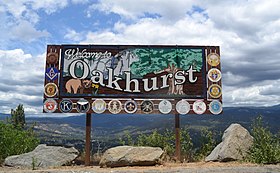
اواخورست, كاليفورنيا
المظهر
| ||||
|---|---|---|---|---|
 | ||||
 | ||||
| البلد | ||||
| الارض و السكان | ||||
| احداثيات | 37°19′53″N 119°38′52″W / 37.33139°N 119.64778°W | |||
| المساحه | ||||
| نسبة الميه | ||||
| الارتفاع عن مستوى البحر(م) | ||||
| التعداد السكانى | ||||
| عدد الاسر | ||||
| الحكم | ||||
| التأسيس والسيادة | ||||
| بيانات تانيه | ||||
| رمز الاتصال الهاتفى المحلى | 559 | |||

| ||||
| تعديل مصدري - تعديل | ||||
اواخورست (انجليزى: Oakhurst), دى منطقه امريكانيه بتاع كاليفورنيا, المنطقه دى اتآسست فى 1873, وعدد سكان بنى آدمين مش يعدى 2,829 انسان.[1][2][3]
مصادر
[تعديل]- ↑ "2010 Census Interactive Population Search: CA - Oakhurst CDP". U.S. Census Bureau. مؤرشف من الأصل في 2014-07-15. اطلع عليه بتاريخ 2014-07-12.
- ↑ "U.S. Census website". United States Census Bureau. اطلع عليه بتاريخ 2008-01-31.
- ↑ "Statewide Database". UC Regents. مؤرشف من الأصل في 2015-02-01. اطلع عليه بتاريخ 2014-11-18.
لينكات برانى
[تعديل]Wikivoyage has a travel guide for Oakhurst.
![]() الصفحه دى فيها تقاوى مقاله عن امريكا. و انت ممكن تساعد ويكيپيديا مصرى علشان
تكبرها.
الصفحه دى فيها تقاوى مقاله عن امريكا. و انت ممكن تساعد ويكيپيديا مصرى علشان
تكبرها.


