
ملف:Kingdom of France 1000.svg

حجم معاينة PNG لذلك الملف ذي الامتداد SVG: 485 × 340 بكسل. الأبعاد التانيه: 320 × 224 بكسل | 640 × 449 بكسل | 1,024 × 718 بكسل | 1,280 × 897 بكسل | 2,560 × 1,795 بكسل.
الصوره الاصليه (ملف SVG، اساسا 485 × 340 بكسل، حجم الملف: 1.22 ميجابايت)
الخلاصة
.هذا الرسم المتجهي أُنشئ بواسطة Inkscape


.svg)
.svg)
.svg)
.svg)
.svg)


.svg)
.svg)
.svg)


.png)
.png)


.svg)


.svg)

.svg)


.svg)
.svg)
.svg)
.svg)


.svg)
.png)


.svg)


.svg)
.svg)


.svg)


.svg)


.svg)
.svg)
.svg)
.svg)
.svg)
.svg)
.svg)
.svg)
_cropped.svg)
.svg)
.svg)
.svg)
.svg)
.svg)
.svg)
.svg)
.svg)
.svg)
.svg)
.svg)
.svg)
.svg)
.svg)
.svg)
.svg)
.svg)
.svg)
.svg)
.svg)
.svg)
.svg)
.svg)
.svg)
.svg)
.svg)
.svg)
.svg)
.svg)
.svg)
.svg)
.svg)
.svg)
.svg)
.svg)
.svg)
.svg)
.svg)
.svg)
.svg)
.svg)
.svg)
.svg)
.svg)
.svg)
الترخيص
هذا الملفُّ مُرخَّصٌ برخصة المشاع الإبداعي الدَّوليَّة المُلزِمة بنسب العمل إلى مُؤَلِّفه وبترخيص المُشتقَّات بالمثل 4.0.
- إنت حر:
- فى المشاركه – علشان نسخ و توزيع و بث العمل
- إنك تمزج – فى تكييف العمل
- بالشروط دى:
- نسبه ل – لازم يتنسب العمل للى مألفه بشكل مناسب و توفير رابط للرخصه وتحديد اذا حصلت تغييرات. ممكن ده يتعمل بأى طريقه معقوله، لكن مش بطريقه تشير ان مانح الرخصه بيوافقك على الاستعمال.
- مشاركه زي – لو عدت إنتاج المواد أو غيرت فيها، لازم تنشر مساهماتك اللى جايه من الأصل تحت ترخيص الأصل نفسه أو تحت ترخيص متوافق معاه.
تاريخ الفايل
اضغط على الساعه/التاريخ علشان تشوف الفايل زى ما كان فى الوقت ده.
| الساعه / التاريخ | صورة صغيرة | ابعاد | يوزر | تعليق | |
|---|---|---|---|---|---|
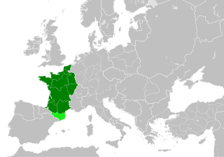
| دلوقتي | 22:55، 19 يوليه 2023 | | 485 × 340 (1.22 ميجابايت) | Wario2 | The counties of Barcelona and Aragon were autonomous (de facto independent) and not an integral part of the realm) |
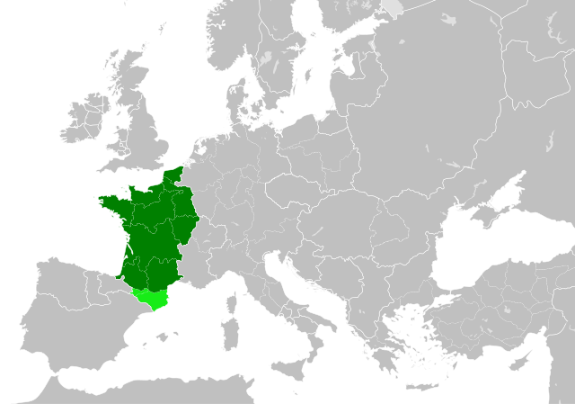
| 16:22، 23 مايو 2016 |  | 485 × 340 (1.25 ميجابايت) | Alphathon | Corrected Flanders and incorporated some islands into their respective counties/duchies | |
| 14:41، 23 مايو 2016 |  | 485 × 340 (1.25 ميجابايت) | Alphathon | Corrected status of Bohemia | |
| 18:13، 22 مايو 2016 |  | 485 × 340 (1.23 ميجابايت) | Alphathon | Split Capua from Benevento and removed both from HRE, along with Spoleto | |
| 16:46، 22 مايو 2016 |  | 485 × 340 (1.24 ميجابايت) | Alphathon | == {{int:filedesc}} == {{Inkscape}} {{Information |Description={{en|A map of the en:Kingdom of France within Europe circa 1000 CE. The main subdivisions of the Byzantine Empire, Holy Roman Empire, Burgundy, France and Poland are also shown.}} |So... |
استخدام الفايل
ال1 صفحة دى فيها وصله للفايل ده:
استخدام الملف العام
الويكيات التانيه دى بتستخدم الفايل ده:
- الاستخدام ف cs.wikipedia.org
- الاستخدام ف da.wikipedia.org
- الاستخدام ف en.wikipedia.org
- الاستخدام ف es.wikipedia.org
- الاستخدام ف fa.wikipedia.org
- الاستخدام ف he.wikipedia.org
- الاستخدام ف it.wikipedia.org
- الاستخدام ف ko.wikipedia.org
- الاستخدام ف mn.wikipedia.org
- الاستخدام ف nrm.wikipedia.org
- الاستخدام ف simple.wikipedia.org
- الاستخدام ف sl.wikipedia.org
- الاستخدام ف th.wikipedia.org
- الاستخدام ف tr.wikipedia.org
- الاستخدام ف uk.wikipedia.org
- الاستخدام ف ur.wikipedia.org
- الاستخدام ف vi.wikipedia.org
- الاستخدام ف www.wikidata.org
- الاستخدام ف zh.wikipedia.org
.svg)