
ملف:Europe 814.png

حجم البروفه دى: 777 × 600 بكسل. الأبعاد التانيه: 311 × 240 بكسل | 622 × 480 بكسل | 995 × 768 بكسل | 1,280 × 988 بكسل | 1,393 × 1,075 بكسل.
الصوره الاصليه (1,393 × 1,075 بكسل حجم الفايل: 169 كيلوبايت، نوع MIME: image/png)

الخلاصة
| وصف |
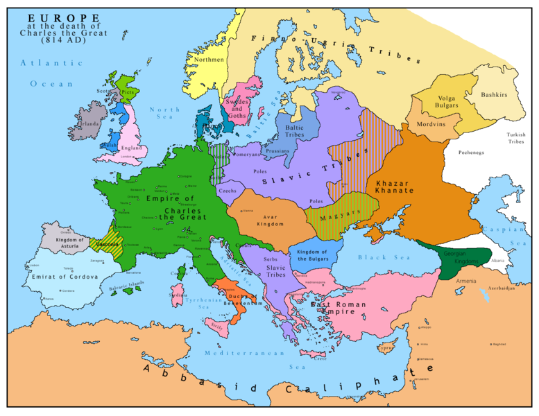
English: Map of Europe after the death of Charles the Great (814 AD). Original map made by Charles Colbeck, The Public Schools Historical Atlas (1905). |
|||
| تاريخ | 2009-04-15. Source date: 1905 by Longmans, Green; New York, London, Bombay 1905. | |||
| مصدر | Own work based on: Europe 814.jpg | |||
| مؤلف | Bukkia (مناقشه · تعديلات) | |||
| إصدارات أخرى |
|


الترخيص
| أنا، مالِك حقوق تأليف ونشر هذا العمل، أجعله في النِّطاق العامِّ، يسري هذا في أرجاء العالم كلِّه. في بعض البلدان، قد يكون هذا التَّرخيص غيرَ مُمكنٍ قانونيَّاً، في هذه الحالة: أمنح الجميع حق استخدام هذا العمل لأي غرض دون أي شرط ما لم يفرض القانون شروطًا إضافية. |
_en.png)
.png)
.jpg)
تاريخ الفايل
اضغط على الساعه/التاريخ علشان تشوف الفايل زى ما كان فى الوقت ده.
| الساعه / التاريخ | صورة صغيرة | ابعاد | يوزر | تعليق | |
|---|---|---|---|---|---|
| دلوقتي | 11:09، 26 ابريل 2023 | | 1,393 × 1,075 (169 كيلوبايت) | OrionNimrod | Reverted to version as of 13:52, 23 December 2015 (UTC) restore |
| 16:09، 2 مايو 2019 |  | 1,370 × 1,047 (124 كيلوبايت) | Julieta39 | Slavs also in the Avars and Bulgars kingdoms | |
| 13:52، 23 ديسمبر 2015 |  | 1,393 × 1,075 (169 كيلوبايت) | Ercwlff | at that time armenia was already part of Arab caliphate.. and there were several Georgian kingdoms or principalities in the north of them | |
| 13:52، 8 يونيه 2015 |  | 1,393 × 1,075 (157 كيلوبايت) | Zorion | Vasconia in rebellion | |
| 17:49، 28 مايو 2015 |  | 1,393 × 1,075 (156 كيلوبايت) | Zorion | From 812 to 824, Vasconia was ruled by Vascons (sourced can be found anywhere in spanish, basque or french). This map was wrong for that specific year. Seems that historian wanted to credit a famous king but, he was dead when Wasconia got back under th... | |
| 15:58، 24 اغسطس 2014 |  | 1,393 × 1,075 (230 كيلوبايت) | Martin H. | Reverted to version as of 14:53, 31 January 2010: File is consistent with its source file File:Europe 814.jpg; change conflicts with en:Duchy_of_Vasconia#Carolingian duchy (769–864) | |
| 14:42، 24 اغسطس 2014 |  | 1,393 × 1,075 (156 كيلوبايت) | Zorion | Vasconia was independant from frankish kingdom until 824 | |
| 14:53، 31 يناير 2010 |  | 1,393 × 1,075 (230 كيلوبايت) | Bukkia | == {{int:filedesc}} == {{Information |Description={{it|1=Mappa dell'Europa alla morte di Carlo Magno (814 d.C.)}} {{en|1=Map of Europe after the death of Charles the Great (814 AD, in Italian)}} |Source=Based on File:Europe 814.jpg |Author=[[user:Buk |
استخدام الفايل
ال1 صفحة دى فيها وصله للفايل ده:
استخدام الملف العام
الويكيات التانيه دى بتستخدم الفايل ده:
- الاستخدام ف bo.wikipedia.org
- الاستخدام ف da.wikipedia.org
- الاستخدام ف de.wikipedia.org
- الاستخدام ف el.wikipedia.org
- الاستخدام ف en.wikipedia.org
- الاستخدام ف es.wikipedia.org
- الاستخدام ف fa.wikipedia.org
- الاستخدام ف fr.wikipedia.org
- الاستخدام ف gl.wikipedia.org
- الاستخدام ف he.wikipedia.org
- الاستخدام ف hu.wikipedia.org
- الاستخدام ف hy.wikipedia.org
- الاستخدام ف id.wikipedia.org
- الاستخدام ف it.wikipedia.org
- الاستخدام ف ko.wikipedia.org
- الاستخدام ف lmo.wikipedia.org
- الاستخدام ف lv.wikipedia.org
- الاستخدام ف mk.wikipedia.org
- الاستخدام ف pl.wikipedia.org
- الاستخدام ف ro.wikipedia.org
- الاستخدام ف sh.wikipedia.org
- الاستخدام ف sr.wikipedia.org
- الاستخدام ف sw.wikipedia.org
- الاستخدام ف uk.wikipedia.org