
ملف:Madhhab Map2.png
حجم البروفه دى: 800 × 388 بكسل. الأبعاد التانيه: 320 × 155 بكسل | 640 × 310 بكسل | 1,245 × 604 بكسل.
الصوره الاصليه (1,245 × 604 بكسل حجم الفايل: 50 كيلوبايت، نوع MIME: image/png)

|
هذه religion map الصورة / الصورتان باستعمال رسومات متجهية ملفات رسوميات شعاعية.
It is recommended to name the SVG file "Madhhab Map2.svg" - then the template Vector version available (or Vva) does not need the new image name parameter.
|
الخلاصة
| وصف |
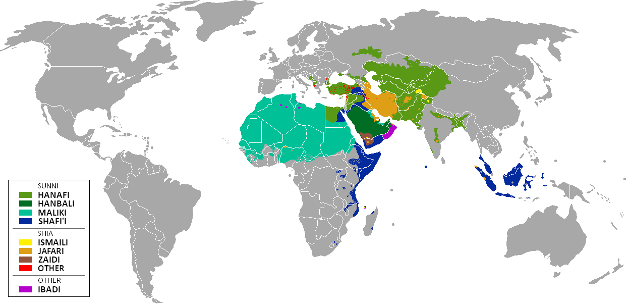
العربية: المدارس الفقهية الإسلامية الرئيسيّة وانتشارها حول العالم (لغة إنجليزية)
فارسی: نقشهٔ پراکندگی مذاهب فقهی اسلام در جهان (انگلیسی)
English: The distribution of the predominant Islamic madhhab (school of law) followed in majority-Muslim countries and regions (English)
Bahasa Indonesia: Distribusi penyebaran agama islam berdasarkan Mahdab di negara-negara dan wilayah dunia |
| تاريخ | |
| مصدر | Own work by uploader from a blank-map, based on this source: Legal Sources and various other sources |
| مؤلف | Ghibar |
| إصدارات أخرى |
Derivative works of this file: |
الترخيص
أنا، صاحب حقوق التأليف والنشر لهذا العمل، أنشر هذا العمل تحت الرخص التالية:
الملف ده مترخص حسب رخصة المشاع الإبداعى نسبة المصنف للى مألفه - المشاركة بالمثل 3.0 العامه
- إنت حر:
- فى المشاركه – علشان نسخ و توزيع و بث العمل
- إنك تمزج – فى تكييف العمل
- بالشروط دى:
- نسبه ل – لازم يتنسب العمل للى مألفه بشكل مناسب و توفير رابط للرخصه وتحديد اذا حصلت تغييرات. ممكن ده يتعمل بأى طريقه معقوله، لكن مش بطريقه تشير ان مانح الرخصه بيوافقك على الاستعمال.
- مشاركه زي – لو عدت إنتاج المواد أو غيرت فيها، لازم تنشر مساهماتك اللى جايه من الأصل تحت ترخيص الأصل نفسه أو تحت ترخيص متوافق معاه.

|
يسمح بنسخ و توزيع و / أو تعديل الوثيقه دى تحت شروط رخصة جنو للوثائق الحره، الإصدار 1.2 أو أى إصدار تنشره مؤسسة البرمجيات الحره؛ بدون أقسام ثابته و بدون نصوص أغلفه أماميه و بدون نصوص أغلفه خلفيه. نسخه من الرخصه متضمنه ف قسم اسمه GNU Free Documentation License. |
اختار الرخصه اللى تناسبك.
| Annotations | This image is annotated: View the annotations at Commons |
تاريخ الفايل
اضغط على الساعه/التاريخ علشان تشوف الفايل زى ما كان فى الوقت ده.
| الساعه / التاريخ | صورة صغيرة | ابعاد | يوزر | تعليق | |
|---|---|---|---|---|---|
| دلوقتي | 11:24، 23 يناير 2018 | | 1,245 × 604 (50 كيلوبايت) | Maphobbyist | Revert. Jafari school more widespread in northern Sumatra according to sources, than mere dots. |
| 11:55، 30 مايو 2016 |  | 1,245 × 604 (2.87 ميجابايت) | Riyantojayadi | Madhhab majority of Aceh region[1] and West Sumatra/Minangkabau region[2] in Indonesia are Syafii school of Sunni. There are some tribe's ritual in this area that are based on Shia such tabot, however, for religion, they are practicing . Shia communiti... | |
| 13:45، 11 يناير 2015 |  | 1,245 × 604 (50 كيلوبايت) | AnonMoos | Reverted to version as of 02:11, 30 July 2014 -- see User_talk:Peaceworld111 | |
| 10:24، 11 يناير 2015 |  | 1,245 × 604 (52 كيلوبايت) | Peaceworld111 | Re-added Ahmadi. It's a sect of Islam per reliable sources and is not a mere dot. See talk page. | |
| 02:10، 11 يناير 2015 |  | 1,245 × 604 (50 كيلوبايت) | AnonMoos | Reverted to version as of 02:11, 30 July 2014 -- change not discussed on image talk page, possibly problematic, see user talk page | |
| 18:11، 8 يناير 2015 |  | 1,245 × 604 (52 كيلوبايت) | Peaceworld111 | Added Ahmadi | |
| 02:11، 30 يوليه 2014 |  | 1,245 × 604 (50 كيلوبايت) | KronosLine | Fixed Russia | |
| 18:36، 20 يوليه 2014 |  | 1,245 × 604 (63 كيلوبايت) | Calthinus | distribution of Bektashis in Albania fixed, distribution of Muslims in Greece & Macedonia (esp the ethnic Slav Macedonian Muslims, whose distribution had previously not been marked) fixed, various other fixes... | |
| 17:50، 19 اكتوبر 2013 |  | 1,245 × 604 (50 كيلوبايت) | Hibernian | Damn it, that revert button doesn't do what I thought it does. Here's what I meant to change it to. This version also changes the Kerala Muslims to Shafi'i as was suggested on the talk page. | |
| 17:37، 19 اكتوبر 2013 |  | 1,245 × 604 (55 كيلوبايت) | Hibernian | Reverted to previous version. It is totally illogical to not show the borders of states with limited recognition (practically every map on Wikipedia depicts these entities), it has nothing to do with the official UN definitions, but with showing reality. |
استخدام الفايل
مافيش صفحات بتوصل للفايل ده.
استخدام الملف العام
الويكيات التانيه دى بتستخدم الفايل ده:
- الاستخدام ف bn.wikipedia.org
- الاستخدام ف bn.wikivoyage.org
- الاستخدام ف en.wikipedia.org
- الاستخدام ف en.wikivoyage.org
- الاستخدام ف he.wikipedia.org
- الاستخدام ف hi.wikivoyage.org
- الاستخدام ف id.wikipedia.org
- الاستخدام ف incubator.wikimedia.org
- الاستخدام ف it.wikivoyage.org
- الاستخدام ف ja.wikipedia.org
- الاستخدام ف mzn.wikipedia.org
- الاستخدام ف uk.wikipedia.org