
ملف:Forth Railway Bridge - geograph.org.uk - 245180.jpg
مافيش ريزوليوشن اعلى متوفر.
Forth_Railway_Bridge_-_geograph.org.uk_-_245180.jpg (640 × 426 بكسل حجم الفايل: 94 كيلوبايت، نوع MIME: image/jpeg)
الخلاصة
| وصف |
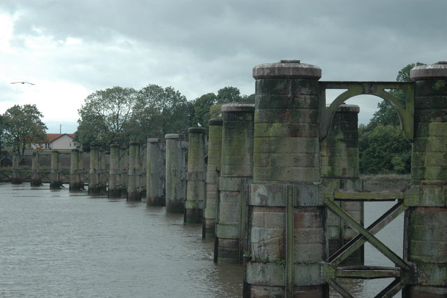
English: Forth Railway Bridge. The railway between Throsk and Alloa was authorised in 1879 as a branch from the Caledonian Railway's South Alloa branch, the CR absorbed the line in 1884 and it was closed from 6 May 1968. The photograph is from the middle of the river, we are passing through where the swing span was, and shows the southern part of the bridge. This bridge, until the opening of the Forth Bridge at Queensferry, was the most downstream bridge on the Forth. Latterly it was a somewhat rickety affair with a 10mph speed restriction and was used by a shuttle service between Larbert and Alloa operated by a 4 wheel diesel railbus although, in earlier years, there had been through Glasgow - Perth services via the Devon Valley. The bridge, by the way, is not shown on the OS 1/50000 map (!) but is on the Admiralty Charts, fortunately.
Français : Forth Railway Bridge. La construction de la voie ferrée entre Throsk et Alloa a été décidée en 1879 en tant que une branche de la section South Alloa du Caledonian Railway. Le CR a absorbé la ligne en 1884 et celle-ci fut fermée le 6 mai 1968. La photographie est prise du milieu de la rivière, à l'endroit où se trouvait la travée pivotante, et montre la partie sud du pont. Ce pont était le pont le plus en aval sur le Forth, jusqu'à l'ouverture du pont du Forth à Queensferry. |
| تاريخ | |
| مصدر | From geograph.org.uk |
| مؤلف | Gareth Foster |
| نسبه ل (required by the license) | Gareth Foster / Forth Railway Bridge / |
| موقع الكائن | | هذه وغيرها من الصور في مواقعها على: خريطة الشارع المفتوحة |
|---|
_&language=arz)
الترخيص

|
هذه الصُّورة مَأخُوذةٌ مِن مَجمُوعة مَشروع الجغرافيا. انظر صفحة هذه الصُّورة في موقع المَشروع للحصول على تفاصيل التَّواصل مع المُصوِّر. يَملك Gareth Foster حقوق التَّأليف والنَّشر لهذه الصُّورة، وهي مَنشُورة تحت رُخصة المشاع الإِبداعيِّ المُلزِمة بنسبة العمل إلى مؤلفه وبالمشاركة تحت الرُّخصة نفسها.
|
هذا الملف مُرخص تحت رخصة المشاع المبدع نسبة المصنف إلى مؤلفه - المشاركة على قدم المساواة 2.0 العامة
نسبه ل: Gareth Foster
- إنت حر:
- فى المشاركه – علشان نسخ و توزيع و بث العمل
- إنك تمزج – فى تكييف العمل
- بالشروط دى:
- نسبه ل – لازم يتنسب العمل للى مألفه بشكل مناسب و توفير رابط للرخصه وتحديد اذا حصلت تغييرات. ممكن ده يتعمل بأى طريقه معقوله، لكن مش بطريقه تشير ان مانح الرخصه بيوافقك على الاستعمال.
- مشاركه زي – لو عدت إنتاج المواد أو غيرت فيها، لازم تنشر مساهماتك اللى جايه من الأصل تحت ترخيص الأصل نفسه أو تحت ترخيص متوافق معاه.
تاريخ الفايل
اضغط على الساعه/التاريخ علشان تشوف الفايل زى ما كان فى الوقت ده.
| الساعه / التاريخ | صورة صغيرة | ابعاد | يوزر | تعليق | |
|---|---|---|---|---|---|
| دلوقتي | 15:25، 1 فبراير 2010 | | 640 × 426 (94 كيلوبايت) | GeographBot | == {{int:filedesc}} == {{Information |description={{en|1=Forth Railway Bridge. The railway between Throsk and Alloa was authorised in 1879 as a branch from the Caledonian Railway's South Alloa branch, the CR absorbed the line in 1884 and it was closed fro |
استخدام الفايل
ال2 صفحة دى فيها وصله للفايل ده:
استخدام الملف العام
الويكيات التانيه دى بتستخدم الفايل ده:
- الاستخدام ف en.wikipedia.org
- الاستخدام ف www.wikidata.org