الفرق بين النسختين بتاع: «هيسبانيولا»
تم حذف المحتوى تمت إضافة المحتوى
ص تمصير |
ص (GR) File renamed: File:La Española (orthographic projection).svg → File:Hispaniola (orthographic projection).svg File renaming criterion #2: To change from a meaningless or ambiguous name to a name... |
||
| سطر 3: | سطر 3: | ||
| image name = View of Haitian Landscape hispaniola.jpg |
| image name = View of Haitian Landscape hispaniola.jpg |
||
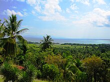
| image caption = View from Hispaniola |
| image caption = View from Hispaniola |
||
| locator map = |
| locator map = Hispaniola (orthographic projection).svg |
||
| map caption = |
| map caption = |
||
| nickname = |
| nickname = |
||
تعديلات من 20:49، 2 ديسمبر 2015
| La Española (Spanish) Ispayola (Haitian Creole) | |
|---|---|
 View from Hispaniola | |
 | |
| Geography | |
| Location | Caribbean |
| Archipelago | Greater Antilles |
| Area | 76,480 km2 (29,529 sq mi) |
| Area rank | 22nd |
| Coastline | 3,059 km (1,900.8 mi) |
| Highest elevation | 3,175 m (10,417 ft)[1] |
| Highest point | Pico Duarte |
| Political division | |
| Demographics | |
| Population | 18,943,000[2] (as of 2005) |
| Density | 241.5 /km2 (625.5 /sq mi) |
هيسبانيولا هيا جزيره من جزر الانتيل شرء كوبا وصلها كريستوفر كولمبوس يوم 5 ديسمبر 1492 م م و ف رحلته التانيه اسس فيها اول مستعمرة إسبانية ف العالم الجديد. تلت هيسبانيولا الغربى فيه هايتى و جمهورية الدومنيكان ف التلت الشرئى
