ملف:WestBengalDistricts numbered.svg

محتويات الصفحة غير مدعومة بلغات أخرى.
من ويكيبيديا، الموسوعه الحره

الصوره الاصليه(ملف SVG، اساسا 768 × 1,159 بكسل، حجم الملف: 311 كيلوبايت)

الملف دا من ويكيميديا كومنز و ممكن تستعمله المشاريع التانيه. الوصف بتاعه صفحة وصف الملف هناك معروض تحت..

الخلاصة

وصف
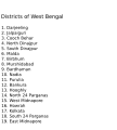
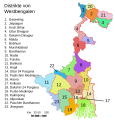
English: Original summary by creator of base svg file deeptrivia. Districts of West Bengal

Based on https://web.archive.org/web/20040606103522/www.censusindia.net/results/2001maps/wbengal01.html

Modifications by Mouryan:

  1. upladed translated version of File:WestBengalDistricts numbered de.svg.
  2. The districts of Dakshin 24 Parganas district and Uttar 24 Parganas were incorrectly numbered in the Map. The errors have been rectified.

Modifications by Furfur:

  1. The 4 (four) new districts of West Bengal namely Paschim Bardhaman district (bifurcated from Bardhaman district), Kalimpong district (bifurcated from Darjeeling district), Alipurduar district (bifurcated from Jalpaiguri district) and Jhargram district (bifurcated from Paschim Medinipur district) has been shown in this new Updated map.

Modifications by Antorjal:

  1. Midnapore District has been bifurcated to show both Paschim Medinipur and Purba Medinipur.
  2. Numbered and listed districts per comments at peer-review.
  3. Font size reduced for clarity, since the districts are now listed.
  4. Many of the spellings did not conform to linked articles in the text. All spellings now match the West Bengal article spellings.
تاريخ 8 اكتوبر 2006 (تاريخ الرفع الأصيل)
مصدر Transferred from en.wikipedia to Commons by Padawane.
مؤلف الرَّافِع الأصيل للملفِّ هو Antorjal في ويكيبيديا الإنجليزية.
إصدارات أخرى

[تعديل]

SVG منشأ الملف
InfoField
 
The source code of this SVG is invalid due to an error.
 
,هذا الرسم المتجهي أُنشئ بواسطة Adobe Illustrator
 
and with Inkscape.
 
 This map uses embedded text that can be easily translated using a text editor.

الترخيص

w:ar:مشاع إبداعي
نسبه ل مشاركه زي
هذا الملف مرخص تحت المشاع المبدع مؤلفه 2.5 عام, 2.0 عام and 1.0 عام الترخيص.
إنت حر:
  • فى المشاركه – علشان نسخ و توزيع و بث العمل
  • إنك تمزج – فى تكييف العمل
بالشروط دى:
  • نسبه ل – لازم يتنسب العمل للى مألفه بشكل مناسب و توفير رابط للرخصه وتحديد اذا حصلت تغييرات. ممكن ده يتعمل بأى طريقه معقوله، لكن مش بطريقه تشير ان مانح الرخصه بيوافقك على الاستعمال.
  • مشاركه زي – لو عدت إنتاج المواد أو غيرت فيها، لازم تنشر مساهماتك اللى جايه من الأصل تحت ترخيص الأصل نفسه أو تحت ترخيص متوافق معاه.
w:ar:مشاع إبداعي
نسبه ل مشاركه زي
الملف ده مترخص حسب رخصة المشاع الإبداعى نسبة المصنف للى مألفه - المشاركة بالمثل 3.0 العامه Subject to disclaimers.
إنت حر:
  • فى المشاركه – علشان نسخ و توزيع و بث العمل
  • إنك تمزج – فى تكييف العمل
بالشروط دى:
  • نسبه ل – لازم يتنسب العمل للى مألفه بشكل مناسب و توفير رابط للرخصه وتحديد اذا حصلت تغييرات. ممكن ده يتعمل بأى طريقه معقوله، لكن مش بطريقه تشير ان مانح الرخصه بيوافقك على الاستعمال.
  • مشاركه زي – لو عدت إنتاج المواد أو غيرت فيها، لازم تنشر مساهماتك اللى جايه من الأصل تحت ترخيص الأصل نفسه أو تحت ترخيص متوافق معاه.
تمت إضافة علامة الترخيص لهذا الملف كجزء من رخصة جنو للوثائق الحرة تحديث الترخيص.
GNU head يسمح بنسخ و توزيع و / أو تعديل الوثيقه دى تحت شروط رخصة جنو للوثائق الحره، الإصدار 1.2 أو أى إصدار تنشره مؤسسة البرمجيات الحره؛ بدون أقسام ثابته و بدون نصوص أغلفه أماميه و بدون نصوص أغلفه خلفيه. نسخه من الرخصه متضمنه ف قسم اسمه GNU Free Documentation License. Subject to disclaimers.

سجلُّ الرَّفع الأصيل

The original description page was here. All following user names refer to en.wikipedia.
  • 2006-12-25 04:28 Deeptrivia 450×500×0 (102714 bytes) Repair attempt
  • 2006-12-25 04:17 Deeptrivia 450×500×0 (101044 bytes) Repair attempt
  • 2006-10-08 14:21 Antorjal 450×500×0 (100501 bytes) Original summary by creator of base svg file [[User:deeptrivia|deeptrivia]]. Districts of West Bengal Based on http://web.archive.org/web/20040606103522/www.censusindia.net/results/2001maps/wbengal01.html Modifications by [[User:Antorjal|An
  • 2006-10-08 14:17 Antorjal 450×500×0 (100294 bytes) Original summary by creator of base svg file [[User:deeptrivia|deeptrivia]]. Districts of West Bengal Based on http://web.archive.org/web/20040606103522/www.censusindia.net/results/2001maps/wbengal01.html Modifications by [[User:Antorjal|An
  • 2006-10-08 14:15 Antorjal 450×500×0 (100501 bytes) Original summary by creator of base svg file [[User:deeptrivia|deeptrivia]]. Districts of West Bengal Based on http://web.archive.org/web/20040606103522/www.censusindia.net/results/2001maps/wbengal01.html Modifications by [[User:Antorjal|An
  • 2006-10-08 14:09 Antorjal 450×500×0 (100484 bytes) Original summary by creator of base svg file [[User:deeptrivia|deeptrivia]]. Districts of West Bengal Based on http://web.archive.org/web/20040606103522/www.censusindia.net/results/2001maps/wbengal01.html Modifications by [[User:Antorjal|An
  • 2006-10-08 14:05 Antorjal 450×500×0 (100501 bytes) Original summary by creator of base svg file [[User:deeptrivia|deeptrivia]]. Districts of West Bengal Based on http://web.archive.org/web/20040606103522/www.censusindia.net/results/2001maps/wbengal01.html Modifications by [[User:Antorjal|An

الشروحات

أضف شرحاً من سطر واحد لما يُمثِّله هذا الملف
West Bengal district

العناصر المصورة في هذا الملف

يُصوِّر العربية

8 اكتوبر 2006

نوع الوسائط العربية

image/svg+xml

تاريخ الفايل

اضغط على الساعه/التاريخ علشان تشوف الفايل زى ما كان فى الوقت ده.

الساعه / التاريخصورة صغيرةابعاديوزرتعليق
دلوقتي21:04، 25 ابريل 2020تصغير للنسخة بتاريخ 21:04، 25 ابريل 2020768 × 1,159 (311 كيلوبايت)Debjitpaul10Updated text
20:45، 25 ابريل 2020تصغير للنسخة بتاريخ 20:45، 25 ابريل 2020768 × 1,159 (113 كيلوبايت)Debjitpaul10Uploaded a corrected and transparent version.
06:15، 5 نوفمبر 2017تصغير للنسخة بتاريخ 06:15، 5 نوفمبر 2017576 × 601 (144 كيلوبايت)Mouryan{{Information |Description={{en|Original summary by creator of base svg file deeptrivia. Districts of West Bengal Based on http://web.archive.org/web/20040606103522/www.censusindia.net/results/2001maps/wbengal01.html Modificati...
02:51، 5 نوفمبر 2017تصغير للنسخة بتاريخ 02:51، 5 نوفمبر 2017576 × 601 (144 كيلوبايت)Mouryan{{Information |Description={{en|Original summary by creator of base svg file deeptrivia. Districts of West Bengal Based on http://web.archive.org/web/20040606103522/www.censusindia.net/results/2001maps/wbengal01.html Modificati...
13:59، 25 نوفمبر 2008تصغير للنسخة بتاريخ 13:59، 25 نوفمبر 20081,595 × 2,256 (212 كيلوبايت)GDibyendu{{Information |Description=fixed map (sunderbans), fixed district names |Source=based on locator map:West_Bengal_locator_map.svg |Date=2008-11-25 |Author=GDibyendu |Permission=All |other_versions= }}
20:30، 24 نوفمبر 2008تصغير للنسخة بتاريخ 20:30، 24 نوفمبر 2008450 × 500 (100 كيلوبايت)GDibyenduReverted to version as of 14:58, 17 January 2008 as some error crept in today's attempted upload
20:14، 24 نوفمبر 2008تصغير للنسخة بتاريخ 20:14، 24 نوفمبر 20081,595 × 2,256 (191 كيلوبايت)GDibyendu{{Information |Description=Corrected the map (it was not showing sunderbans are properly) |Source=This map is based on locator map of West Bengal (West_Bengal_locator_map.svg) |Date=2008-11-24 |Author=GDibyendu |Permission=All |other_versions= }}
17:43، 22 نوفمبر 2008تصغير للنسخة بتاريخ 17:43، 22 نوفمبر 2008450 × 500 (100 كيلوبايت)GDibyenduReverted to version as of 14:58, 17 January 2008
17:41، 22 نوفمبر 2008تصغير للنسخة بتاريخ 17:41، 22 نوفمبر 2008450 × 500 (7 كيلوبايت)GDibyendu{{Information |Description=Rewrote text in image to improve readability |Source=Based on last version |Date=2008-11-22 |Author=GDibyendu |Permission=All |other_versions= }}
14:58، 17 يناير 2008تصغير للنسخة بتاريخ 14:58، 17 يناير 2008450 × 500 (100 كيلوبايت)File Upload Bot (Magnus Manske) {{BotMoveToCommons|en.wikipedia}} {{Information |Description={{en|Original summary by creator of base svg file deeptrivia. Districts of West Bengal Based on http://web.archive.org/web/20040606103522/www.censusindia.net/results/200

مافيش صفحات بتوصل للفايل ده.

استخدام الملف العام

الويكيات التانيه دى بتستخدم الفايل ده:

اعرض استخدام عام اكتر للملف ده.

بيانات ميتا