
ملف:Viedma volcanic complex.jpg
مافيش ريزوليوشن اعلى متوفر.
Viedma_volcanic_complex.jpg (640 × 422 بكسل حجم الفايل: 64 كيلوبايت، نوع MIME: image/jpeg)
الخلاصة
| وصف |
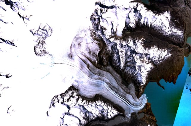
English: The figure-8-shaped area rising above the Patagonian Icefield at the upper left part of this NASA Landsat mosaic is part of the Viedma volcanic complex. An outflow glacier descends into Lake Viedma at the lower right. This mostly subglacial volcano produced an eruption in 1988 that confirmed the presence of a postulated subglacial vent in the Patagonian Icefield NW of Viedma Lake. The 1988 eruption deposited ash and pumice on the icecap and produced a mudflow that reached Viedma Lake. |
| تاريخ | تاريخ مش معروف |
| مصدر | http://www.volcano.si.edu/world/volcano.cfm?vnum=1508-061&volpage=photos&photo=115011 |
| مؤلف | NASA Landsat7 image (worldwind.arc.nasa.gov) |
الترخيص
| هذه الصُّورة في النِّطاق العامِّ لأنها لقطة شاشةٍ مِن تطبيق وُرد ويند الخاصِّ بوكالة الفضاء الأمريكيَّة مأخوذةٌ مِن نمطٍ يَستعمل طَبقةً مَوجُودةً في النِّطاق العامِّ أساساً.
|
 |
تاريخ الفايل
اضغط على الساعه/التاريخ علشان تشوف الفايل زى ما كان فى الوقت ده.
| الساعه / التاريخ | صورة صغيرة | ابعاد | يوزر | تعليق | |
|---|---|---|---|---|---|
| دلوقتي | 15:37، 15 اكتوبر 2010 | | 640 × 422 (64 كيلوبايت) | Michael Metzger | {{Information |Description={{en|1= The figure-8-shaped area rising above the Patagonian Icefield at the upper left part of this NASA Landsat mosaic is part of the Viedma volcanic complex. An outflow glacier descends into Lake Viedma at the lower right. Th |
استخدام الفايل
ال1 صفحة دى فيها وصله للفايل ده:
استخدام الملف العام
الويكيات التانيه دى بتستخدم الفايل ده:
- الاستخدام ف cs.wikipedia.org
- الاستخدام ف de.wikipedia.org
- الاستخدام ف en.wikipedia.org
- الاستخدام ف es.wikipedia.org
- الاستخدام ف fr.wikipedia.org
- الاستخدام ف pt.wikipedia.org
- الاستخدام ف sk.wikipedia.org
- الاستخدام ف uk.wikipedia.org
- الاستخدام ف www.wikidata.org