
ملف:The Edinburgh Dome - geograph.org.uk - 303213.jpg
مافيش ريزوليوشن اعلى متوفر.
The_Edinburgh_Dome_-_geograph.org.uk_-_303213.jpg (640 × 435 بكسل حجم الفايل: 236 كيلوبايت، نوع MIME: image/jpeg)
الخلاصة
| وصف |
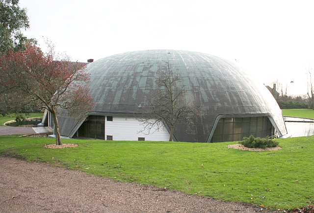
English: The Edinburgh Dome, Imperial Road, Malvern, Worcestershire. The building belongs to Malvern St James School and was built as a sports hall. It was named after the Duke of Edinburgh who opened it in 1978. The sports hall has now moved to a new one on Barnards Green Road. In 2006 the school applied for planning permission to demolish the dome but was turned down. In 2009 the Department of Culture, Media and Sport made the dome a Grade II listed building.
The dome is a concrete parashell and is the only one in the country. It was built by a pioneering technique in which liquid cement was poured onto a special neoprene membrane and then pneumatically inflated; in this case to a height of 11 metres. It took just an hour to complete the inflation and two weeks to complete the building. A moat was built around the base and openings made for doors, windows and for light to reflect off the surrounding water to light the inside of the dome. The parashell was invented by an Italian, Dante Bini, in 1967. The architects here were Godwin and Cowper of Stourport. The construction technique appeared simple, but in fact required a great deal of meticulous planning and seemingly a good deal of luck, which perhaps explains why this structure is still unique in the UK! |
| تاريخ | |
| مصدر | From geograph.org.uk |
| مؤلف | Bob Embleton |
| نسبه ل (required by the license) | Bob Embleton / The Edinburgh Dome / |
| موقع الكاميرا | | هذه وغيرها من الصور في مواقعها على: خريطة الشارع المفتوحة |
|---|
_heading:135.00&language=arz)
| موقع الكائن | | هذه وغيرها من الصور في مواقعها على: خريطة الشارع المفتوحة |
|---|
_heading:135.00&language=arz)
الترخيص

|
هذه الصُّورة مَأخُوذةٌ مِن مَجمُوعة مَشروع الجغرافيا. انظر صفحة هذه الصُّورة في موقع المَشروع للحصول على تفاصيل التَّواصل مع المُصوِّر. يَملك Bob Embleton حقوق التَّأليف والنَّشر لهذه الصُّورة، وهي مَنشُورة تحت رُخصة المشاع الإِبداعيِّ المُلزِمة بنسبة العمل إلى مؤلفه وبالمشاركة تحت الرُّخصة نفسها.
|
هذا الملف مُرخص تحت رخصة المشاع المبدع نسبة المصنف إلى مؤلفه - المشاركة على قدم المساواة 2.0 العامة
نسبه ل: Bob Embleton
- إنت حر:
- فى المشاركه – علشان نسخ و توزيع و بث العمل
- إنك تمزج – فى تكييف العمل
- بالشروط دى:
- نسبه ل – لازم يتنسب العمل للى مألفه بشكل مناسب و توفير رابط للرخصه وتحديد اذا حصلت تغييرات. ممكن ده يتعمل بأى طريقه معقوله، لكن مش بطريقه تشير ان مانح الرخصه بيوافقك على الاستعمال.
- مشاركه زي – لو عدت إنتاج المواد أو غيرت فيها، لازم تنشر مساهماتك اللى جايه من الأصل تحت ترخيص الأصل نفسه أو تحت ترخيص متوافق معاه.
تاريخ الفايل
اضغط على الساعه/التاريخ علشان تشوف الفايل زى ما كان فى الوقت ده.
| الساعه / التاريخ | صورة صغيرة | ابعاد | يوزر | تعليق | |
|---|---|---|---|---|---|
| دلوقتي | 22:42، 22 ديسمبر 2010 | | 640 × 435 (236 كيلوبايت) | GeographBot | == {{int:filedesc}} == {{Information |description={{en|1=The Edinburgh Dome The Edinburgh Dome, off Imperial Road, is owned by Malvern St James School and was built as a sports hall. It was named after the Duke of Edinburgh who opened it in 1978. The spor |
استخدام الفايل
ال1 صفحة دى فيها وصله للفايل ده:
استخدام الملف العام
الويكيات التانيه دى بتستخدم الفايل ده:
- الاستخدام ف fr.wikipedia.org
- الاستخدام ف nl.wikipedia.org