
ملف:Satellite image of France in August 2002.jpg

حجم البروفه دى: 780 × 600 بكسل. الأبعاد التانيه: 312 × 240 بكسل | 624 × 480 بكسل | 999 × 768 بكسل | 1,280 × 985 بكسل | 2,560 × 1,969 بكسل | 5,200 × 4,000 بكسل.
الصوره الاصليه (5,200 × 4,000 بكسل حجم الفايل: 3.75 ميجابايت، نوع MIME: image/jpeg)
| وصف |
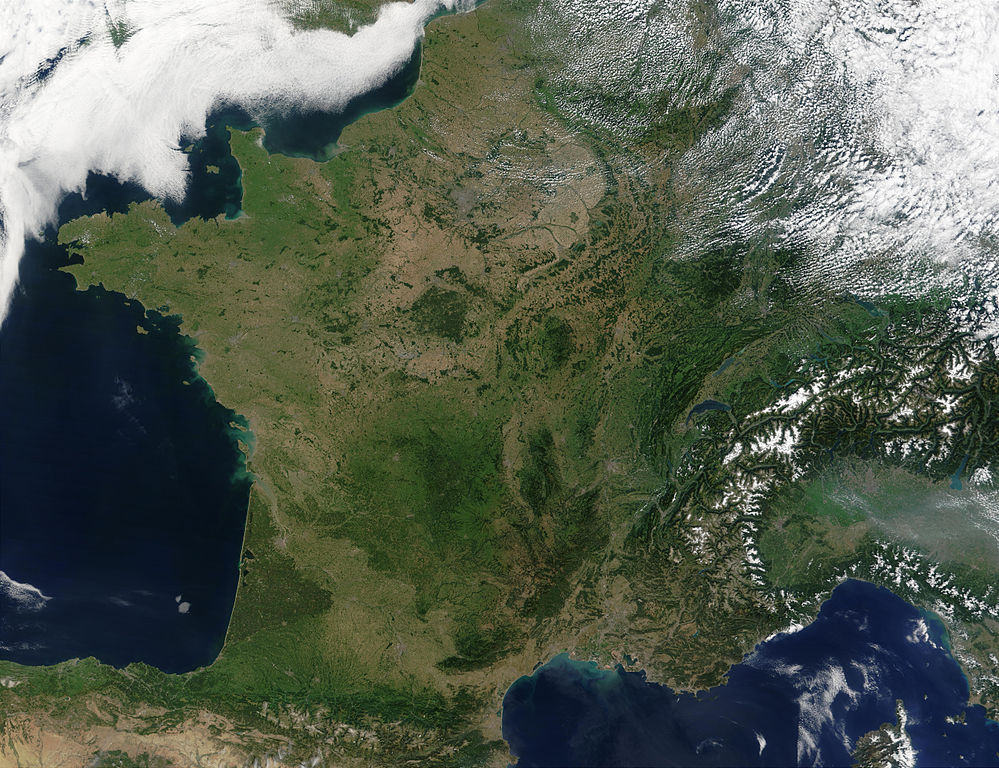
English: Satellite image of France acquired August 14, 2002, by the Terra satellite.
Suomi: Satelliittikuva Ranskasta elokuussa 2002 |
| تاريخ | |
| مصدر |
Slightly cropped image. Original taken from NASA's Visible Earth: [1]. Credit: Jacques Descloitres, MODIS Rapid Response Team, NASA/GSFC |
| مؤلف | Jacques Descloitres, MODIS Rapid Response Team, NASA/GSFC |
| يقع هذا العمل في النِّطاق العامّ في الولايات المُتحدة الأمريكيَّة لأَنَّه عملٌ خالِصٌ من إِنتاج وكالة الفضاء الأمريكيَّة. تنصُ حقوق التَّأليف والنَّشر الخاصَّة بوكالة الفضاء الأمريكيَّة على أنَّ "أعمال الوكالة غير مَحميَّة بحقوق التَّأليف والنَّشر ما لم يُذكر خلافُ ذلك". لمزيدٍ من المعلومات انظر القالِب {{PD-USGov}} وصفحة حقوق التَّأليف والنَّشر الخاصَّة بالوكالة وصفحة سياسة الصُّور الخاصَّة بمُختبر الدَّفع النَّفَّاث. | ||
 |
تنبيهات:
|
This image was selected as picture of the day on Wikimedia Commons for 4 May 2005. It was captioned as follows: English: France from space Other languages:
Ænglisc: Francland gesewen of woruldrúme 閩南語 / Bân-lâm-gú: Tùi thài-khong khoàⁿ Hoat-kok. Català: França des de l'espai. Čeština: Francie při pohledu z vesmíru Cymraeg: Frainc o'r gofod. Deutsch: Frankreich aus dem Weltraum gesehen English: France from space Français : La France vue de l'espace. Galego: Francia Italiano: La Francia vista dal satellite. Nederlands: Frankrijk vanuit de ruimte. Norsk bokmål: Frankrike fra rommet Polski: Francja z kosmosu Slovenčina: Francúzsko pri pohľade z vesmíru Suomi: Elokuinen manner-Ranska satelliittikuvassa Svenska: Satellitbild på Frankrike Беларуская: Францыя з космасу Български: Франция от космоса Русский: Франция из космоса ไทย: ประเทศฝรั่งเศสเมื่อมองจากอวกาศ 한국어: 우주에서 바라본 프랑스 日本語: 宇宙から見たフランス 中文: 法国卫星照片 |
تاريخ الفايل
اضغط على الساعه/التاريخ علشان تشوف الفايل زى ما كان فى الوقت ده.
| الساعه / التاريخ | صورة صغيرة | ابعاد | يوزر | تعليق | |
|---|---|---|---|---|---|
| دلوقتي | 10:50، 15 يناير 2008 | | 5,200 × 4,000 (3.75 ميجابايت) | Kyle the hacker | uncropped, better definited version |
| 12:30، 8 مارس 2005 |  | 3,930 × 3,965 (2.82 ميجابايت) | Hautala | {{PD-USGov-NASA}} Satellite image of France in August 2002. Slightly cropped image. Original taken from NASA's Visible Earth, http://visibleearth.nasa.gov/view_rec.php?id=4202 . |
استخدام الفايل
مافيش صفحات بتوصل للفايل ده.
استخدام الملف العام
الويكيات التانيه دى بتستخدم الفايل ده:
- الاستخدام ف af.wikipedia.org
- الاستخدام ف an.wikipedia.org
- الاستخدام ف ar.wikipedia.org
- بولا جاك
- جاك كفالييه
- شارل ديدييه
- نيكيز أوغست ديفو
- جون باتيست تشارلز لوكاس
- لوي لو برانس
- دانييل أوبيه
- جويمي دوفاي
- أوجين سكرايب
- آلان بوهر
- سوفانوفونج
- أندريه جيلفي
- ميشيل دوك جونناز
- موريل كاسالز
- فيوليت فيردي
- ماريون تورنو-برانلي
- الكسندر استروك
- لويس جوردان
- باتاشو
- آلان رينيه
- كريستوف دو مارجري
- برناديت لافون
- كلود ميلر
- كلود ليلوش
- كارول بوكيه
- فاني اردانت
- انوك ايمي
- بياتريس دالي
- جان جيرو
- تشارلز بيرلنج
- أرنولد فان شينب
- الين بومبارد
- جان فرانسوا دينيو
- جان بول روسيون
- دينيس بوداليدس
- باتريس شيرو
- فرانسوا دو لاروشفوكو
- بيرتراند كونت تولوز
- شارل ستوبين
- غاستون كاستل
- إدموند دولاك
- أوغستين فيليكس فورتين
- جان باتيست هنري
- جان جيلبرت
- جان فنتوريني
- لوران دو لا هير
اعرض استخدام عام اكتر للملف ده.