
ملف:Pestilence spreading 1347-1351 europe.png

الصوره الاصليه (1,280 × 1,387 بكسل حجم الفايل: 350 كيلوبايت، نوع MIME: image/png)
| وصف |
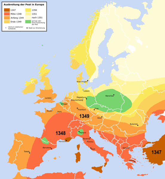
English: Spreading of the en:Black Death in Europe between 1347 and 1351, apparently copied from a work called "Atlas zur Weltgeschichte" (perhaps dtv-Atlas? If so, Kinder and Hilgemann (eds.), dtv-Atlas zur Weltgeschichte was published in 35(!) editions between 1964 and 2002, and it would be crucial to know which edition we are basing this on).
The details of the map are to be taken with a large grain of salt. It is roughly compatible with this Britannica map (copy, dated 1994), but the details vary significantly. Other significant differences exist with this map (an unreferenced scan of a professional publication), where e.g. the area of Poland/Silesia marked "unaffected" in this map is part of a much larger area marked as "Area for which there is insufficient information". Here is another map with a somewhat more conservative epistemology, referenced to "insecta-inspecta.com", where it was posted in 2000 (and therefore uninfluenced by the 2005 upload of this map). An academically published map for comparison: [1] cited to: D. Sherman and J. Salisbury, The West in the World: Volume I to 1715. McGraw-Hill, Boston, 3rd edition (2008), not necessarily better than the Britannica map, as it is a rough sketched used for the purposes of some argument about network theory, and not a medievalist publication dedicated to the history of the Black Death as such.Deutsch: Ausbreitung der de:Pest in Europa zwischen 1347 und 1351 |
| تاريخ | |
| مصدر | "Atlas zur Weltgeschichte"(?) |
| مؤلف | Roger_Zenner |
| سماح (إعادة استخدام الملف ده) |
Creative Commons by/sa/de |
| إصدارات أخرى |
[]
|


- Version 1.1
- Changelog: 1.0: new map -> 1.1: more details, color changes, more cities
- إنت حر:
- فى المشاركه – علشان نسخ و توزيع و بث العمل
- إنك تمزج – فى تكييف العمل
- بالشروط دى:
- نسبه ل – لازم يتنسب العمل للى مألفه بشكل مناسب و توفير رابط للرخصه وتحديد اذا حصلت تغييرات. ممكن ده يتعمل بأى طريقه معقوله، لكن مش بطريقه تشير ان مانح الرخصه بيوافقك على الاستعمال.
- مشاركه زي – لو عدت إنتاج المواد أو غيرت فيها، لازم تنشر مساهماتك اللى جايه من الأصل تحت ترخيص الأصل نفسه أو تحت ترخيص متوافق معاه.

تاريخ الفايل
اضغط على الساعه/التاريخ علشان تشوف الفايل زى ما كان فى الوقت ده.
| الساعه / التاريخ | صورة صغيرة | ابعاد | يوزر | تعليق | |
|---|---|---|---|---|---|
| دلوقتي | 22:42، 3 ابريل 2016 | | 1,280 × 1,387 (350 كيلوبايت) | Poeticbent | made the map readable again |
| 01:32، 24 مايو 2015 |  | 1,280 × 1,387 (330 كيلوبايت) | Alphathon | Removed border in Northern Serbia (seems roughly correspond to the Autonomous Province of Vojvodina; shouldn't be on there regardless). Added border between Montenegro and Serbia (which separated in 2006). Also added Kosovo border. | |
| 13:18، 21 يناير 2010 |  | 1,280 × 1,387 (304 كيلوبايت) | Chesnok | deleted artificial Rybinsk reservoir and reservoirs on Dnieper | |
| 03:46، 3 ابريل 2005 |  | 1,280 × 1,387 (378 كيلوبايت) | Roger Zenner | ||
| 03:30، 3 ابريل 2005 |  | 1,280 × 1,354 (394 كيلوبايت) | Roger Zenner | ||
| 02:17، 3 ابريل 2005 |  | 1,280 × 1,346 (373 كيلوبايت) | Roger Zenner | *'''english''': spreading of the en:pest in Europe between 1347 and 1351 *'''deutsch''': Ausbreitung der de:Pest in Europa zwischen 1347 und 1351 *License: Creative Commons by/sa/de *Author: Roger_Zenner *Date: 2005/03/04 |
استخدام الفايل
ال1 صفحة دى فيها وصله للفايل ده:
استخدام الملف العام
الويكيات التانيه دى بتستخدم الفايل ده:
- الاستخدام ف als.wikipedia.org
- الاستخدام ف an.wikipedia.org
- الاستخدام ف azb.wikipedia.org
- الاستخدام ف bg.wikipedia.org
- الاستخدام ف cy.wikipedia.org
- الاستخدام ف de.wikipedia.org
- الاستخدام ف de.wikibooks.org
- الاستخدام ف frr.wikipedia.org
- الاستخدام ف fr.wikipedia.org
- الاستخدام ف gl.wikipedia.org
- الاستخدام ف hu.wikipedia.org
- الاستخدام ف hy.wikipedia.org
- الاستخدام ف ia.wikipedia.org
- الاستخدام ف incubator.wikimedia.org
- الاستخدام ف io.wikipedia.org
- الاستخدام ف lad.wikipedia.org
- الاستخدام ف la.wikipedia.org
- الاستخدام ف nl.wikipedia.org
- الاستخدام ف sl.wikipedia.org
- الاستخدام ف www.wikidata.org
- الاستخدام ف zh-min-nan.wikipedia.org