
ملف:NepalRupandehiDistrictmap.png
الصوره الاصليه (3,508 × 2,479 بكسل حجم الفايل: 319 كيلوبايت، نوع MIME: image/png)
الخلاصة
| وصف |
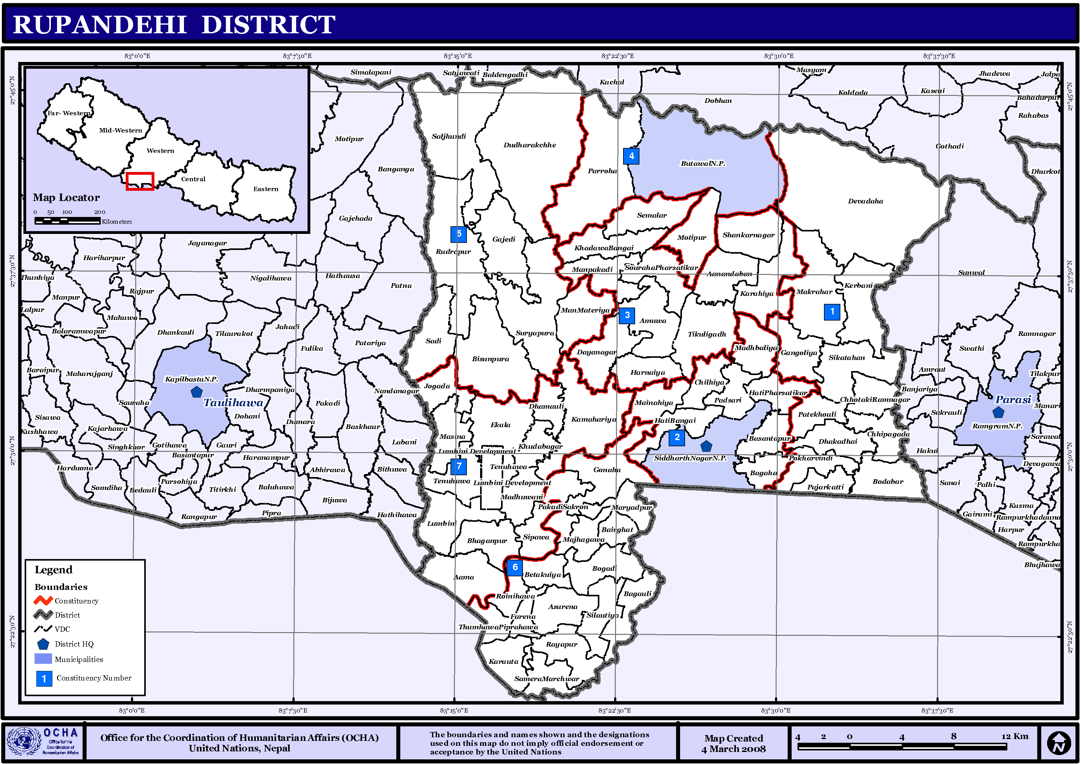
English: Map displaying Village Development Committees in Rupandehi District, Nepal |
| تاريخ | |
| مصدر | http://www.un.org.np/maps/district-maps/western/Rupandehi.pdf |
| مؤلف | United Nations |
الترخيص
| This image is a map derived from a United Nations map.
Unless stated otherwise, UN maps are to be considered in the public domain. This applies worldwide. UN maps are, in principle, open source material and you can use them in your work or for making your own map. UN requests however that you delete the UN name, logo and reference number upon any modification to the map. Content of your map will be your responsibility. You can state in your publication, if you wish, something like: based on UN map … (map name, map number, revision number and date). See: Geospatial Information Section. And: Geospatial, location data for a better world. |
 |
تاريخ الفايل
اضغط على الساعه/التاريخ علشان تشوف الفايل زى ما كان فى الوقت ده.
| الساعه / التاريخ | صورة صغيرة | ابعاد | يوزر | تعليق | |
|---|---|---|---|---|---|
| دلوقتي | 13:55، 13 نوفمبر 2008 | | 3,508 × 2,479 (319 كيلوبايت) | Sadalmelik | == Summary == {{Information |Description={{en|1=Map displaying Village Development Committees in Rupandehi District, Nepal}} |Source=http://www.un.org.np/maps/district-maps/western/Rupandehi.pdf |Date=March 4, 2008 |Author=United Nations |Permission= |
استخدام الفايل
ال1 صفحة دى فيها وصله للفايل ده:
استخدام الملف العام
الويكيات التانيه دى بتستخدم الفايل ده:
- الاستخدام ف awa.wikipedia.org
- असुरैना
- आमा गाविस
- कम्हरिया
- करौता
- खवनगाइ
- गंगोलिया
- गजेडी
- गोनाहा
- चिल्हिया
- छिपागढ
- छोरामनगर
- जोगडा
- तिलोत्तमा नगरपालिका
- थु.पिपरवहा
- दयानगर
- देवदह नगरपालिका
- धकधइ
- धमोली
- प. अमुवा
- पजरकट्टी
- पटखौली
- पडसरी
- पोखरभिण्डी
- फरेना
- बसन्तपुर, रुपन्देही
- बुटवल उपमहानगरपालिका
- बैरघाट
- बोदवार
- मझगावा
- मनहिया
- मर्यादपुर, रुपन्देही
- मान पकडी
- मानमटेरिया
- रायपुरा
- रुद्रपुर
- रोइनिहवा
- लुम्बिनी सांस्कृतिक नगरपालिका
- वगाह
- वगौली
- विष्णुपुरा
- वेतकुइया
- वोगडी
- सक्रौनपकडी
- साडी गाविस
- सालझण्डी
- सिक्टहन
- सिपवा
- सिलौटिया
- सूर्यपुरा
- सेमरा मर्चवार
اعرض استخدام عام اكتر للملف ده.