
ملف:Map of Kentucky highlighting Washington County.svg

حجم معاينة PNG لذلك الملف ذي الامتداد SVG: 800 × 345 بكسل. الأبعاد التانيه: 320 × 138 بكسل | 640 × 276 بكسل | 1,024 × 441 بكسل | 1,280 × 551 بكسل | 2,560 × 1,103 بكسل | 6,770 × 2,916 بكسل.
الصوره الاصليه (ملف SVG، اساسا 6,770 × 2,916 بكسل، حجم الملف: 127 كيلوبايت)
الخلاصة
| وصف |
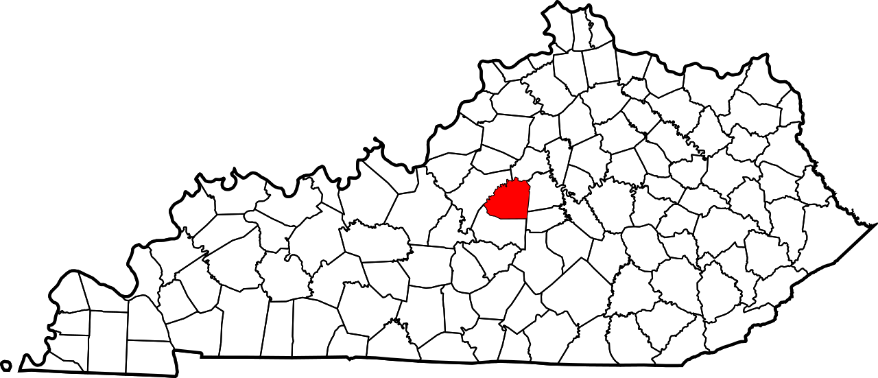
English: This is a locator map showing Washington County in Kentucky. For more information, see Commons:United States county locator maps. |
| تاريخ | |
| مصدر |
عمل شخصى: English: The maps use data from nationalatlas.gov, specifically countyp020.tar.gz on the Raw Data Download page. The maps also use state outline data from statesp020.tar.gz. The Florida maps use hydrogm020.tar.gz to display Lake Okeechobee. |
| مؤلف | David Benbennick |
الترخيص
| أنا، مالِك حقوق تأليف ونشر هذا العمل، أجعله في النِّطاق العامِّ، يسري هذا في أرجاء العالم كلِّه. في بعض البلدان، قد يكون هذا التَّرخيص غيرَ مُمكنٍ قانونيَّاً، في هذه الحالة: أمنح الجميع حق استخدام هذا العمل لأي غرض دون أي شرط ما لم يفرض القانون شروطًا إضافية. |
تاريخ الفايل
اضغط على الساعه/التاريخ علشان تشوف الفايل زى ما كان فى الوقت ده.
| الساعه / التاريخ | صورة صغيرة | ابعاد | يوزر | تعليق | |
|---|---|---|---|---|---|
| دلوقتي | 12:25، 12 فبراير 2006 | | 6,770 × 2,916 (127 كيلوبايت) | David Benbennick | {{subst:User:Dbenbenn/clm|county=Washington County|state=Kentucky}} |
استخدام الفايل
ال1 صفحة دى فيها وصله للفايل ده:
استخدام الملف العام
الويكيات التانيه دى بتستخدم الفايل ده:
- الاستخدام ف ar.wikipedia.org
- الاستخدام ف bg.wikipedia.org
- الاستخدام ف bpy.wikipedia.org
- الاستخدام ف cdo.wikipedia.org
- الاستخدام ف ceb.wikipedia.org
- الاستخدام ف ce.wikipedia.org
- الاستخدام ف cy.wikipedia.org
- الاستخدام ف de.wikipedia.org
- الاستخدام ف en.wikipedia.org
- Washington County, Kentucky
- Mackville, Kentucky
- Springfield, Kentucky
- Willisburg, Kentucky
- Manton, Kentucky
- List of counties in Kentucky
- Beech Fork
- Willisburg Lake
- Chaplin River
- Bearwallow, Kentucky
- Template:Washington County, Kentucky
- User:Nyttend/County templates/KY/2
- National Register of Historic Places listings in Washington County, Kentucky
- Fredericktown, Kentucky
- Category:Populated places in Washington County, Kentucky
- Brush Grove, Kentucky
- Maud, Kentucky
- Mooresville, Kentucky
- Saint Catharine, Kentucky
- Template:WashingtonCountyKY-geo-stub
- Texas, Kentucky
- الاستخدام ف eo.wikipedia.org
- الاستخدام ف es.wikipedia.org
- الاستخدام ف et.wikipedia.org
- الاستخدام ف eu.wikipedia.org
- الاستخدام ف fa.wikipedia.org
اعرض استخدام عام اكتر للملف ده.