
ملف:Liechtenstein topographic map-de Version Tschubby.png

حجم البروفه دى: 458 × 599 بكسل. الأبعاد التانيه: 183 × 240 بكسل | 367 × 480 بكسل | 587 × 768 بكسل | 783 × 1,024 بكسل | 2,189 × 2,862 بكسل.
الصوره الاصليه (2,189 × 2,862 بكسل حجم الفايل: 2.2 ميجابايت، نوع MIME: image/png)
الخلاصة
| وصف |
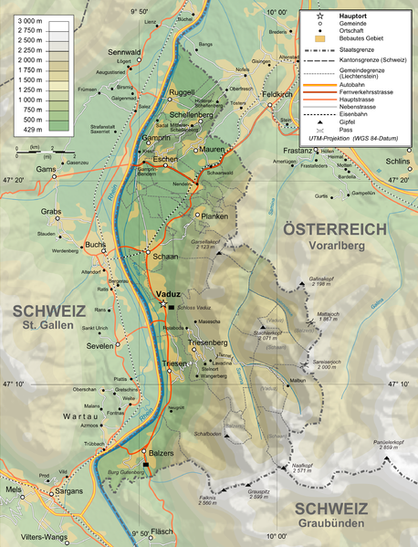
Deutsch: Topographische Karte von Liechtenstein, deutsche Version English: Topographic map in German of Liechtenstein Français : Carte topographique en allemand du Liechtenstein |
| تاريخ | |
| مصدر |
English: Own work ; Topographic data from the NASA Shuttle Radar Topography Mission (SRTM3 v.2) (public domain) edited with 3DEM and dlgv32 Pro, and vectorized with Inkscape ; UTM projection ; WGS84 datum ; shaded relief (N-W lightning positions) edited with The Gimp ; Reference used for the additional data : * Rivers, cities, railroads, routes, bathymetry : Demis add-on for World Wind (see the approval e-mail and the Demis forum) ; * Borders and coast : World data bank II + + File:Liechtenstein-admin.png by user:Aotearoa ; Approximate scale of topographic data : 1:1,463,000 ; Note : The shaded relief is a raster image embedded in the SVG file. Français : Création personnelle ; Données topographiques de la NASA Shuttle Radar Topography Mission (SRTM3 v.2) (domaine public) éditées avec 3DEM etdlgv32 Pro, et vectorisées avec Inkscape ; projection UTM ; WGS84 datum ; relief ombré (éclairage du N-O) édité avec The Gimp ; Références utilisées pour les données complémentaires : * Rivières, villes, chemins de fers, routes, bathymétrie : Demis add-on for World Wind (cf. l'e-mail d'approbation de Demis et le Demis forum) ; * Frontières et côtes : World data bank II + File:Liechtenstein-admin.png de user:Aotearoa ; Échelle approximative des données topographiques : 1:1 463 000 ; Note : Le relief ombré est une image bitmap embarquée dans le fichier SVG. Approximate geographic limits of the map (30" close) : * SW corner : 47°02'05"N – 9°40'00"E * SE corner : 47°02'05"N – 9°70'00"E * NE corner : 47°27'55"N – 9°70'00"E * NW corner : 47°27'55"N – 9°40'00"E |
| مؤلف | Bourrichon, translated by NordNordWest, new Design by Tschubby |
| سماح (إعادة استخدام الملف ده) |
GFDL / Attribution and Share-Alike required |
| إصدارات أخرى |
|


الترخيص
أنا، صاحب حقوق التأليف والنشر لهذا العمل، أنشر هذا العمل تحت الرخص التالية:

|
يسمح بنسخ و توزيع و / أو تعديل الوثيقه دى تحت شروط رخصة جنو للوثائق الحره، الإصدار 1.2 أو أى إصدار تنشره مؤسسة البرمجيات الحره؛ بدون أقسام ثابته و بدون نصوص أغلفه أماميه و بدون نصوص أغلفه خلفيه. نسخه من الرخصه متضمنه ف قسم اسمه GNU Free Documentation License. |
This file is licensed under the Creative Commons Attribution-Share Alike 4.0 International, 3.0 Unported, 2.5 Generic, 2.0 Generic and 1.0 Generic license.
- إنت حر:
- فى المشاركه – علشان نسخ و توزيع و بث العمل
- إنك تمزج – فى تكييف العمل
- بالشروط دى:
- نسبه ل – لازم يتنسب العمل للى مألفه بشكل مناسب و توفير رابط للرخصه وتحديد اذا حصلت تغييرات. ممكن ده يتعمل بأى طريقه معقوله، لكن مش بطريقه تشير ان مانح الرخصه بيوافقك على الاستعمال.
- مشاركه زي – لو عدت إنتاج المواد أو غيرت فيها، لازم تنشر مساهماتك اللى جايه من الأصل تحت ترخيص الأصل نفسه أو تحت ترخيص متوافق معاه.
اختار الرخصه اللى تناسبك.
تاريخ الفايل
اضغط على الساعه/التاريخ علشان تشوف الفايل زى ما كان فى الوقت ده.
| الساعه / التاريخ | صورة صغيرة | ابعاد | يوزر | تعليق | |
|---|---|---|---|---|---|
| دلوقتي | 14:05، 3 فبراير 2016 | | 2,189 × 2,862 (2.2 ميجابايت) | RokerHRO | optipng -o7 -zm1-9 -i0 → 48.70% decrease |
| 11:37، 12 فبراير 2012 |  | 2,189 × 2,862 (4.3 ميجابايت) | Tschubby | {{Information |Description= |Source= |Date= |Author= |Permission= |other_versions= }} | |
| 11:31، 12 فبراير 2012 |  | 2,189 × 2,862 (8.6 ميجابايت) | Tschubby | {{Information |Description= |Source= |Date= |Author= |Permission= |other_versions= }} | |
| 16:17، 26 يناير 2012 |  | 1,305 × 1,683 (2.3 ميجابايت) | Tschubby | {{Information |Description= |Source= |Date= |Author= |Permission= |other_versions= }} | |
| 16:13، 26 يناير 2012 |  | 794 × 1,024 (1.26 ميجابايت) | Tschubby | {{Information |Description= |Source= |Date= |Author= |Permission= |other_versions= }} | |
| 09:05، 21 يوليه 2009 |  | 1,305 × 1,683 (1.46 ميجابايت) | Tschubby | {{Information |Description= |Source= |Date= |Author= |Permission= |other_versions= }} | |
| 08:50، 21 يوليه 2009 |  | 1,338 × 1,683 (1.48 ميجابايت) | Tschubby | == Summary == {{Information |Description={{de|Topographische Karte von Liechtenstein, deutsche Version}}{{en|Topographic map in German of Liechtenstein}}{{fr|Carte topographique en allemand du [[:fr:Liechtenstei |
استخدام الفايل
مافيش صفحات بتوصل للفايل ده.
استخدام الملف العام
الويكيات التانيه دى بتستخدم الفايل ده:
- الاستخدام ف af.wikipedia.org
- الاستخدام ف als.wikipedia.org
- الاستخدام ف de.wikipedia.org
- الاستخدام ف es.wikipedia.org
- الاستخدام ف fo.wikipedia.org
- الاستخدام ف frr.wikipedia.org
- الاستخدام ف pdc.wikipedia.org
- الاستخدام ف pfl.wikipedia.org
- الاستخدام ف rm.wikipedia.org