
ملف:FortHarmar.jpg

الصوره الاصليه (837 × 489 بكسل حجم الفايل: 114 كيلوبايت، نوع MIME: image/jpeg)
الخلاصة
| وصف |
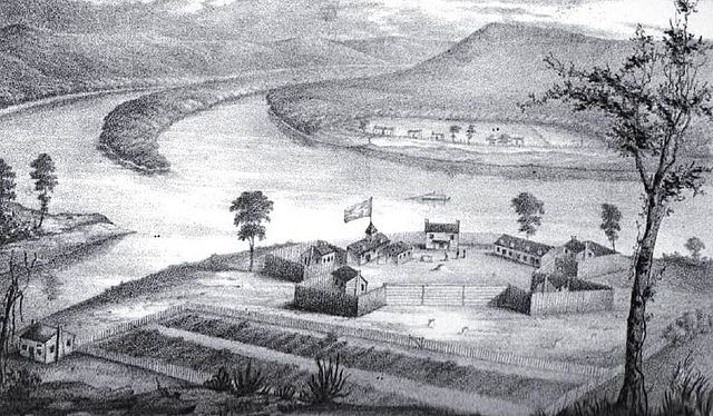
English: Fort Harmar, constructed in the autumn of 1785 at the confluence of the Ohio and Muskingum rivers, on the west side of the mouth of the Muskingum River. “The position was judiciously chosen, as it commanded not only the mouth of the Muskingum, but swept the waters of the Ohio, from a curve in the river for a considerable distance both above and below the fort.” The view of the image is looking forward towards the Ohio, with the mouth of the Muskingum on the left; in the background, across the Ohio River, are houses of the settlement that would later become Williamstown. Buckley Island is located to the upper left in the Ohio River.
The Campus Martius fortification of the Marietta settlement was built on the east side of the Muskingum and upriver from Fort Harmar during 1788, and fully completed in 1791 at the start of the Northwest Indian War. The Picketed Point fortification of Marietta was built directly across the Muskingum from Fort Harmar, on the east side of the mouth, during 1791. Image and quote from the book by S. P. Hildreth: Pioneer History: Being an Account of the First Examinations of the Ohio Valley, and the Early Settlement of the Northwest Territory, H. W. Derby and Co., Cincinnati, Ohio (1848). Illustration plate located between pp. 316-17.
|
| تاريخ | قبل 1806 |
| مصدر | Hildreth, S. P. (1848) Pioneer History: Being an Account of the First Examinations of the Ohio Valley, and the Early Settlement of the Northwest Territory، سينسيناتى: H. W. Derby and Co، p. 316 1/2 |
| مؤلف | Judge Joseph Gilman (1738-1806) |
الترخيص
يقع ملفُ الوسائط هذا في النِّطاق العامّ داخل الولايات المُتحدة الأمريكيَّة. وهذا ينطبق على الأعمال أمريكيَّة الأصل التي نفدت مدة حقوق تأليفها ونشرها، وهذا في الغالب الأعم عائدٌ إلى نشرها للمرة الأولى مرة قبل 1 يناير، ١٩٢٩. راجع هذه الصفحة للمزيد من التوضيح.
|
 | |
 |
قد لا تكون هذه الصورة في النِّطاق العامّ من خارج الولايات المُتحدة، وهذا ينطبق بشكلٍ خاصٍّ في البلدان والمناطق التي لا يكون حكم الفترة الأقصر فيها نافذاً على الأعمال الأمريكية، مثل كندا وجمهورية الصين (ما خلا هونغ كونغ وماكاو) وألمانيا والمكسيك وسويسرا. إنَّ اسم المُؤَلِّف وسنة النشر هما من المعلومات الأساسيَّة، ولا بدَ من ذكرهما. انظر ويكيبيديا:الملكية العامة وويكيبيديا:حقوق التأليف والنشر للمزيد من التفاصيل.
|
سجلُّ الرَّفع الأصيل
- 2011-06-29 22:49 ColWilliam 837×489× (116770 bytes) adjust brightness and contrast ~~~~
- 2008-04-11 20:50 ColWilliam 831×493× (75613 bytes) Fort Harmar, constructed in the autumn of 1785 at the confluence of the Ohio and Muskingum rivers, on the west side of the mouth of the Muskingum River. From the book by S. P. Hildreth: ''Pioneer History: Being an Account of the First Examinations of the
| Annotations | This image is annotated: View the annotations at Commons |
تاريخ الفايل
اضغط على الساعه/التاريخ علشان تشوف الفايل زى ما كان فى الوقت ده.
| الساعه / التاريخ | صورة صغيرة | ابعاد | يوزر | تعليق | |
|---|---|---|---|---|---|
| دلوقتي | 01:12، 28 يونيه 2014 | | 837 × 489 (114 كيلوبايت) | OgreBot | (BOT): Reverting to most recent version before archival |
| 01:12، 28 يونيه 2014 |  | 831 × 493 (74 كيلوبايت) | OgreBot | (BOT): Uploading old version of file from en.wikipedia; originally uploaded on 2008-04-11 20:50:13 by ColWilliam | |
| 15:24، 27 يونيه 2014 |  | 837 × 489 (114 كيلوبايت) | Jalo | Transferred from en.wikipedia |
استخدام الفايل
ال1 صفحة دى فيها وصله للفايل ده:
استخدام الملف العام
الويكيات التانيه دى بتستخدم الفايل ده:
- الاستخدام ف en.wikipedia.org
- الاستخدام ف fr.wikipedia.org
- الاستخدام ف it.wikipedia.org
- الاستخدام ف www.wikidata.org