
ملف:Asia Europe transcontinental.png

حجم البروفه دى: 763 × 599 بكسل. الأبعاد التانيه: 306 × 240 بكسل | 611 × 480 بكسل | 978 × 768 بكسل | 1,268 × 996 بكسل.
الصوره الاصليه (1,268 × 996 بكسل حجم الفايل: 46 كيلوبايت، نوع MIME: image/png)
| وصف |
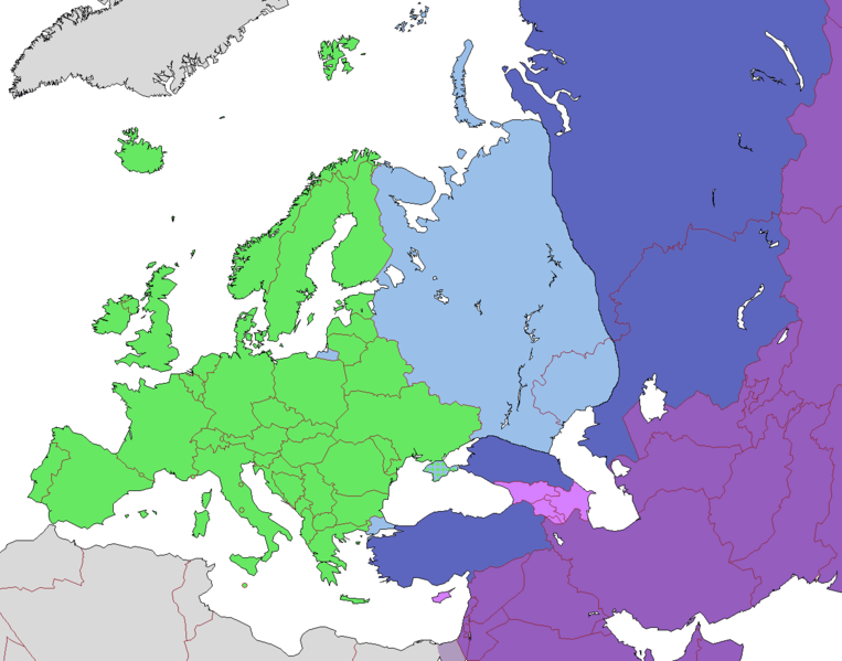
English: Map of Europe, indicating continental boundary (by Britannica and Great Soviet Encyclopedia) and transcontinental states.
States geographically in Europe (excepting overseas possessions)
Transcontinental states, European territory
Transcontinental states, Asian territory
Asian countries, sometimes referred to as Europe according to political, economic, and historical and cultural criteria (Azerbaijan, Armenia, Georgia, Cyprus)
Geographically Asian states (island states of Cyprus and Bahrain usually grouped with Asia geographically)
Asian part of Egypt Русский: Карта Европы с указанием границ частей света (по БСЭ и Британнике) и трансконтинентальных государств.
Государства, расположенные в Европе (за исключением заморских владений)
Трансконтинентальные государства, европейская территория
Трансконтинентальные государства, азиатская территория
Государства Азии, иногда относимые к Европе по политическим, экономическим, и историко-культурным критериям
Государства, расположенные в Азии
Азиатская часть Египта |
| تاريخ | |
| مصدر | |
| مؤلف |
.png)
الترخيص
الملف ده مترخص حسب رخصة المشاع الإبداعى نسبة المصنف للى مألفه - المشاركة بالمثل 3.0 العامه
- إنت حر:
- فى المشاركه – علشان نسخ و توزيع و بث العمل
- إنك تمزج – فى تكييف العمل
- بالشروط دى:
- نسبه ل – لازم يتنسب العمل للى مألفه بشكل مناسب و توفير رابط للرخصه وتحديد اذا حصلت تغييرات. ممكن ده يتعمل بأى طريقه معقوله، لكن مش بطريقه تشير ان مانح الرخصه بيوافقك على الاستعمال.
- مشاركه زي – لو عدت إنتاج المواد أو غيرت فيها، لازم تنشر مساهماتك اللى جايه من الأصل تحت ترخيص الأصل نفسه أو تحت ترخيص متوافق معاه.
| Annotations | This image is annotated: View the annotations at Commons |
تاريخ الفايل
اضغط على الساعه/التاريخ علشان تشوف الفايل زى ما كان فى الوقت ده.
| الساعه / التاريخ | صورة صغيرة | ابعاد | يوزر | تعليق | |
|---|---|---|---|---|---|
| دلوقتي | 10:23، 14 نوفمبر 2022 | | 1,268 × 996 (46 كيلوبايت) | Рагин1987 | Highlighted with a light purple hue the countries of Asia, sometimes attributed to Europe according to political, economic, and historical and cultural criteria (Transcaucasia, Cyprus). |
| 12:02، 29 اغسطس 2022 |  | 1,268 × 996 (46 كيلوبايت) | Рагин1987 | Small correction | |
| 07:03، 18 فبراير 2020 |  | 1,268 × 996 (56 كيلوبايت) | Insider | fix: mixed color. not dark blue | |
| 06:55، 18 فبراير 2020 |  | 1,268 × 996 (60 كيلوبايت) | Insider | Reverted to version as of 07:01, 13 October 2014 (UTC) Crimea that is Europe | |
| 09:04، 10 فبراير 2020 |  | 1,268 × 996 (84 كيلوبايت) | Compu wiki | Крым — это Россия. Crimea is Russia. | |
| 07:01، 13 اكتوبر 2014 |  | 1,268 × 996 (60 كيلوبايت) | Insider | Reverted to version as of 10:10, 1 July 2014 Crimea that is Europe | |
| 12:31، 11 اكتوبر 2014 |  | 1,268 × 996 (84 كيلوبايت) | Michael1238 | Crimea | |
| 10:10، 1 يوليه 2014 |  | 1,268 × 996 (60 كيلوبايت) | Insider | {{Information |Description={{en|1= Map of Europe, indicating continental boundary and transcontinental states. {{legend|#67e836|States geographically in Europe (excepting overseas possessions; island states UK, Ireland, Iceland and Malta usually group... |
استخدام الفايل
مافيش صفحات بتوصل للفايل ده.
استخدام الملف العام
الويكيات التانيه دى بتستخدم الفايل ده:
- الاستخدام ف hy.wikipedia.org
- الاستخدام ف kk.wikipedia.org
- الاستخدام ف ru.wikipedia.org