الفرق بين النسختين بتاع: «ماديرا»
تم حذف المحتوى تمت إضافة المحتوى
ص بوت: تزويد قوالب توماتيكى و/او تظبيط |
تبديل الكلام بـ '{{صندوق معلومات تجمع سكانى}} '''جزر ماديرا''' هيا ارخبيل ف المحيط الاطلنطى بتحكمها بورت...' وسم: استبدل |
||
| سطر 1: | سطر 1: | ||
{{صندوق معلومات تجمع سكانى}} |
|||
{{Geobox|Region |
|||
<!-- *** Heading *** --> |
|||
| name = ماديرا |
|||
| native_name = Madeira |
|||
| other_name = |
|||
| category = [[Autonomous area|Autonomous Region]] |
|||
| native_category = Região Autónoma |
|||
<!-- *** Names **** --> |
|||
| etymology = ''madeira'', [[Portuguese language|Portuguese]] for ''wood'' |
|||
| official_name = Região Autónoma da Madeira |
|||
| motto = {{lang|pt|Das ilhas, as mais belas e livres}}<br /><small>({{lang|en|''Of all islands, the most beautiful and free''}})</small> |
|||
| nickname = Pérola do Atlântico<br /><small>({{lang|en|''Pearl of the Atlantic''}})</small> |
|||
<!-- *** Image *** --> |
|||
| image = Funchal St. Clara Sé.JPG |
|||
| image_caption = A view of [[Funchal]], the capital city of the autonomous region. |
|||
| image_size = 235 |
|||
<!-- *** Symbols *** --> |
|||
| flag = Flag of Madeira.svg |
|||
| symbol = Coat of arms of Madeira.gif |
|||
<!-- *** Country *** --> |
|||
| country = {{flag|Portugal}} |
|||
| state_type = Autonomous Region |
|||
| state = {{flag|Madeira|name=Madeira}} |
|||
| region = Atlantic Ocean |
|||
| district = Tore-Madeira Ridge |
|||
| district_type = Subregion |
|||
| municipality = Madeira Platform,<br />Savage Islands submarine mount |
|||
| municipality_type = Position |
|||
<!-- *** Family *** --> |
|||
| border_type = Islands |
|||
| border_count = 4 |
|||
| border = Madeira |
|||
| border1 = [[Porto Santo Island|Porto Santo]] |
|||
| border2 = [[Desertas Islands|Desertas]] |
|||
| border3 = [[Savage Islands|Selvagens]] |
|||
| part_type = Municipalities |
|||
| part_count = 11 |
|||
| part = [[Calheta (Madeira)|Calheta]] |
|||
| part1 = Câmara de Lobos |
|||
| part2 = Funchal |
|||
| part3 = Machico |
|||
| part4 = Ponta do Sol |
|||
| part5 = Porto Moniz |
|||
| part6 = [[Vila Baleira|Porto Santo]] |
|||
| part7 = [[Ribeira Brava, Madeira|Ribeira Brava]] |
|||
| part8 = [[Santa Cruz, Madeira|Santa Cruz]] |
|||
| part9 = [[Santana, Madeira|Santana]] |
|||
| part10 = [[São Vicente, Madeira|São Vicente]] |
|||
| city_type = Capital |
|||
| city = Funchal |
|||
| landmark = |
|||
| river = |
|||
<!-- *** Locations *** --> |
|||
| capital_type = Largest city |
|||
| capital = Funchal |
|||
| capital_location = |
|||
| capital_region = Madeira |
|||
| capital_country = Madeira |
|||
| capital_elevation = |
|||
| capital_lat_d = 32 |
|||
| capital_lat_m = 39 |
|||
| capital_lat_s = 4 |
|||
| capital_lat_NS = N |
|||
| capital_long_d = 16 |
|||
| capital_long_m = 54 |
|||
| capital_long_s = 35 |
|||
| capital_long_EW = W |
|||
| highest = Pico Ruivo |
|||
| highest_location = Paul da Serra |
|||
| highest_region = [[Santana (Madeira)|Santana]] |
|||
| highest_country = Madeira |
|||
| highest_elevation = 1862 |
|||
| highest_lat_d = |
|||
| highest_lat_m = |
|||
| highest_lat_s = |
|||
| highest_lat_NS = N |
|||
| highest_long_d = |
|||
| highest_long_m = |
|||
| highest_long_s = |
|||
| highest_long_EW = W |
|||
| lowest = Sea level |
|||
| lowest_location = Atlantic Ocean |
|||
| lowest_region = |
|||
| lowest_country = Madeira |
|||
| lowest_elevation = 0 |
|||
| lowest_lat_d = |
|||
| lowest_lat_m = |
|||
| lowest_lat_s = |
|||
| lowest_lat_NS = |
|||
| lowest_long_d = |
|||
| lowest_long_m = |
|||
| lowest_long_s = |
|||
| lowest_long_EW = |
|||
<!-- *** Dimensions *** --> |
|||
| length = |
|||
| length_orientation = West-East |
|||
| width = |
|||
| width_orientation = North-South |
|||
| area = 801 |
|||
<!-- *** Population *** --> |
|||
| population = 267785 |
|||
| population_date = 2011 |
|||
| population_density = 308.5 |
|||
| population_note = Estimate<ref>http://www.ine.pt/scripts/flex_v10/Main.html</ref>{{increase}} |
|||
<!-- *** History & government *** --> |
|||
| established = c. 1420 |
|||
| established_type = Settlement |
|||
| established1 = c. 1895 |
|||
| established1_type = Administrative autonomy |
|||
| established2 = 4 September 1976 |
|||
| established2_type = Political autonomy |
|||
| date = c. 1415 |
|||
| date_type = Discovery |
|||
| government_location = Quinta Vigia |
|||
| government_region = [[Sé (Funchal)|Sé]] |
|||
| government_country = Funchal |
|||
| government_elevation = 51 |
|||
| government_lat_d = 32 |
|||
| government_lat_m = 38 |
|||
| government_lat_s = 42.39 |
|||
| government_lat_NS = N |
|||
| government_long_d = 16 |
|||
| government_long_m = 54 |
|||
| government_long_s = 57.16 |
|||
| government_long_EW = W |
|||
| management_location = Assembleia Regional |
|||
| management_region = [[Sé (Funchal)|Sé]] |
|||
| management_country = Funchal |
|||
| management_elevation = 16 |
|||
| management_lat_d = 32 |
|||
| management_lat_m = 38 |
|||
| management_lat_s = 49.96 |
|||
| management_lat_NS = N |
|||
| management_long_d = 16 |
|||
| management_long_m = 54 |
|||
| management_long_s = 29.59 |
|||
| management_long_EW = W |
|||
| leader = [[Alberto João Jardim]] |
|||
| leader_type = [[List of Presidents of the Regional Government of Madeira|President]] (Government) |
|||
| leader_party = [[Social Democratic Party (Portugal)|PPD-PSD]] |
|||
| leader1 = José Miguel Jardim d´Olival de Mendonça |
|||
| leader1_type = President (Assembleia) |
|||
| leader1_party = [[Social Democratic Party (Portugal)|PPD-PSD]] |
|||
<!-- *** Codes *** --> |
|||
| timezone = [[Western European Time|WET]] |
|||
| utc_offset = +0 |
|||
| timezone_DST = [[Western European Summer Time|WEST]] |
|||
| utc_offset_DST = +1 |
|||
| postal_code = 9XXX-XXX |
|||
| area_code = (+351) 291 XXX XXX |
|||
| iso_code = PT |
|||
| iso_subcode = 30 |
|||
| code = [[.pt]] |
|||
| code_type = [[country code top-level domain|ccTLD]] |
|||
| code1 = dd-mm-yyyy |
|||
| code1_type = Date format |
|||
| code2 = right-side |
|||
| code2_type = Drive |
|||
<!-- *** Free fields *** --> |
|||
| free_type = [[Demonym]] |
|||
| free = Madeiran; Madeirense |
|||
| free1_type = [[Patron Saint]] |
|||
| free1 = [[Blessed Virgin Mary|Nossa Senhora do Monte]] |
|||
| free2_type = Holiday |
|||
| free2 = 1 July |
|||
| free3_type = Anthem |
|||
| free3 = {{lang|pt|''[[A Portuguesa]]''}} (national)<br /> {{lang|pt|''[[Hino da Região Autónoma da Madeira|Hino da Madeira]]''}} (regional) |
|||
| free4 = [[Euro]] (€)<ref>Until 2002, the [[Portuguese escudo]] was used in financial transactions, and until 1910 the [[Portuguese real]] was the currency used by the monarchy of Portugal.</ref> |
|||
| free4_type = Currency |
|||
| free5 = € 6,361 billion<ref name="GDP per inhabitant in 2008">{{cite web|title= GDP per inhabitant in 2008| publisher= Eurostat|url=http://epp.eurostat.ec.europa.eu/cache/ITY_PUBLIC/1-24022011-AP/EN/1-24022011-AP-EN.PDF|accessdate=29 March 2011}}</ref> {{increase}} (''2008'') |
|||
| free5_type = [[Gross domestic product]] ([[Purchasing power parity|PPP]]) |
|||
| free6 = € 25,800-$35,589<ref name="GDP per inhabitant in 2008"/> {{increase}} |
|||
| free6_type = Per capita GDP |
|||
<!-- *** Maps *** --> |
|||
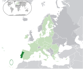
| map = EU-Portugal with Madeira circled.svg |
|||
| map1 = Madeira topographic map-fr.svg |
|||
| map_caption = Location of Madeira relative to Portugal (green) and the rest of the [[European Union]] (light green) |
|||
| map1_caption = Distribution of the islands of the archipelago (not including the [[Savage islands]]) |
|||
| map_background = |
|||
| map_locator = |
|||
| map_locator_x = |
|||
| map_locator_y = |
|||
<!-- *** Website *** --> |
|||
| commons = Madeira |
|||
| statistics = [[Instituto Nacional de Estatística]]<ref name="INE">{{citation|url=http://www.ine.pt/xportal/xmain?xpid=INE&xpgid=ine_publicacoes&PUBLICACOESpub_boui=122114780&PUBLICACOESmodo=2|title=Censos 2011 - Resultadas Preliminares|trans_title=2011 Census - Preliminary Results|publisher=Instituto Nacional de Estatística|language=Português|location=Lisbon, Portugal|language=Portuguese|accessdate=1 July 2011|year=2010|editor=INE|editor-link=Instituto Nacional de Estatística}}</ref> |
|||
| website = [http://www.gov-madeira.pt www.gov-madeira.pt] |
|||
<!-- *** Footnotes *** --> |
|||
| footnotes = Geographic detail from CAOP (2010)<ref>{{citation|url=http://www.igeo.pt/produtos/cadastro/caop/download/Areas_Freg_Mun_Dist_CAOP2010.zip|title=Carta Administrativa Oficial de Portugal|publisher=Instituto Geográfico Português|location=Lisbon, Portugal|language=Portuguese|accessdate=1 July 2011|year=2010|editor=IGP}}</ref> produced by Instituto Geográfico Português (IGP) |
|||
}} |
|||
'''جزر ماديرا''' هيا [[ارخبيل]] ف [[المحيط الاطلنطى]] بتحكمها [[بورتوجال]] و عاصمتها [[فونتشال]] |
'''جزر ماديرا''' هيا [[ارخبيل]] ف [[المحيط الاطلنطى]] بتحكمها [[بورتوجال]] و عاصمتها [[فونتشال]] |
||
تعديلات من 08:16، 12 اغسطس 2020
| ||||
|---|---|---|---|---|
 | ||||
 |
 |
|||
 | ||||
| الشعار الوطنى (بالپورتوجالى: Das Ilhas as Mais Belas e Livres) | ||||
| النشيد: | ||||
| البلد | ||||
| التقسيم الادارى | پورتوجال | |||
| الارض و السكان | ||||
| احداثيات | 32°45′N 17°00′W / 32.75°N 17°W [1] | |||
| القاره | افريقيا | |||
| مسطحات مائيه قريبه | المحيط الاطلنطى | |||
| اعلى قمه | جبل پيكو رويڤو | |||
| المساحه | ||||
| التعداد السكانى | ||||
| الحكم | ||||
| التأسيس والسيادة | ||||
| تاريخ التأسيس | 1976 | |||
| بيانات تانيه | ||||
| رمز الاتصال الهاتفى المحلى | 351 291 | |||
| أرقام التعريف البحريه | 255 | |||
| الموقع الرسمى | الموقع الرسمى | |||
| [[تصنيف: غلط فى قوالب ويكى بيانات|]] | ||||

| ||||
| تعديل مصدري - تعديل | ||||
جزر ماديرا هيا ارخبيل ف المحيط الاطلنطى بتحكمها بورتوجال و عاصمتها فونتشال


