
ملف:Saint Helena Island.jpg

الصوره الاصليه (1,440 × 1,080 بكسل حجم الفايل: 634 كيلوبايت، نوع MIME: image/jpeg)
الخلاصة

|
قُيِّمت هذه الصورة وفقاً لمعايير تقييم الصُّور، ونتيجةً لذلك، فإنها تعدُّ صورةً ذات قيمةٍ عاليةٍ في كُومِنز في نطاق: Saint Helena Island. يُمكن أيضاً مُراجعة صفحة ترشيح الصُّورة للتقييم. |
| وصف |
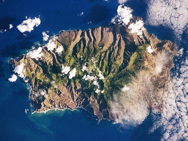
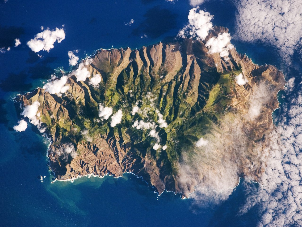
English: This astronaut photograph shows the island’s sharp peaks and deep ravines; the rugged topography results from erosion of the volcanic rocks that make up the island. The change in elevation from the coast to the interior creates a climate gradient. The higher, wetter centre is covered with green vegetation, whereas the lower coastal areas are drier and hotter, with little vegetation cover.
Français : Photo de l'île de Sainte Hélène prise par un astronaute de la NASA. On peut voir les pics élevés de l'île et ses ravines profondes. Cette topographie accidentée résulte de l'action de l'érosion sur les roches volcaniques dont l'île est constituée. Le changement d'élévation entre la périphérie et le centre de l'île créé un gradient climatique: le sommet est plus frais et humide, il est couvert de végétation. Les côtes, plus chaudes et sèches, laissent apparaitre la roche nue.
|
||||||||||||||||||||||||||||||||||||||||||||||||||||||
| تاريخ | |||||||||||||||||||||||||||||||||||||||||||||||||||||||
| مصدر | NASA Earth Observatory | ||||||||||||||||||||||||||||||||||||||||||||||||||||||
| مؤلف | This image was taken by the NASA Expedition 19 crew. | ||||||||||||||||||||||||||||||||||||||||||||||||||||||
| إصدارات أخرى |
|
||||||||||||||||||||||||||||||||||||||||||||||||||||||

| موقع الكاميرا | | هذه وغيرها من الصور في مواقعها على: خريطة الشارع المفتوحة |
|---|
This photograph was acquired with a Nikon 2DXs digital camera fitted with a 400 mm lens, and is provided by the ISS Crew Earth Observations experiment and Image Science & Analysis Laboratory, Johnson Space Centre.
Deutsch: Dieses Bild wurde als Bild der Woche auf der tschechischen Wikipedia für die 5 Woche ausgewählt, 2016. English: This image was selected as a picture of the week on the Czech Wikipedia for 5th week, 2016. Français : Cette image est sélectionnée en tant qu’image de la semaine sur la Wikipédia Tchèque pour la 5e semaine de 2016. Italiano: Questa immagine è stata selezionata come Immagine della settimana su Wikipedia in ceco per la V settimana del 2016. Македонски: Сликава е избрана за слика на неделата на чешката Википедија за V недела од 2016 година. Русский: Эта иллюстрация была выбрана изображением недели в чешском разделе «Википедии» для недели номер 5 2016 года. Українська: Ця ілюстрація була вибрана зображенням тижня в чеському розділі «Вікіпедії» для тижня номер 5, 2016 року. |
الترخيص
| يقع هذا العمل في النِّطاق العامّ في الولايات المُتحدة الأمريكيَّة لأَنَّه عملٌ خالِصٌ من إِنتاج وكالة الفضاء الأمريكيَّة. تنصُ حقوق التَّأليف والنَّشر الخاصَّة بوكالة الفضاء الأمريكيَّة على أنَّ "أعمال الوكالة غير مَحميَّة بحقوق التَّأليف والنَّشر ما لم يُذكر خلافُ ذلك". لمزيدٍ من المعلومات انظر القالِب {{PD-USGov}} وصفحة حقوق التَّأليف والنَّشر الخاصَّة بالوكالة وصفحة سياسة الصُّور الخاصَّة بمُختبر الدَّفع النَّفَّاث. | ||
 |
تنبيهات:
|
| Annotations | This image is annotated: View the annotations at Commons |
تاريخ الفايل
اضغط على الساعه/التاريخ علشان تشوف الفايل زى ما كان فى الوقت ده.
| الساعه / التاريخ | صورة صغيرة | ابعاد | يوزر | تعليق | |
|---|---|---|---|---|---|
| دلوقتي | 11:28، 23 مارس 2015 | | 1,440 × 1,080 (634 كيلوبايت) | Julian Herzog | Reverted to version as of 18:00, 19 March 2015, rotation was done then. |
| 08:00، 20 مارس 2015 |  | 1,440 × 1,080 (634 كيلوبايت) | SteinsplitterBot | Bot: Image rotated by 180° | |
| 18:00، 19 مارس 2015 |  | 1,440 × 1,080 (634 كيلوبايت) | SteinsplitterBot | Bot: Image rotated by 180° | |
| 09:40، 15 يونيه 2009 |  | 1,440 × 1,080 (622 كيلوبايت) | Originalwana | {{Information |Description={{en|1=This astronaut photograph shows the island’s sharp peaks and deep ravines; the rugged topography results from erosion of the volcanic rocks that make up the island. The change in elevation from the coast to the interior |
استخدام الفايل
ال1 صفحة دى فيها وصله للفايل ده:
استخدام الملف العام
الويكيات التانيه دى بتستخدم الفايل ده:
- الاستخدام ف als.wikipedia.org
- الاستخدام ف ar.wikipedia.org
- الاستخدام ف ast.wikipedia.org
- الاستخدام ف az.wikipedia.org
- الاستخدام ف be.wikipedia.org
- الاستخدام ف bg.wikipedia.org
- الاستخدام ف br.wikipedia.org
- الاستخدام ف bs.wikipedia.org
- الاستخدام ف ca.wikipedia.org
- الاستخدام ف ceb.wikipedia.org
- الاستخدام ف ce.wikipedia.org
- الاستخدام ف co.wikipedia.org
- الاستخدام ف cs.wikipedia.org
- الاستخدام ف da.wikipedia.org
- الاستخدام ف de.wikipedia.org
- الاستخدام ف en.wikipedia.org
- الاستخدام ف en.wikiversity.org
- الاستخدام ف eo.wikipedia.org
- الاستخدام ف es.wikipedia.org
- الاستخدام ف es.wiktionary.org
- الاستخدام ف fi.wiktionary.org
- الاستخدام ف frp.wikipedia.org
- الاستخدام ف fr.wikipedia.org
- الاستخدام ف fr.wikivoyage.org
- الاستخدام ف ga.wikipedia.org
- الاستخدام ف gl.wikipedia.org
- الاستخدام ف he.wikipedia.org
- الاستخدام ف hy.wikipedia.org
- الاستخدام ف ig.wikipedia.org
- الاستخدام ف it.wikipedia.org
- الاستخدام ف it.wikivoyage.org
اعرض استخدام عام اكتر للملف ده.