
ملف:Qattara depression map.png
Qattara_depression_map.png (599 × 435 بكسل حجم الفايل: 54 كيلوبايت، نوع MIME: image/png)

|
هذه locator map الصورة / الصورتان باستعمال رسومات متجهية ملفات رسوميات شعاعية.
It is recommended to name the SVG file "Qattara depression map.svg" - then the template Vector version available (or Vva) does not need the new image name parameter.
|
| وصف | |
| تاريخ | 20 مايو 2005 (تاريخ الرفع الأصيل) |
| مصدر | Adapted from https://www.un.org/geospatial/content/egypt and en:Image:Eg-map.png |
| مؤلف | الرَّافِع الأصيل للملفِّ هو ChrisO في ويكيبيديا الإنجليزية. |
الترخيص
| This image is a map derived from a United Nations map.
Unless stated otherwise, UN maps are to be considered in the public domain. This applies worldwide. UN maps are, in principle, open source material and you can use them in your work or for making your own map. UN requests however that you delete the UN name, logo and reference number upon any modification to the map. Content of your map will be your responsibility. You can state in your publication, if you wish, something like: based on UN map … (map name, map number, revision number and date). See: Geospatial Information Section. And: Geospatial, location data for a better world. |
 |
سجلُّ الرَّفع الأصيل
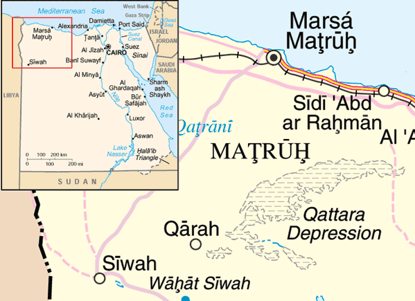
- 2005-05-20 22:10 ChrisO 599×435× (54888 bytes) Map of the [[Qattara Depression]], [[Egypt]] Adapted from http://www.un.org/Depts/Cartographic/map/profile/egypt.pdf and [[:Image:Eg-map.png]] {{UN map}}
تاريخ الفايل
اضغط على الساعه/التاريخ علشان تشوف الفايل زى ما كان فى الوقت ده.
| الساعه / التاريخ | صورة صغيرة | ابعاد | يوزر | تعليق | |
|---|---|---|---|---|---|
| دلوقتي | 12:29، 31 مارس 2009 | | 599 × 435 (54 كيلوبايت) | File Upload Bot (Magnus Manske) | {{BotMoveToCommons|en.wikipedia|year={{subst:CURRENTYEAR}}|month={{subst:CURRENTMONTHNAME}}|day={{subst:CURRENTDAY}}}} {{Information |Description={{en|Map of the en:Qattara Depression, en:Egypt Adapted from http://www.un.org/Depts/Cartographic |
استخدام الفايل
ال1 صفحة دى فيها وصله للفايل ده:
استخدام الملف العام
الويكيات التانيه دى بتستخدم الفايل ده:
- الاستخدام ف ar.wikipedia.org
- الاستخدام ف cs.wikipedia.org
- الاستخدام ف da.wikipedia.org
- الاستخدام ف en.wikipedia.org
- الاستخدام ف eo.wikipedia.org
- الاستخدام ف es.wikipedia.org
- الاستخدام ف fa.wikipedia.org
- الاستخدام ف fi.wikipedia.org
- الاستخدام ف fr.wikipedia.org
- الاستخدام ف ga.wikipedia.org
- الاستخدام ف hr.wikipedia.org
- الاستخدام ف id.wikipedia.org
- الاستخدام ف ml.wikipedia.org
- الاستخدام ف my.wikipedia.org
- الاستخدام ف no.wikipedia.org
- الاستخدام ف uk.wikipedia.org
- الاستخدام ف ur.wikipedia.org
- الاستخدام ف vi.wikipedia.org
- الاستخدام ف war.wikipedia.org
- الاستخدام ف zh.wikipedia.org
- الاستخدام ف zu.wikipedia.org