
ملف:Omulyakhskaya and Khromskaya Bays, Northern Siberia.jpg

حجم البروفه دى: 800 × 533 بكسل. الأبعاد التانيه: 320 × 213 بكسل | 640 × 427 بكسل | 1,024 × 683 بكسل | 1,280 × 853 بكسل | 2,560 × 1,707 بكسل | 4,696 × 3,131 بكسل.
الصوره الاصليه (4,696 × 3,131 بكسل حجم الفايل: 4.69 ميجابايت، نوع MIME: image/jpeg)
الخلاصة
| وصف |
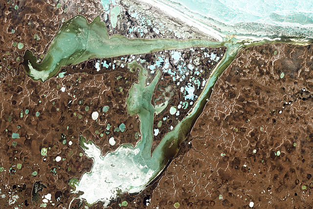
English: Natural-colour image of the Omulyakhskaya and Khromskaya Bays, Russia. The land around the bays is dotted with thermokarst lakes, which result from water released by thawing permafrost. The water in a thermokarst lake doesn’t always stay put; these lakes can melt through the surrounding permafrost and drain into a nearby water body, especially if it sits at a slightly lower elevation. This appears to have occurred in multiple lakes between the bays shown above. (The compound lakes are identifiable by their uneven margins.) Coastal erosion and river migration also can deplete the lakes. Dark brown spots, especially numerous east of Khromskaya Bay, are probably locations of former thermokarst lakes.
Image captured by the Thematic Mapper on the Landsat 5 satellite. Landsat data provided by the United States Geological Survey. Français : Image en couleurs naturelles des baies d’Omulyakhskaya et de Khromskaya (Russie). On distingue autour de ces baies une constellation de lacs thermokarstiques, résultant de l'eau libérée par le dégel du pergélisol. L’eau d’un lac thermokarst peut brutalement disparaitre à travers le pergélisol environnant et se déverser dans un plan d'eau voisin, surtout s'il se trouve à une altitude légèrement inférieure. Cela semble s'être produit dans plusieurs de slacs situés sur cette image (Les lacs composés sont identifiables par leurs marges inégales.) L'érosion côtière et la migration des rivières peuvent aussi vider des lacs. Les taches brun foncé, particulièrement nombreuses à l'est de la baie de Khromskaya, sont probablement des emplacements d'anciens lacs thermokarstiques. Image capturée par le Thematic Mapper sur le satellite Landsat 5. Données Landsat fournies par le United States Geological Survey. |
| تاريخ | |
| مصدر | NASA Earth Observatory |
| مؤلف | Jesse Allen and Robert Simmon |
| إصدارات أخرى |
الترخيص
| يقع هذا العمل في النِّطاق العامّ في الولايات المُتحدة الأمريكيَّة لأَنَّه عملٌ خالِصٌ من إِنتاج وكالة الفضاء الأمريكيَّة. تنصُ حقوق التَّأليف والنَّشر الخاصَّة بوكالة الفضاء الأمريكيَّة على أنَّ "أعمال الوكالة غير مَحميَّة بحقوق التَّأليف والنَّشر ما لم يُذكر خلافُ ذلك". لمزيدٍ من المعلومات انظر القالِب {{PD-USGov}} وصفحة حقوق التَّأليف والنَّشر الخاصَّة بالوكالة وصفحة سياسة الصُّور الخاصَّة بمُختبر الدَّفع النَّفَّاث. | ||
 |
تنبيهات:
|
| الشروح | هذه الصورة مشروحة: أظهر الشروح في كومنز |
تاريخ الفايل
اضغط على الساعه/التاريخ علشان تشوف الفايل زى ما كان فى الوقت ده.
| الساعه / التاريخ | صورة صغيرة | ابعاد | يوزر | تعليق | |
|---|---|---|---|---|---|
| دلوقتي | 13:39، 14 اغسطس 2011 | | 4,696 × 3,131 (4.69 ميجابايت) | Originalwana | {{Information |Description ={{en|1=Natural-colour image of the Omulyakhskaya and Khromskaya Bays. The land around the bays is dotted with thermokarst lakes, which result from water released by thawing permafrost. The water |
استخدام الفايل
ال1 صفحة دى فيها وصله للفايل ده:
استخدام الملف العام
الويكيات التانيه دى بتستخدم الفايل ده:
- الاستخدام ف be.wikipedia.org
- الاستخدام ف bg.wikipedia.org
- الاستخدام ف ceb.wikipedia.org
- الاستخدام ف cs.wikipedia.org
- الاستخدام ف de.wikipedia.org
- الاستخدام ف en.wikipedia.org
- الاستخدام ف es.wikipedia.org
- الاستخدام ف fa.wikipedia.org
- الاستخدام ف it.wikipedia.org
- الاستخدام ف pl.wikipedia.org
- الاستخدام ف tr.wikipedia.org
- الاستخدام ف uk.wikipedia.org
- الاستخدام ف www.wikidata.org