
ملف:Moyen Orient 13e siècle.png
حجم البروفه دى: 800 × 575 بكسل. الأبعاد التانيه: 320 × 230 بكسل | 640 × 460 بكسل | 1,024 × 736 بكسل | 1,280 × 919 بكسل | 1,885 × 1,354 بكسل.
الصوره الاصليه (1,885 × 1,354 بكسل حجم الفايل: 2.87 ميجابايت، نوع MIME: image/png)
| وصف |
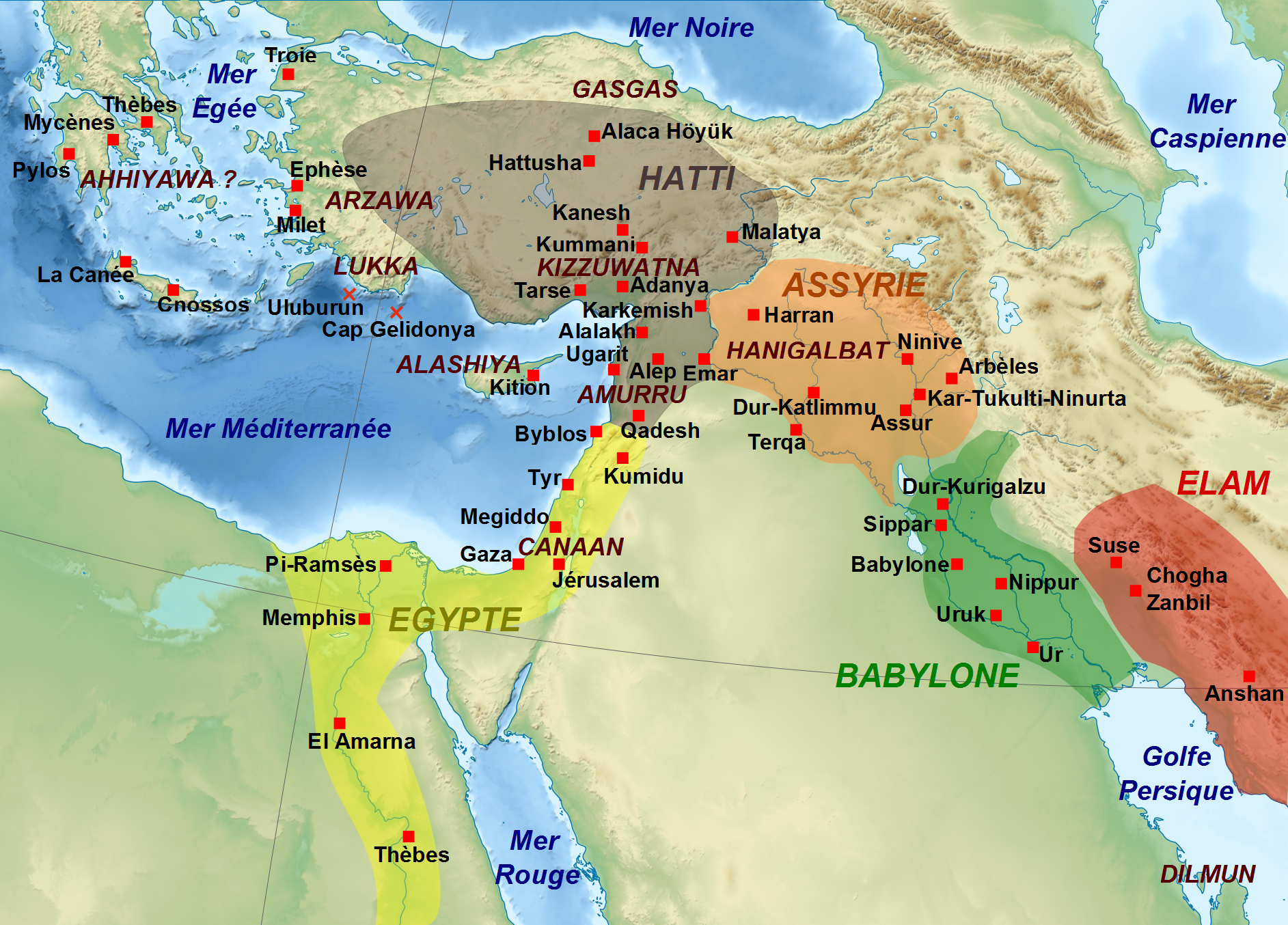
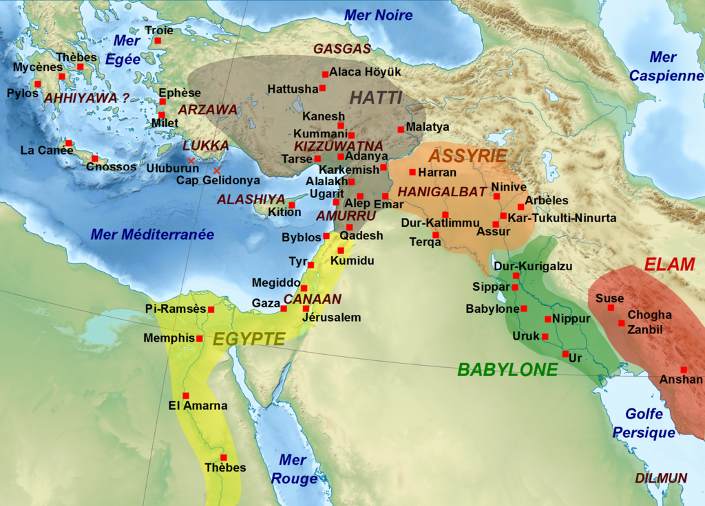
English: Map showing the approximate extension of the main kingdoms of the Middle East durint the 13th century BC, with the main cities and archaeological sites, and some regions. Français : Carte montrant l'extension approximative des principaux royaumes du Moyen-Orient au XIIIe siècle av. J.-C., avec la localisation des villes et sites archéologiques principaux, ainsi que de certaines régions. |
| تاريخ | (UTC) |
| مصدر | |
| مؤلف |
|
| إصدارات أخرى |
[]
|


| هذا رسمٌ مُعَدَّلٌ رقميَّاً من النسخة الأصليَّة. التعديلات هي: Conversion en png.. يُمكن الاطلاع على النسخة الأصليَّة هنا: Moyen Orient 13e siècle.svg:
|
أنا، صاحب حقوق التأليف والنشر لهذا العمل، أنشر هذا العمل تحت الرخص التالية:
- إنت حر:
- فى المشاركه – علشان نسخ و توزيع و بث العمل
- إنك تمزج – فى تكييف العمل
- بالشروط دى:
- نسبه ل – لازم يتنسب العمل للى مألفه بشكل مناسب و توفير رابط للرخصه وتحديد اذا حصلت تغييرات. ممكن ده يتعمل بأى طريقه معقوله، لكن مش بطريقه تشير ان مانح الرخصه بيوافقك على الاستعمال.
- مشاركه زي – لو عدت إنتاج المواد أو غيرت فيها، لازم تنشر مساهماتك اللى جايه من الأصل تحت ترخيص الأصل نفسه أو تحت ترخيص متوافق معاه.

|
يسمح بنسخ و توزيع و / أو تعديل الوثيقه دى تحت شروط رخصة جنو للوثائق الحره، الإصدار 1.2 أو أى إصدار تنشره مؤسسة البرمجيات الحره؛ بدون أقسام ثابته و بدون نصوص أغلفه أماميه و بدون نصوص أغلفه خلفيه. نسخه من الرخصه متضمنه ف قسم اسمه GNU Free Documentation License. |
اختار الرخصه اللى تناسبك.
سجلُّ الرَّفع الأصيل
This image is a derivative work of the following images:
- File:Moyen_Orient_13e_siècle.svg licensed with Cc-by-sa-3.0,2.5,2.0,1.0, GFDL
- 2010-11-14T11:01:14Z Zunkir 1885x1354 (4161368 Bytes) {{Information |Description={{Multilingual description |fr= Carte montrant l'extension approximative des principaux royaumes du Moyen-Orient au XIIIe siècle av. J.-C., avec la localisation des villes et sites archéologiques
Uploaded with derivativeFX
تاريخ الفايل
اضغط على الساعه/التاريخ علشان تشوف الفايل زى ما كان فى الوقت ده.
| الساعه / التاريخ | صورة صغيرة | ابعاد | يوزر | تعليق | |
|---|---|---|---|---|---|
| دلوقتي | 10:15، 14 يوليه 2011 | | 1,885 × 1,354 (2.87 ميجابايت) | Zunkir | Ajout du pays de Lukka. |
| 11:06، 14 نوفمبر 2010 |  | 1,885 × 1,354 (2.87 ميجابايت) | Zunkir | {{Information |Description={{Multilingual description |fr= Carte montrant l'extension approximative des principaux royaumes du Moyen-Orient au XIIIe siècle av. J.-C., avec la localisation des villes et sites archéologiques principaux, ainsi que de certa |
استخدام الفايل
ال1 صفحة دى فيها وصله للفايل ده:
استخدام الملف العام
الويكيات التانيه دى بتستخدم الفايل ده:
- الاستخدام ف ar.wikipedia.org
- الاستخدام ف es.wikipedia.org
- الاستخدام ف fr.wikipedia.org
- الاستخدام ف it.wikipedia.org
- الاستخدام ف pl.wikipedia.org