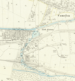
ملف:Map of the Flight of locks at Falkirk.png

محتويات الصفحة غير مدعومة بلغات أخرى.
من ويكيبيديا، الموسوعه الحره

الصوره الاصليه(836 × 908 بكسل حجم الفايل: 896 كيلوبايت، نوع MIME: image/png)

الملف دا من ويكيميديا كومنز و ممكن تستعمله المشاريع التانيه. الوصف بتاعه صفحة وصف الملف هناك معروض تحت..

الخلاصة

وصف
English: Part of OS sheet XXX.2 showing the flight of canal locks at Falkirk and a section of the Antonine Wall between Rough Castle and Camelon at a scale of 1:2,500 or about 25 inches to one mile. Second Edition, 1897
تاريخ
مصدر
This image is available from the National Library of Scotland
https://maps.nls.uk/geo/explore/side-by-side/#zoom=16&lat=55.99833&lon=-3.81570&layers=168&right=BingHyb
مؤلف Director General of the Ordnance Survey, UK

الترخيص

This work is an Ordnance Survey map over 50 years old, which is covered by Crown Copyright which in this case expires 50 years after publication. Ordnance Survey does however ask that they be credited and that the date of publication be given. Any ancillary rights gained through the creation of the electronic version are granted as freely usable under any circumstances.
Public domain
هذا العمل مِن إِنتاج حكومة المملكة المُتحدة وهو في النطاق العام لأن أَحد البنود التالية يَنطبق عليه:
  • صورة ضوئِية التقطت قبل 1 يونيو 1957م.
  • عمل منشور قبل 1974
  • عمل فني مغاير للنقش أَو التصوير الضَّوئِيّ (مثلاً: رسم) أُنشِئ قبل 1974.

صرَّح مكتب معلومات القطاع العام (HMSO) بأَن نفاد حقوق التأليف والنشر لأعمال التاج البريطاني تسري على المستوى العالمي. (التصريحمزيد من المعلومات.

انظر أيضاً حقوق التأليف والنشر وتفاصيل حقوق التأليف والنشر لأَعمال التاج البريطاني.

Deutsch  English  Español  français  italiano  Nederlands  polski  português  sicilianu  slovenščina  suomi  Türkçe  македонски  русский  українська  മലയാളം  한국어  日本語  简体中文  繁體中文  العربية  +/−

الشروحات

أضف شرحاً من سطر واحد لما يُمثِّله هذا الملف

العناصر المصورة في هذا الملف

يُصوِّر العربية

31 ديسمبر 1897جريجوري

نوع الوسائط العربية

image/png

تاريخ الفايل

اضغط على الساعه/التاريخ علشان تشوف الفايل زى ما كان فى الوقت ده.

الساعه / التاريخصورة صغيرةابعاديوزرتعليق
دلوقتي22:28، 30 مايو 2020تصغير للنسخة بتاريخ 22:28، 30 مايو 2020836 × 908 (896 كيلوبايت)Knipptang=={{int:filedesc}}== {{Information |description={{en|1=Part of OS sheet XXX.2 showing the flight of canal locks at Falkirk and a section of the Antonine Wall between Rough Castle and Camelon at a scale of 1:2,500 or about 25 inches to one mile. Second Edition, 1897}} |date=1897-12-31 |source={{NLS Collections}} https://maps.nls.uk/geo/explore/side-by-side/#zoom=16&lat=55.99833&lon=-3.81570&layers=168&right=BingHyb |author=Director General of the Ordnance Survey, UK |permission= |other version...

ال1 صفحة دى فيها وصله للفايل ده:

استخدام الملف العام

الويكيات التانيه دى بتستخدم الفايل ده: