
ملف:Kanawha Ohio confluence.jpg

حجم البروفه دى: 751 × 600 بكسل. الأبعاد التانيه: 301 × 240 بكسل | 601 × 480 بكسل | 962 × 768 بكسل | 1,280 × 1,022 بكسل | 1,500 × 1,198 بكسل.
الصوره الاصليه (1,500 × 1,198 بكسل حجم الفايل: 724 كيلوبايت، نوع MIME: image/jpeg)
الخلاصة
| وصف |
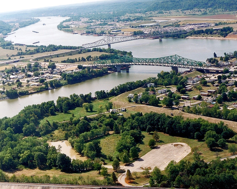
English: The confluence of the Kanawha and Ohio Rivers. The Kanawha River flows in from the left of the picture and joins the Ohio, meandering off in the distance. The town of Point Pleasant, West Virginia is in the foreground on the right. Henderson, West Virginia is on the left. The Ohio River forms the boundary between West Virginia and Ohio. The town of Gallipolis, Ohio lies in the far distance across the Ohio River. The view is to the west-southwest down the river. |
|||
| تاريخ | قبل 2007 | |||
| مصدر |
U.S. Army Corps of Engineers Digital Visual Library Image page Image description page Digital Visual Library home page |
|||
| مؤلف | Charles Johnson, U.S. Army Corps of Engineers | |||
| سماح (إعادة استخدام الملف ده) |
|
|||
| الموقع | Point Pleasant, West Virginia, USA |
| موقع الكاميرا | | هذه وغيرها من الصور في مواقعها على: خريطة الشارع المفتوحة |
|---|
| Annotations | This image is annotated: View the annotations at Commons |
تاريخ الفايل
اضغط على الساعه/التاريخ علشان تشوف الفايل زى ما كان فى الوقت ده.
| الساعه / التاريخ | صورة صغيرة | ابعاد | يوزر | تعليق | |
|---|---|---|---|---|---|
| دلوقتي | 04:52، 23 مارس 2007 | | 1,500 × 1,198 (724 كيلوبايت) | DanMS | {{Information | Description = {{en|The confluence of the Kanawha and Ohio Rivers. The Kanawha River flows in from the left of the picture and joins the Ohio, meandering off in the distance. The town of Point Pleasant, West Virginia is in the foreground |
استخدام الفايل
ال2 صفحة دى فيها وصله للفايل ده:
استخدام الملف العام
الويكيات التانيه دى بتستخدم الفايل ده:
- الاستخدام ف ar.wikipedia.org
- الاستخدام ف ca.wikipedia.org
- الاستخدام ف ceb.wikipedia.org
- الاستخدام ف ce.wikipedia.org
- الاستخدام ف cy.wikipedia.org
- الاستخدام ف dag.wikipedia.org
- الاستخدام ف de.wikipedia.org
- الاستخدام ف en.wikipedia.org
- الاستخدام ف en.wikivoyage.org
- الاستخدام ف es.wikipedia.org
- الاستخدام ف eu.wikipedia.org
- الاستخدام ف fa.wikipedia.org
- الاستخدام ف fr.wikipedia.org
- الاستخدام ف hu.wikipedia.org
- الاستخدام ف it.wikipedia.org
- الاستخدام ف ja.wikipedia.org
- الاستخدام ف ko.wikipedia.org
- الاستخدام ف kw.wikipedia.org
- الاستخدام ف lld.wikipedia.org
- الاستخدام ف no.wikipedia.org
- الاستخدام ف pl.wikipedia.org
- الاستخدام ف pt.wikipedia.org
- الاستخدام ف ro.wikipedia.org
- الاستخدام ف ru.wikipedia.org
- الاستخدام ف sh.wikipedia.org
- الاستخدام ف simple.wikipedia.org
- الاستخدام ف sr.wikipedia.org
- الاستخدام ف tt.wikipedia.org
اعرض استخدام عام اكتر للملف ده.