
ملف:India Tamil Nadu locator map.svg

الصوره الاصليه (ملف SVG، اساسا 1,574 × 1,738 بكسل، حجم الملف: 836 كيلوبايت)
| العنوان |
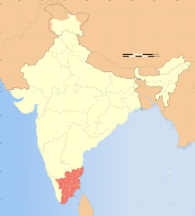
Tamil Nadu locator map |
|||||||||
| الوصف |
I am Kavita Dangi I study in 8th class and I have shared this map with you guys to get some knowledge if you don't know where is Tamilnadu then here it in the map thank you then please give a review |
|||||||||
| Map legend |
 |
|||||||||
| تاريخ | Pagal | |||||||||
| مصدر |
عمل شخصى |
|||||||||
| الصانع |
|
|||||||||
| سماح (إعادة استخدام الملف ده) |
أنا، صاحب حقوق التأليف والنشر لهذا العمل، أنشر هذا العمل تحت الرخصة التالية: الملف ده مترخص حسب رخصة المشاع الإبداعى نسبة المصنف للى مألفه - المشاركة بالمثل 3.0 العامه
|
|||||||||
| Geotemporal data | ||||||||||
| تاريخ التمثيل | النصف الثاني من القرن 20 و القرن 21 | |||||||||
| نظام المراجع المكاني | conic | |||||||||
| Bounding box |
|
|||||||||
| Georeferencing | If inappropriate please set warp_status = skip to hide. | |||||||||
| Archival data | ||||||||||
| ملاحظات | Part of WikiProject India Maps | |||||||||
| إصدارات أخرى |
|
|||||||||
| SVG منشأ الملف | هذا الرسم المتجهي أُنشئ بواسطة Adobe Illustrator |
|||||||||


Notes
Depiction of India's borders
- The territorial boundaries of India are shown as per the actual ground situation in accordance with international practices followed by the United Nations ([1], [2]) and the National Geographic Society ([3], [4])
- This map is meant to be for illustrative purpose only and is not authenticated by official government sources. Please check the list of sources and references used to create the map for a measure of accuracy and verifiability.
- The usage of these maps in India, Pakistan and China are governed by different laws that restrict depictions of boundaries other than what is officially recognized by the state. Please check local laws and modify the map accordingly before use.
Explanation of disputed boundaries


- Boundary of Indian claim : The territory India claims is legally theirs, but the claim is disputed by China and Pakistan.
- Line of Control/Line of Conflict : The de facto administrative boundary recognised by the international community. This UN ceasefire line is considered as a temporary solution to an ongoing conflict since the departure of the British Raj.
Borders of disputed regions
The depicted extent of the former territory of the British Indian Empire, succeeded by Republic of India, may not be accepted by few countries as legal due to ongoing border disputes:
- The northern Himalayan region of the disputed territory Indian-administered Kashmir is claimed by India including (Pakistan-administered Kashmir) and the Chinese-occupied territory of (Ladakh plateau). Since 1972, it is divided between all three countries. See also Line of Control and Line of Actual Control.
- Siachen glacier (shown white) is an actively contested region between India and Pakistan. Since 1984, the region is under Indian control.
- The northeastern territory of Arunachal Pradesh is almost entirely claimed by China as part of its Tibetan territory.
- Minor areas of eastern Kashmir's Ladakh division, Himachal Pradesh and Uttarakhand on the Chinese frontier are claimed by China. These areas are under Indian control.
- A small area of Uttarakhand adjoining the Nepal border along the Sarda river is disputed between the two countries.
For a detailed map of all disputed regions in South Asia, see Image:India disputed areas map.svg
Internal borders
The borders of the state of Meghalaya, Assam and Arunachal Pradesh are shown as interpreted from the North-Eastern Areas (Reorganisation) Act, 1971, but has yet to be verified.
Territorial waters
The limit of the territorial waters of India extends to twelve nautical miles measured from the appropriate baseline. See this for more information.
تاريخ الفايل
اضغط على الساعه/التاريخ علشان تشوف الفايل زى ما كان فى الوقت ده.
| الساعه / التاريخ | صورة صغيرة | ابعاد | يوزر | تعليق | |
|---|---|---|---|---|---|
| دلوقتي | 07:09، 29 ديسمبر 2008 | | 1,574 × 1,738 (836 كيلوبايت) | Planemad | {{Information |Description= |Source= |Date= |Author= |Permission= |other_versions= }} |
| 16:51، 8 اكتوبر 2006 |  | 1,639 × 1,852 (798 كيلوبايت) | Planemad | + dharmapuri dist | |
| 17:19، 6 اغسطس 2006 |  | 1,639 × 1,852 (750 كيلوبايت) | Planemad | {{WikiProject_India_Maps |Title=Tamil Nadu locator map |Description=Locator map of the state of Tamil Nadu, India |Source=. |Date=August 6 2006 |Author=w:user:Nichalpw:user:Planemad |Thumbdir=CHANGE }} |
استخدام الفايل
مافيش صفحات بتوصل للفايل ده.
استخدام الملف العام
الويكيات التانيه دى بتستخدم الفايل ده:
- الاستخدام ف ba.wikipedia.org
- الاستخدام ف be.wikipedia.org
- الاستخدام ف bg.wikipedia.org
- الاستخدام ف br.wikipedia.org
- الاستخدام ف cdo.wikipedia.org
- الاستخدام ف ceb.wikipedia.org
- الاستخدام ف cy.wikipedia.org
- الاستخدام ف dty.wikipedia.org
- الاستخدام ف en.wikipedia.org
- List of chief ministers of Tamil Nadu
- User talk:Pinecar
- History of Tamil Nadu
- User talk:Vijaybarve
- Wikipedia:WikiProject India
- User talk:Amartyabag/Archive 2
- Wikipedia:WikiProject Tamil Nadu
- User:Ageo020/Userboxes
- User:Marcus334
- User talk:Marcus334
- Wikipedia talk:WikiProject Protected areas of India/Archive 1
- User:Marcus334/Sandbox
- Category:WikiProject Tamil Nadu participants
- User talk:Shyamal/archive12
- User talk:Sundar/ArchiveE
- User:Marcus334/status
- User talk:Bhadani/Archive25
- User talk:Nichalp/Archive54
- User talk:Planemad/Archive 3
- User:TonyTheTiger/List of the Day/Nominees/200804
- User:TonyTheTiger/List of the Day/Nominees/200805
- User:Marcus334/Research of the Protected Areas of Tamil Nadu
- User:TonyTheTiger/List of the Day/Nominees/200806
- User:TonyTheTiger/List of the Day/Nominees/200807
- User talk:Tintin1107/Archive16
- User talk:Pradiptaray/Archives 1
- User:B.arjun
- Sálim Ali Centre for Ornithology and Natural History
- User talk:Natrajdr/2006to2008
- User:Marcus334/Directory of Environmental Organizations and Resource Persons in Tamil Nadu
- Category:Wikipedians in Tamil Nadu
- User:Marcus334/Lists of Environmental Organizations and Resource Persons in Tamil Nadu
- Category:Tamil Nadu Wikipedians
- User:Nirinsanity
- Template:User interest India
- Template:User interest India/doc
- Template:User WP India
- Template:User WP India/doc
- User:Immanueldc
- User:PJeganathan
- Wikipedia:Userboxes/Location/India
- Template:User in India
اعرض استخدام عام اكتر للملف ده.