
ملف:Basse Mesopotamie PB.PNG
مافيش ريزوليوشن اعلى متوفر.
Basse_Mesopotamie_PB.PNG (440 × 393 بكسل حجم الفايل: 157 كيلوبايت، نوع MIME: image/png)
| وصف |
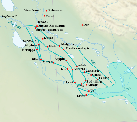
English: Location map of the main cities of Lower Mesopotamia during the Old Babylonian period (2004-1595 BC). With the approximate course of the rivers and the ancient shoreline of the Gulf. Français : Carte de localisation des principales villes de la Basse Mésopotamie durant la période paléo-babylonienne (2004-1595 av. J.-C.). Avec le tracé approximatif des fleuves et l'ancien trait de côte du Golfe. |
| تاريخ | (UTC) |
| مصدر | |
| مؤلف |
|
| هذا رسمٌ مُعَدَّلٌ رقميَّاً من النسخة الأصليَّة. التعديلات هي: Ajout des villes, du tracé des fleuves antiques et du trait de côte du Golfe.. يُمكن الاطلاع على النسخة الأصليَّة هنا: Near East topographic map-blank.svg:
|
أنا، صاحب حقوق التأليف والنشر لهذا العمل، أنشر هذا العمل تحت الرخص التالية:
- إنت حر:
- فى المشاركه – علشان نسخ و توزيع و بث العمل
- إنك تمزج – فى تكييف العمل
- بالشروط دى:
- نسبه ل – لازم يتنسب العمل للى مألفه بشكل مناسب و توفير رابط للرخصه وتحديد اذا حصلت تغييرات. ممكن ده يتعمل بأى طريقه معقوله، لكن مش بطريقه تشير ان مانح الرخصه بيوافقك على الاستعمال.
- مشاركه زي – لو عدت إنتاج المواد أو غيرت فيها، لازم تنشر مساهماتك اللى جايه من الأصل تحت ترخيص الأصل نفسه أو تحت ترخيص متوافق معاه.

|
يسمح بنسخ و توزيع و / أو تعديل الوثيقه دى تحت شروط رخصة جنو للوثائق الحره، الإصدار 1.2 أو أى إصدار تنشره مؤسسة البرمجيات الحره؛ بدون أقسام ثابته و بدون نصوص أغلفه أماميه و بدون نصوص أغلفه خلفيه. نسخه من الرخصه متضمنه ف قسم اسمه GNU Free Documentation License. |
اختار الرخصه اللى تناسبك.
سجلُّ الرَّفع الأصيل
This image is a derivative work of the following images:
- File:Near_East_topographic_map-blank.svg licensed with Cc-by-sa-3.0,2.5,2.0,1.0, GFDL
- 2009-08-18T18:31:37Z Sémhur 2425x1581 (2442670 Bytes) 3 - New try
- 2009-08-17T15:39:22Z Sémhur 2425x1581 (1815374 Bytes) 2 - With the background...
- 2009-08-17T15:37:36Z Sémhur 2425x1581 (2836 Bytes) {{Information |Description={{en|1=Blank physical map of the [[:en:Near East|Near East]]}} {{fr|1=Carte physique vierge du [[:fr:Proche-Orient|Proche-Orient]].}} |Source={{own}} |Author=[[User:Sémhur|Sémhur]] |Date=2008-08-1
Uploaded with derivativeFX
تاريخ الفايل
اضغط على الساعه/التاريخ علشان تشوف الفايل زى ما كان فى الوقت ده.
| الساعه / التاريخ | صورة صغيرة | ابعاد | يوزر | تعليق | |
|---|---|---|---|---|---|
| دلوقتي | 10:21، 26 فبراير 2023 | | 440 × 393 (157 كيلوبايت) | Zunkir | opacité, cours d'eau, villes |
| 21:02، 10 ديسمبر 2017 |  | 1,026 × 736 (588 كيلوبايت) | Bulldoc | aggiunta Umma ed il terreno della Guedemma, causa della guerra con Lagash | |
| 01:17، 13 يناير 2017 |  | 1,026 × 736 (814 كيلوبايت) | Kindattu2004 | Cities of Kisurra and Kutalla added | |
| 16:59، 28 سبتمبر 2010 |  | 1,026 × 736 (826 كيلوبايت) | Zunkir | {{Information |Description={{en|1=Location map of the main cities of Lower Mesopotamia during the paleo-babylonian period (2004-1595 BC). With the approximate course of the rivers and the ancient shoreline of the Gulf.}} {{fr|1=Carte de localisation des p |
استخدام الفايل
ال4 صفحة دى فيها وصله للفايل ده:
استخدام الملف العام
الويكيات التانيه دى بتستخدم الفايل ده:
- الاستخدام ف ar.wikipedia.org
- الاستخدام ف ca.wikipedia.org
- الاستخدام ف ceb.wikipedia.org
- الاستخدام ف en.wikipedia.org
- الاستخدام ف es.wikipedia.org
- الاستخدام ف fr.wikipedia.org
- الاستخدام ف it.wikipedia.org
- الاستخدام ف pl.wikipedia.org
اعرض استخدام عام اكتر للملف ده.