
ملف:Alice Springs ridge.jpeg
مافيش ريزوليوشن اعلى متوفر.
Alice_Springs_ridge.jpeg (768 × 511 بكسل حجم الفايل: 436 كيلوبايت، نوع MIME: image/jpeg)
الخلاصة
| موقع الكاميرا | | هذه وغيرها من الصور في مواقعها على: خريطة الشارع المفتوحة |
|---|
الترخيص
Codrington, Stephen. Planet Geography 3rd Edition (2005) [1]
Personal photo by Stephen Codrington uploaded with permission for the benefit of geography on Wikimedia projects. This and other photos by Stephen Codrington are available to download and order at his personal website.
هذا الملف مُرخص تحت رخصة المشاع المبدع نسبة المصنف إلى مؤلفه 2.5 العامة
نسبه ل: Stephen Codrington
- إنت حر:
- فى المشاركه – علشان نسخ و توزيع و بث العمل
- إنك تمزج – فى تكييف العمل
- بالشروط دى:
- نسبه ل – لازم يتنسب العمل للى مألفه بشكل مناسب و توفير رابط للرخصه وتحديد اذا حصلت تغييرات. ممكن ده يتعمل بأى طريقه معقوله، لكن مش بطريقه تشير ان مانح الرخصه بيوافقك على الاستعمال.
تاريخ الفايل
اضغط على الساعه/التاريخ علشان تشوف الفايل زى ما كان فى الوقت ده.
| الساعه / التاريخ | صورة صغيرة | ابعاد | يوزر | تعليق | |
|---|---|---|---|---|---|
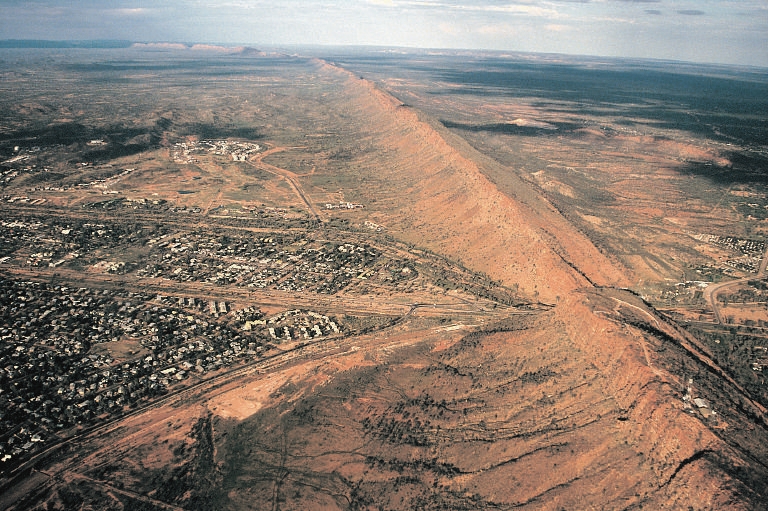
| دلوقتي | 02:57، 12 يوليه 2005 | | 768 × 511 (436 كيلوبايت) | Komencanto~commonswiki | Caption: "''Figure 3.14 One of the larger settlements on the road that crosses Australia from north to south is Alice Springs. This view shows the transport links passing through a convenient gap in the ridge beside which the town has been built. The host |
استخدام الفايل
ال1 صفحة دى فيها وصله للفايل ده:
استخدام الملف العام
الويكيات التانيه دى بتستخدم الفايل ده:
- الاستخدام ف af.wikipedia.org
- الاستخدام ف bg.wikipedia.org
- الاستخدام ف de.wikipedia.org
- الاستخدام ف de.wikivoyage.org
- الاستخدام ف en.wikipedia.org
- الاستخدام ف es.wikipedia.org
- الاستخدام ف fr.wikipedia.org
- الاستخدام ف fr.wikivoyage.org
- الاستخدام ف hu.wikipedia.org
- الاستخدام ف it.wikipedia.org
- الاستخدام ف ja.wikipedia.org
- الاستخدام ف ky.wikipedia.org
- الاستخدام ف ml.wikipedia.org
- الاستخدام ف nl.wikipedia.org
- الاستخدام ف nn.wikipedia.org
- الاستخدام ف ru.wikipedia.org
- الاستخدام ف simple.wikipedia.org
- الاستخدام ف tr.wikipedia.org
- الاستخدام ف uk.wikipedia.org
- الاستخدام ف vi.wikipedia.org
- الاستخدام ف www.wikidata.org