ساوث يوركشير
| South Yorkshire | |
|---|---|
| County | |
| ملف:South Yorkshire montage.png Clockwise from top left: Sheffield city centre from Meersbrook Park, industry in Aldwarke, more rural Hellaby, 12th century Conisbrough Castle in Conisbrough, central Doncaster, and Barnsley | |
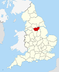
 South Yorkshire shown within England | |
| Coordinates: 53°30′N 1°20′W / 53.500°N 1.333°W | |
| Sovereign state | المملكه المتحده |
| Constituent country | انجلترا |
| Region | Yorkshire and the Humber |
| Established | 1 April 1974 |
| Established by | Local Government Act 1972 |
| Ceremonial county | |
| Lord Lieutenant | Andrew Coombe |
| High Sheriff | Barry Reginald Eldred [1] (2018-19) |
| Area | 1,552 km2 (599 sq mi) |
| – Ranked | 38th of 48 |
| Population (2008 est.) | 1,343,900 |
| – Ranked | 10th of 48 |
| Density | 866/km2 (2,240/sq mi) |
| Ethnicity | 90.7% White 3.4% S.Asian 2.0% Black 1.5% Mixed 2.5% Other |
| Metropolitan county | |
| Government | Sheffield City Region Combined Authority |
| Joint committees | South Yorkshire Joint Secretariat |
| Admin HQ | Barnsley |
| ONS code | 2C |
| GSS code | E11000003 |
| NUTS | UKE3 |
| Website | southyorks |
 Districts of South Yorkshire Metropolitan districts | |
| Districts | |
| Members of Parliament | List of MPs |
| Police | South Yorkshire Police |
| Time zone | GMT (UTC) |
| – Summer (DST) | BST (UTC+1) |
ساوث يوركشير (انجليزى:South Yorkshire), دى وحده من محافظات انجلترا, اتآسست المحافظه دى سنه 1972, عدد سكانها 1,385,000 انسان.[2][3]
مصادر[تعديل]
- ↑ "No. 62229". The London Gazette. 15 مارس 2018. pp. 4814–4814.
- ↑ [1] Archived 2 اكتوبر 2011 at the Wayback Machine
- ↑ Office of the Deputy Prime Minister. "Local Government Finance Statistics England No.16". local.odpm.gov.uk. Archived from the original on 5 يوليه 2007. Retrieved 21 فبراير 2008.
{{cite web}}: Unknown parameter|deadurl=ignored (help)
لينكات برانى[تعديل]
- ويبسايت رسمى
- Images of South Yorkshire Archived 2015-02-10 at the Wayback Machine at the English Heritage Archive
- ساوث يوركشير at مشروع الدليل المفتوح

