الفرق بين النسختين بتاع: «ماديرا»
تم حذف المحتوى تمت إضافة المحتوى
info |
جزر ماديرا |
||
| سطر 1: | سطر 1: | ||
{{Geobox|Region |
{{Geobox|Region |
||
<!-- *** Heading *** --> |
<!-- *** Heading *** --> |
||
| name = |
| name = ماديرا |
||
| native_name = |
| native_name = Madeira |
||
| other_name = |
| other_name = |
||
| category = [[Autonomous area|Autonomous Region]] |
| category = [[Autonomous area|Autonomous Region]] |
||
| سطر 191: | سطر 191: | ||
'''جزر ماديرا''' هيا [[ارخبيل]] ف [[المحيط الاطلنطى]] بتحكمها [[بورتوجال]] |
'''جزر ماديرا''' هيا [[ارخبيل]] ف [[المحيط الاطلنطى]] بتحكمها [[بورتوجال]] و عاصمتها [[فونتشال]] |
||
{{افريقيا}} |
{{افريقيا}} |
||
[[تصنيف:جزر|ماديرا]] |
|||
تعديلات من 15:00، 23 مارس 2014
| ماديرا (Madeira) | |||
| Autonomous Region (Região Autónoma) | |||
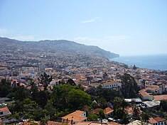
A view of Funchal, the capital city of the autonomous region.
| |||
|
|||
| Official name: Região Autónoma da Madeira | |||
| اصل الاسم: madeira, Portuguese for wood | |||
| شعار: Das ilhas, as mais belas e livres ([Of all islands, the most beautiful and free] Error: {{Lang}}: text has italic markup (help)) | |||
| Nickname: Pérola do Atlântico ([Pearl of the Atlantic] Error: {{Lang}}: text has italic markup (help)) | |||
| Country | |||
|---|---|---|---|
| Autonomous Region | |||
| Region | Atlantic Ocean | ||
| Subregion | Tore-Madeira Ridge | ||
| Position | Madeira Platform, Savage Islands submarine mount | ||
| Islands | Madeira, Porto Santo, Desertas, Selvagens | ||
| Municipalities | Calheta, Câmara de Lobos, Funchal, Machico, Ponta do Sol, Porto Moniz, Porto Santo, Ribeira Brava, Santa Cruz, Santana, São Vicente | ||
| Capital | Funchal | ||
| Largest city | Funchal | ||
| - coordinates | 32°39′4″N 16°54′35″W / 32.65111°N 16.90972°W | ||
| Highest point | Pico Ruivo | ||
| - location | Paul da Serra, Santana, Madeira | ||
| - elevation | 1,862 m (6,109 ft) | ||
| Lowest point | Sea level | ||
| - location | Atlantic Ocean, Madeira | ||
| - elevation | 0 m (0 ft) | ||
| Area | 801 km² (309 sq mi) | ||
| Population | 267,785 (2011) Estimate[1] | ||
| Density | 308.5 / km² (799 / sq mi) | ||
| Settlement | c. 1420 | ||
| - Administrative autonomy | c. 1895 | ||
| - Political autonomy | 4 September 1976 | ||
| Discovery | c. 1415 | ||
| Management | |||
| - location | Assembleia Regional, Sé, Funchal | ||
| - elevation | 16 m (52 ft) | ||
| - coordinates | 32°38′49.96″N 16°54′29.59″W / 32.6472111°N 16.9082194°W | ||
| Government | |||
| - location | Quinta Vigia, Sé, Funchal | ||
| - elevation | 51 m (167 ft) | ||
| - coordinates | 32°38′42.39″N 16°54′57.16″W / 32.6451083°N 16.9158778°W | ||
| President (Government) | Alberto João Jardim (PPD-PSD) | ||
| - President (Assembleia) | José Miguel Jardim d´Olival de Mendonça (PPD-PSD}) | ||
| Timezone | WET ([[UTC{{{utc offset}}}]]) | ||
| - summer (DST) | WEST ([[UTC{{{utc offset DST}}}]]) | ||
| ISO 3166-2 code | PT-30 | ||
| Postal code | 9XXX-XXX | ||
| Area code | (+351) 291 XXX XXX | ||
| ccTLD | .pt | ||
| Date format | dd-mm-yyyy | ||
| Drive | right-side | ||
| Demonym | Madeiran; Madeirense | ||
| Patron Saint | Nossa Senhora do Monte | ||
| Holiday | 1 July | ||
| Anthem | [A Portuguesa] Error: {{Lang}}: text has italic markup (help) (national) [Hino da Madeira] Error: {{Lang}}: text has italic markup (help) (regional) | ||
| Currency | Euro (€)[2] | ||
| Gross domestic product (PPP) | € 6,361 billion[3] | ||
| Per capita GDP | € 25,800-$35,589[3] | ||
|
Location of Madeira relative to Portugal (green) and the rest of the European Union (light green)
| |||
|
Distribution of the islands of the archipelago (not including the Savage islands)
| |||
| Wikimedia Commons: Madeira | |||
| Statistics: Instituto Nacional de Estatística[4] | |||
| Website: www.gov-madeira.pt | |||
| Geographic detail from CAOP (2010)[5] produced by Instituto Geográfico Português (IGP) | |||
جزر ماديرا هيا ارخبيل ف المحيط الاطلنطى بتحكمها بورتوجال و عاصمتها فونتشال
- ↑ http://www.ine.pt/scripts/flex_v10/Main.html
- ↑ Until 2002, the Portuguese escudo was used in financial transactions, and until 1910 the Portuguese real was the currency used by the monarchy of Portugal.
- ↑ أ ب "GDP per inhabitant in 2008" (PDF). Eurostat. Retrieved 29 March 2011.
- ↑ INE, ed. (2010), Censos 2011 - Resultadas Preliminares (in Portuguese), Lisbon, Portugal: Instituto Nacional de Estatística, retrieved 1 July 2011
{{citation}}: Unknown parameter|trans_title=ignored (help)CS1 maint: unrecognized language (link) - ↑ IGP, ed. (2010), Carta Administrativa Oficial de Portugal (in Portuguese), Lisbon, Portugal: Instituto Geográfico Português, retrieved 1 July 2011
{{citation}}: CS1 maint: unrecognized language (link)


